164 Cherokee Dr
Mooresville, NC 28117
- 3Beds
- 3Baths
- 2,543ft²Living Area
- -Lot Size
- 1Pool
- 2Car
- 1997Year Built
- -DOM
- 6Permits
Property Valuations
Latest estimates for 164 Cherokee Dr based on TopHap automated valuation model (AVM).
TopHap Estimate
$459,511
$180/ft²
+$297K above Sold Price
Updated 2 months ago
Last Sold Price
$162,500
$64/ft²
22 years ago
164 Cherokee Dr is valued at $459,511 by TopHap AVM 2 months ago.
164 Cherokee Dr was last sold in 2002 for $162,500.
Permits
164 Cherokee Dr has 6 permit records of total value of $290,400.
Current Ownership
Information about the current owner(s).
Taxes Billed
Taxes billed in 2023$2,702.26From latest Total Assessed Value0.6%Total Assessed Value$447,840=Land+
Assessed Value$75,000Additions
Assessed Value$372,840
In 2023, taxes billed for 164 Cherokee Dr were $2,702.26, which is 0.60% from latest Total Assessed Value of $447,840.
Property History
164 Cherokee Dr has undefined property events records (listings, deeds, permits, tax, foreclosure, loan).
Environment
Environmental factors around 164 Cherokee Dr
Hazard Risks
Hail197Wind161Hurricane124Weather107Nat'l Avg100Particulates91Ozone86Air Pollution85Lead67Earthquake63Carb Mono61Tornado56
12 hazards (Carbon Monoxide, Earthquake Risk, Hail Index, Tornado Index, Hurricane Index, Air Pollution Index, Ozone Index, Wind Index, Weather Risk, Lead Index, Particulate Matter, National Average) are above the national average around 164 Cherokee Dr.
Walkability Index
8 /20
Most Walkable
20-18
Very Walkable
17-15
Somewhat Walkable
14-10
Car Dependent
9-0
164 Cherokee Dr has a walkability score of 8 out of 20, which means that it is in a car dependent area.
Temperature
Seasonal temperature sampled over multiple years
Winter
Average
Low
30°F
High
53°F
Summer
Average
Low
65°F
High
88°F
In the winter at 164 Cherokee Dr, temperatures range from 30.27°F to 52.75°F with an average of 41.51°F. In the summer, the temperature ranges from 65.45°F to 87.71°F with and average of 76.58°F.
School Information
Public/private schools serving 164 Cherokee Dr
Public Schools
Nearby public schools serving 164 Cherokee Dr have ratings undefined, undefined, and undefined.
Neighborhood
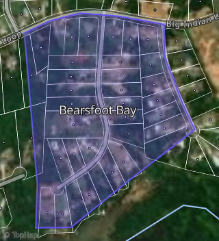
This property is located in Bearsfoot Bay, Mooresville, NC 28117.
Seasonal Housing units 28117
59%of housing is for seasonal rent.
Daytime Population for 28117
+13%of people during work hours.
Boundary map of Bearsfoot Bay.
Crime Index for 28117
86
The crime index in 28117 is 86, which is 0.9 times lower than national average.
Market Trends
Historical market data near 164 Cherokee Dr over selected time period.
Nearby Properties on Cherokee Dr
- 169 Cherokee Dr, Mooresville, NC 28117 (Bearsfoot Bay) is a 3,235 square foot, 3 bedroom, 5 bathroom, 0.75 acre property. It was built in 2002 and has an estimate of $931,541 with a price per ft² of $288.
- 139 Cherokee Dr, Mooresville, NC 28117 (Bearsfoot Bay) is a 2,036 square foot, 3 bedroom, 2 bathroom, 0.78 acre property. It was built in 1998 and has an estimate of $550,178 with a price per ft² of $270.
- 151 Cherokee Dr, Mooresville, NC 28117 (Bearsfoot Bay) is a 2,422 square foot, 3 bedroom, 3.25 bathroom, 0.7 acre property. It was built in 2002 and has an estimate of $809,189 with a price per ft² of $334.
- 129 Cherokee Dr, Mooresville, NC 28117 (Bearsfoot Bay) is a 2,146 square foot, 4 bedroom, 3 bathroom, 0.6 acre property. It was built in 2004 and has an estimate of $642,523 with a price per ft² of $299.
- 159 Cherokee Dr, Mooresville, NC 28117 (Bearsfoot Bay) is a 4,512 square foot, 4 bedroom, 4.25 bathroom, 0.71 acre property. It was built in 1999 and has an estimate of $895,586 with a price per ft² of $198.
- 114 Cherokee Dr, Mooresville, NC 28117 (Bearsfoot Bay) is a 2,499 square foot, 3 bedroom, 3.25 bathroom, 0.8 acre property. It was built in 2013 and has an estimate of $625,819 with a price per ft² of $250.
- 164 Cherokee Dr, Mooresville, NC 28117 (Bearsfoot Bay) is a 2,543 square foot, 3 bedroom, 3.25 bathroom, 0.7 acre property. It was built in 1999 and has an estimate of $577,867 with a price per ft² of $227.
- 104 Cherokee Dr, Mooresville, NC 28117 (Bearsfoot Bay) is a 1,440 square foot, 3 bedroom, 2 bathroom, 0.85 acre property. It was built in 1992 and has an estimate of $412,249 with a price per ft² of $286.
- 160 Cherokee Dr, Mooresville, NC 28117 (Bearsfoot Bay) is a 2,550 square foot, 3 bedroom, 3.25 bathroom, 0.54 acre property. It was built in 2000 and has an estimate of $499,198 with a price per ft² of $196.
- 125 Cherokee Dr, Mooresville, NC 28117 (Bearsfoot Bay) is a 3,040 square foot, 3 bedroom, 3.25 bathroom, 0.67 acre property. It was built in 2002 and has an estimate of $627,785 with a price per ft² of $207.
- 120 Cherokee Dr, Mooresville, NC 28117 (Bearsfoot Bay) is a 1,824 square foot, 3 bedroom, 2 bathroom, 0.82 acre property. It was built in 1997 and has an estimate of $479,355 with a price per ft² of $263.
- 128 Cherokee Dr, Mooresville, NC 28117 (Bearsfoot Bay) is a 2,566 square foot, 3 bedroom, 3.25 bathroom, 0.86 acre property. It was built in 1998 and has an estimate of $499,702 with a price per ft² of $195.
- 165 Cherokee Dr, Mooresville, NC 28117 (Bearsfoot Bay) is a 2,604 square foot, 4 bedroom, 3.25 bathroom, 0.81 acre property. It was built in 1990 and has an estimate of $677,917 with a price per ft² of $260.
- 155 Cherokee Dr, Mooresville, NC 28117 (Bearsfoot Bay) is a 1,881 square foot, 3 bedroom, 3.25 bathroom, 0.63 acre property. It was built in 1999 and has an estimate of $789,834 with a price per ft² of $420.
- 107 Cherokee Dr, Mooresville, NC 28117 (Bearsfoot Bay) is a 1,884 square foot, 3 bedroom, 2 bathroom, 0.82 acre property. It was built in 2003 and has an estimate of $489,700 with a price per ft² of $260.
- 131 Cherokee Dr, Mooresville, NC 28117 (Bearsfoot Bay) is a 3,499 square foot, 4 bedroom, 4.25 bathroom, 0.59 acre property. It was built in 1995 and has an estimate of $605,288 with a price per ft² of $173.
- 121 Cherokee Dr, Mooresville, NC 28117 (Bearsfoot Bay) is a 1,580 square foot, 3 bedroom, 2 bathroom, 0.67 acre property. It was built in 2009 and has an estimate of $508,906 with a price per ft² of $322.
- 115 Cherokee Dr, Mooresville, NC 28117 (Bearsfoot Bay) is a 1,658 square foot, 3 bedroom, 2 bathroom, 0.63 acre property. It was built in 2000 and has an estimate of $482,232 with a price per ft² of $291.
- 171 Cherokee Dr, Mooresville, NC 28117 (Bearsfoot Bay) is a 2,564 square foot, 2 bedroom, 2 bathroom, 0.82 acre property. It was built in 1991 and has an estimate of $839,958 with a price per ft² of $328.
- 134 Cherokee Dr, Mooresville, NC 28117 (Bearsfoot Bay) is a 2,894 square foot, 4 bedroom, 3 bathroom, 1.93 acre property. It was built in 1988 and has an estimate of $686,895 with a price per ft² of $237.
- 168 Cherokee Dr, Mooresville, NC 28117 (Bearsfoot Bay) is a 0.66 acre property.
- 124 Cherokee Dr, Mooresville, NC 28117 (Bearsfoot Bay) is a 2,337 square foot, 3 bedroom, 2 bathroom, 0.81 acre property. It was built in 2015 and has an estimate of $649,185 with a price per ft² of $278.
- 152 Cherokee Dr, Mooresville, NC 28117 (Bearsfoot Bay) is a 3,230 square foot, 4 bedroom, 4.25 bathroom, 0.54 acre property. It was built in 2019 and has an estimate of $884,198 with a price per ft² of $274.
- 147 Cherokee Dr, Mooresville, NC 28117 (Bearsfoot Bay) is a 2,000 square foot, 5 bedroom, 4 bathroom, 0.8 acre property. It was built in 2019 and has an estimate of $894,355 with a price per ft² of $447.
- 155 Cherokee Dr, Mooresville, NC 28117 (Bearsfoot Bay) is a 1 acre property.