12 Randolph St
Napa, CA 94559
- 3Beds
- 2Baths
- 1,173ft²Living Area
- 8,025ft²Lot Size
- -Pool
- 2Car
- 1910Year Built
- -DOM
- 3Permits
Property Valuations
Latest estimates for 12 Randolph St based on TopHap automated valuation model (AVM).
TopHap Estimate
$929,700
$792/ft²
+$628K above Sold Price
Updated 3 months ago
Last Sold Price
$302,000
$257/ft²
14 years ago
12 Randolph St is valued at $929,700 by TopHap AVM 3 months ago.
12 Randolph St was last sold in 2009 for $302,000.
Permits
12 Randolph St has 3 permit records.
Current Ownership
Information about the current owner(s).
Taxes Billed
Taxes billed in 2023$5,157.90From latest Total Assessed Value1.29%Total Assessed Value$399,648=Land+
Assessed Value$186,099Additions
Assessed Value$213,549
In 2023, taxes billed for 12 Randolph St were $5,157.9, which is 1.29% from latest Total Assessed Value of $399,648.
Property History
12 Randolph St has undefined property events records (listings, deeds, permits, tax, foreclosure, loan).
Environment
Environmental factors around 12 Randolph St
Hazard Risks
Earthquake400Nat'l Avg100Carb Mono96Particulates94Ozone88Air Pollution88Lead38Hail0Hurricane0Tornado0Weather0Wind0
7 hazards (Carbon Monoxide, Earthquake Risk, Air Pollution Index, Ozone Index, Lead Index, Particulate Matter, National Average) are above the national average around 12 Randolph St.
Walkability Index
9 /20
Most Walkable
20-18
Very Walkable
17-15
Somewhat Walkable
14-10
Car Dependent
9-0
12 Randolph St has a walkability score of 9 out of 20, which means that it is in a car dependent area.
Noise Level
47 dB
Quiet Suburban Residential 0-49
Suburban Residential 50-54
Urban Residential 55-59
Noisy Urban Residential 60-64
Very Noisy Urban Residential 65+
Noise at 12 Randolph St is around 47dBs, which is comparable to a Quiet Suburban Residential area.
Temperature
Seasonal temperature sampled over multiple years
Winter
Average
Low
39°F
High
57°F
Summer
Average
Low
53°F
High
80°F
In the winter at 12 Randolph St, temperatures range from 39.02°F to 57.44°F with an average of 48.23°F. In the summer, the temperature ranges from 53.25°F to 80.46°F with and average of 66.86°F.
School Information
Public/private schools serving 12 Randolph St
Public Schools
Nearby public schools serving 12 Randolph St have ratings undefined, undefined, and undefined.
Neighborhood
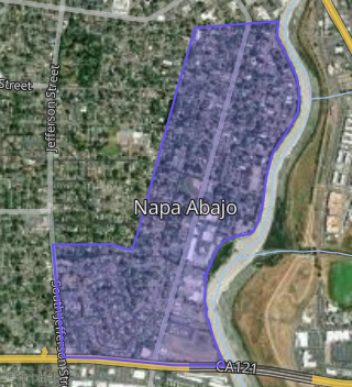
This property is located in Napa Abajo, Napa, CA 94559.
Seasonal Housing units 94559
39%of housing is for seasonal rent.
Daytime Population for 94559
+15%of people during work hours.
Boundary map of Napa Abajo.
Crime Index for 94559
110
The crime index in 94559 is 110, which is 1.1 times higher than national average.
Market Trends
Historical market data near 12 Randolph St over selected time period.
Nearby Properties on Randolph St
- 344 Randolph St, Napa, CA 94559 (Napa Abajo) is a 2,305 square foot, 3 bedroom, 2 bathroom, 0.2 acre property. It was built in 1955 and has an estimate of $1,427,083 with a price per ft² of $619.
- 352 Randolph St, Napa, CA 94559 (Napa Abajo) is a 900 square foot, 2 bedroom, 1 bathroom, 0.1 acre property. It was built in 1920 and has an estimate of $1,050,025 with a price per ft² of $1,167.
- 360 Randolph St, Napa, CA 94559 (Napa Abajo) is a 1,796 square foot, 2 bedroom, 2 bathroom, 0.1 acre property. It was built in 1896 and has an estimate of $1,951,652 with a price per ft² of $1,087.
- 366 Randolph St, Napa, CA 94559 (Napa Abajo) is a 1,350 square foot, 3 bedroom, 2 bathroom, 0.1 acre property. It was built in 1920 and has an estimate of $1,151,459 with a price per ft² of $853.
- 235 Randolph St, Napa, CA 94559 (Napa Abajo) is a 0.23 acre property.
- 929 Randolph St, Napa, CA 94559 (Alta Heights) is a 0.1 acre property.
- View more properties on Randolph St