564 Randolph St
Napa, CA 94559
- -Bed
- -Bath
- 1,668ft²Living Area
- 4,160ft²Lot Size
- -Pool
- 1Car
- 1914Year Built
- -DOM
- 4Permits
Property Valuations
Latest estimates for 564 Randolph St based on TopHap automated valuation model (AVM).
TopHap Estimate
$1,266,000
$758/ft²
+$566K above Sold Price
Updated 3 months ago
Last Sold Price
$700,000
$420/ft²
18 years ago
564 Randolph St is valued at $1,266,000 by TopHap AVM 3 months ago.
564 Randolph St was last sold in 2005 for $700,000.
Permits
564 Randolph St has 4 permit records.
Current Ownership
Information about the current owner(s).
Taxes Billed
Taxes billed in 2023$13,616.76From latest Total Assessed Value1.41%Total Assessed Value$967,087=Land+
Assessed Value$348,078Additions
Assessed Value$619,009
In 2023, taxes billed for 564 Randolph St were $13,616.76, which is 1.41% from latest Total Assessed Value of $967,087.
Property History
564 Randolph St has undefined property events records (listings, deeds, permits, tax, foreclosure, loan).
Environment
Environmental factors around 564 Randolph St
Hazard Risks
Earthquake400Nat'l Avg100Carb Mono96Particulates94Ozone88Air Pollution88Lead38Hail0Hurricane0Tornado0Weather0Wind0
7 hazards (Carbon Monoxide, Earthquake Risk, Air Pollution Index, Ozone Index, Lead Index, Particulate Matter, National Average) are above the national average around 564 Randolph St.
Walkability Index
15 /20
Most Walkable
20-18
Very Walkable
17-15
Somewhat Walkable
14-10
Car Dependent
9-0
564 Randolph St has a walkability score of 15 out of 20, which means that it is in a very walkable area.
Temperature
Seasonal temperature sampled over multiple years
Winter
Average
Low
39°F
High
57°F
Summer
Average
Low
53°F
High
80°F
In the winter at 564 Randolph St, temperatures range from 39.02°F to 57.44°F with an average of 48.23°F. In the summer, the temperature ranges from 53.25°F to 80.46°F with and average of 66.86°F.
School Information
Public/private schools serving 564 Randolph St
Public Schools
Nearby public schools serving 564 Randolph St have ratings undefined, undefined, and undefined.
Neighborhood
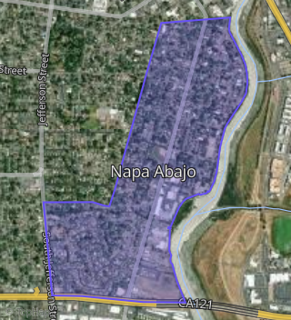
This property is located in Napa Abajo, Napa, CA 94559.
Seasonal Housing units 94559
39%of housing is for seasonal rent.
Daytime Population for 94559
+15%of people during work hours.
Boundary map of Napa Abajo.
Crime Index for 94559
110
The crime index in 94559 is 110, which is 1.1 times higher than national average.
Market Trends
Historical market data near 564 Randolph St over selected time period.
Nearby Properties on Randolph St
- 375 Randolph St, Napa, CA 94559 (Napa Abajo) is a 2,084 square foot, 3 bedroom, 2 bathroom, 0.13 acre property. It was built in 1935 and has an estimate of $1,725,098 with a price per ft² of $828.
- 95 Randolph St, Napa, CA 94559 (Napa Abajo) is a 1,265 square foot, 1 bedroom, 2 bathroom, 0.17 acre property. It was built in 1940 and has an estimate of $1,091,580 with a price per ft² of $863.
- 450 Randolph St, Napa, CA 94559 (Napa Abajo) is a 2,268 square foot and 0.22 acre property.
- 269 Randolph St, Napa, CA 94559 (Napa Abajo) is a 786 square foot, 2 bedroom, 1 bathroom, 0.23 acre property. It was built in 1925 and has an estimate of $884,911 with a price per ft² of $1,126.
- 30 Randolph St, Napa, CA 94559 (Napa Abajo) is a 840 square foot, 1 bathroom, 0.16 acre property. It was built in 1915 and has an estimate of $784,648 with a price per ft² of $934.
- 55 Randolph St, Napa, CA 94559 (Napa Abajo) is a 730 square foot, 2 bedroom, 1 bathroom, 0.18 acre property. It was built in 1925 and has an estimate of $824,504 with a price per ft² of $1,129.
- 69 Randolph St, Napa, CA 94559 (Napa Abajo) is a 1,049 square foot, 2 bedroom, 1 bathroom, 0.16 acre property. It was built in 1939 and has an estimate of $989,628 with a price per ft² of $943.
- 642 Randolph St, Napa, CA 94559 (Downtown Napa) is a 1,140 square foot, 2 bedroom, 1 bathroom, 0.13 acre property. It was built in 1948 and has an estimate of $1,230,188 with a price per ft² of $1,079.
- 384 Randolph St, Napa, CA 94559 (Napa Abajo) is a 1,127 square foot, 2 bedroom, 2 bathroom, 0.09 acre property. It was built in 1925 and has an estimate of $1,247,789 with a price per ft² of $1,107.
- 819 Randolph St, Napa, CA 94559 (Downtown Napa) is a 0.34 acre property.
- 431 Randolph St, Napa, CA 94559 (Napa Abajo) is a 4,247 square foot, 7 bedroom, 6 bathroom, 0.29 acre property. It has an estimate of $1,832,255 with a price per ft² of $431.
- 923 Randolph St, Napa, CA 94559 (Downtown Napa) is a 0.17 acre property.
- 256 Randolph St, Napa, CA 94559 (Napa Abajo) is a 1,770 square foot, 3 bedroom, 2 bathroom, 0.16 acre property. It was built in 1937 and has an estimate of $1,305,650 with a price per ft² of $738.
- 151 Randolph St, Napa, CA 94559 (Napa Abajo) is a 1,531 square foot, 1 bedroom, 2 bathroom, 0.14 acre property. It was built in 1930 and has an estimate of $1,259,402 with a price per ft² of $823.
- 707 Randolph St, Napa, CA 94559 (Downtown Napa) is a 5,790 square foot and 0.17 acre property.
- 103 Randolph St, Napa, CA 94559 (Napa Abajo) is a 858 square foot, 2 bedroom, 1 bathroom, 0.08 acre property. It was built in 1940 and has an estimate of $877,509 with a price per ft² of $1,023.
- 608 Randolph St, Napa, CA 94559 (Downtown Napa) is a 3,892 square foot, 4 bedroom, 3.5 bathroom, 0.19 acre property. It was built in 1888 and has an estimate of $3,544,312 with a price per ft² of $911.
- 58 Randolph St, Napa, CA 94559 (Napa Abajo) is a 2,674 square foot, 4 bedroom, 1 bathroom, 0.47 acre property. It was built in 2013 and has an estimate of $1,518,577 with a price per ft² of $568.
- 376 Randolph St, Napa, CA 94559 (Napa Abajo) is a 2,000 square foot, 4 bedroom, 2 bathroom, 0.18 acre property. It was built in 2000 and has an estimate of $1,284,920 with a price per ft² of $642.
- 505 Randolph St, Napa, CA 94559 (Napa Abajo) is a 912 square foot, 3 bedroom, 1 bathroom, 0.11 acre property. It was built in 1899 and has an estimate of $1,136,431 with a price per ft² of $1,246.
- 118 Randolph St, Napa, CA 94559 (Napa Abajo) is a 915 square foot, 2 bedroom, 1 bathroom, 0.23 acre property. It was built in 1938 and has an estimate of $822,434 with a price per ft² of $899.
- 1205 Randolph St, Napa, CA 94559 (Central Napa) is a 1,800 square foot and 0.11 acre property.
- 309 Randolph St, Napa, CA 94559 (Napa Abajo) is a 2,294 square foot, 4 bedroom, 3.25 bathroom, 0.21 acre property. It was built in 1935 and has an estimate of $1,653,691 with a price per ft² of $721.
- 286 Randolph St, Napa, CA 94559 (Napa Abajo) is a 3,306 square foot, 3 bedroom, 2 bathroom, 0.17 acre property. It was built in 1910 and has an estimate of $2,213,193 with a price per ft² of $669.
- 261 Randolph St, Napa, CA 94559 (Napa Abajo) is a 1,008 square foot, 3 bedroom, 2 bathroom, 0.21 acre property. It was built in 1920 and has an estimate of $1,105,843 with a price per ft² of $1,097.
- View more properties on Randolph St