105 Cain Dr
Santa Maria, CA 93455
- 4Beds
- 3Baths
- 1,746ft²Living Area
- 8,712ft²Lot Size
- -Pool
- -Car
- 1987Year Built
- -DOM
- 1Permit
Property Valuations
Latest estimates for 105 Cain Dr based on TopHap automated valuation model (AVM).
TopHap Estimate
$887,200
$508/ft²
+$232K above Sold Price
Updated 3 months ago
Last Sold Price
$655,000
$375/ft²
2 years ago
105 Cain Dr is valued at $887,200 by TopHap AVM 3 months ago.
105 Cain Dr was last sold in 2021 for $655,000.
Permits
105 Cain Dr has 1 permit records of total value of $5,000.
Current Ownership
Information about the current owner(s).
Taxes Billed
Taxes billed in 2023$8,469.68From latest Total Assessed Value1.27%Total Assessed Value$668,100=Land+
Assessed Value$306,000Additions
Assessed Value$362,100
In 2023, taxes billed for 105 Cain Dr were $8,469.68, which is 1.27% from latest Total Assessed Value of $668,100.
Property History
105 Cain Dr has undefined property events records (listings, deeds, permits, tax, foreclosure, loan).
Environment
Environmental factors around 105 Cain Dr
Hazard Risks
Earthquake272Nat'l Avg100Particulates96Air Pollution92Ozone91Lead89Carb Mono69Tornado3Weather2Hail0Hurricane0Wind0
9 hazards (Carbon Monoxide, Earthquake Risk, Tornado Index, Air Pollution Index, Ozone Index, Weather Risk, Lead Index, Particulate Matter, National Average) are above the national average around 105 Cain Dr.
Walkability Index
10 /20
Most Walkable
20-18
Very Walkable
17-15
Somewhat Walkable
14-10
Car Dependent
9-0
105 Cain Dr has a walkability score of 10 out of 20, which means that it is in a somewhat walkable area.
Noise Level
48 dB
Quiet Suburban Residential 0-49
Suburban Residential 50-54
Urban Residential 55-59
Noisy Urban Residential 60-64
Very Noisy Urban Residential 65+
Noise at 105 Cain Dr is around 48dBs, which is comparable to a Quiet Suburban Residential area.
Temperature
Seasonal temperature sampled over multiple years
Winter
Average
Low
40°F
High
63°F
Summer
Average
Low
52°F
High
74°F
In the winter at 105 Cain Dr, temperatures range from 39.88°F to 62.9°F with an average of 51.39°F. In the summer, the temperature ranges from 52.16°F to 74.2°F with and average of 63.18°F.
School Information
Public/private schools serving 105 Cain Dr
Public Schools
Nearby public schools serving 105 Cain Dr have ratings undefined, undefined, and undefined.
Neighborhood
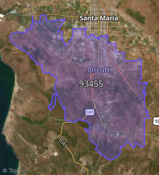
This property is located in Orcutt.
Seasonal Housing units 93455
19%of housing is for seasonal rent.
Daytime Population for 93455
-9%of people during work hours.
Boundary map of Orcutt.
Crime Index for 93455
52
The crime index in 93455 is 52, which is 0.5 times lower than national average.
Market Trends
Historical market data near 105 Cain Dr over selected time period.
Nearby Properties on Cain Dr
- 335 Cain Dr, Santa Maria, CA 93455 is a 1,747 square foot, 4 bedroom, 3.25 bathroom, 0.18 acre property. It was built in 1981 and has an estimate of $610,752 with a price per ft² of $350.
- 435 Cain Dr, Santa Maria, CA 93455 is a 1,747 square foot, 4 bedroom, 3.25 bathroom, 0.26 acre property. It was built in 1983 and has an estimate of $661,912 with a price per ft² of $379.
- 375 Cain Dr, Santa Maria, CA 93455 is a 1,744 square foot, 3 bedroom, 2 bathroom, 0.17 acre property. It was built in 1981 and has an estimate of $591,161 with a price per ft² of $339.
- 195 Cain Dr, Santa Maria, CA 93455 is a 1,744 square foot, 3 bedroom, 3.25 bathroom, 0.18 acre property. It was built in 1981 and has an estimate of $593,990 with a price per ft² of $341.
- 175 Cain Dr, Santa Maria, CA 93455 is a 1,330 square foot, 3 bedroom, 3.25 bathroom, 0.18 acre property. It was built in 1981 and has an estimate of $556,567 with a price per ft² of $418.
- 265 Cain Dr, Santa Maria, CA 93455 is a 1,330 square foot, 3 bedroom, 3.25 bathroom, 0.18 acre property. It was built in 1982 and has an estimate of $558,015 with a price per ft² of $420.
- 332 Cain Dr, Santa Maria, CA 93455 is a 1,744 square foot, 3 bedroom, 2 bathroom, 0.19 acre property. It was built in 1981 and has an estimate of $598,175 with a price per ft² of $343.
- 352 Cain Dr, Santa Maria, CA 93455 is a 1,330 square foot, 3 bedroom, 2.25 bathroom, 0.19 acre property. It was built in 1981 and has an estimate of $574,174 with a price per ft² of $432.
- 322 Cain Dr, Santa Maria, CA 93455 is a 1,330 square foot, 3 bedroom, 3.25 bathroom, 0.18 acre property. It was built in 1982 and has an estimate of $562,039 with a price per ft² of $423.
- 452 Cain Dr, Santa Maria, CA 93455 is a 1,747 square foot, 4 bedroom, 3.25 bathroom, 0.19 acre property. It was built in 1983 and has an estimate of $617,641 with a price per ft² of $354.
- 355 Cain Dr, Santa Maria, CA 93455 is a 1,402 square foot, 3 bedroom, 3.25 bathroom, 0.18 acre property. It was built in 1981 and has an estimate of $558,016 with a price per ft² of $398.
- 325 Cain Dr, Santa Maria, CA 93455 is a 2,400 square foot, 4 bedroom, 3.25 bathroom, 0.18 acre property. It was built in 1981 and has an estimate of $752,075 with a price per ft² of $313.
- 295 Cain Dr, Santa Maria, CA 93455 is a 1,744 square foot, 3 bedroom, 3.25 bathroom, 0.18 acre property. It was built in 1981 and has an estimate of $589,982 with a price per ft² of $338.
- View more properties on Cain Dr