144 T St
Merced, CA 95341
- 3Beds
- 2Baths
- 1,264ft²Living Area
- 7,474ft²Lot Size
- -Pool
- 2Car
- 1994Year Built
- -DOM
- -Permit
Property Valuations
Latest estimates for 144 T St based on TopHap automated valuation model (AVM).
TopHap Estimate
$346,500
$274/ft²
Updated 3 months ago
144 T St is valued at $346,500 by TopHap AVM 3 months ago.
Current Ownership
Information about the current owner(s).
Taxes Billed
Taxes billed in 2023$1,150.72From latest Total Assessed Value1.02%Total Assessed Value$112,748=Land+
Assessed Value$4,593Additions
Assessed Value$108,155
In 2023, taxes billed for 144 T St were $1,150.72, which is 1.02% from latest Total Assessed Value of $112,748.
Property History
144 T St has undefined property events records (listings, deeds, permits, tax, foreclosure, loan).
Environment
Environmental factors around 144 T St
Hazard Risks
Earthquake118Particulates101Nat'l Avg100Air Pollution84Carb Mono80Ozone80Lead40Tornado15Weather6Wind1Hail0Hurricane0
10 hazards (Carbon Monoxide, Earthquake Risk, Tornado Index, Air Pollution Index, Ozone Index, Wind Index, Weather Risk, Lead Index, Particulate Matter, National Average) are above the national average around 144 T St.
Walkability Index
14 /20
Most Walkable
20-18
Very Walkable
17-15
Somewhat Walkable
14-10
Car Dependent
9-0
144 T St has a walkability score of 14 out of 20, which means that it is in a somewhat walkable area.
Temperature
Seasonal temperature sampled over multiple years
Winter
Average
Low
38°F
High
57°F
Summer
Average
Low
59°F
High
93°F
In the winter at 144 T St, temperatures range from 37.75°F to 56.82°F with an average of 47.29°F. In the summer, the temperature ranges from 59.21°F to 93.37°F with and average of 76.29°F.
School Information
Public/private schools serving 144 T St
Public Schools
Nearby public schools serving 144 T St have ratings undefined, undefined, and undefined.
Neighborhood
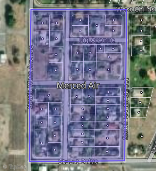
This property is located in Merced Air, Merced, CA 95341.
Seasonal Housing units 95341
17%of housing is for seasonal rent.
Daytime Population for 95341
-26%of people during work hours.
Boundary map of Merced Air.
Crime Index for 95341
122
The crime index in 95341 is 122, which is 1.2 times higher than national average.
Market Trends
Historical market data near 144 T St over selected time period.
Nearby Properties on T St
- 913 T St, Merced, CA 95341 is a 1,012 square foot, 3 bedroom, 1 bathroom, 0.17 acre property. It was built in 1956 and has an estimate of $227,262 with a price per ft² of $225.
- 2039 T St, Merced, CA 95340 is a 1,390 square foot, 2 bedroom, 1 bathroom, 0.17 acre property. It was built in 1951 and has an estimate of $275,604 with a price per ft² of $198.
- 2040 T St, Merced, CA 95340 is a 1,691 square foot, 3 bedroom, 2 bathroom, 0.17 acre property. It was built in 1950 and has an estimate of $346,605 with a price per ft² of $205.
- 731 T St, Merced, CA 95341 is a 1,360 square foot, 3 bedroom, 2 bathroom, 0.17 acre property. It was built in 1951 and has an estimate of $247,011 with a price per ft² of $182.
- 741 T St, Merced, CA 95341 is a 952 square foot, 2 bedroom, 1 bathroom, 0.17 acre property. It was built in 1951 and has an estimate of $219,946 with a price per ft² of $231.
- 935 T St, Merced, CA 95341 is a 1,311 square foot, 3 bedroom, 2 bathroom, 0.17 acre property. It was built in 1957 and has an estimate of $271,566 with a price per ft² of $207.
- 912 T St, Merced, CA 95341 is a 1,012 square foot, 3 bedroom, 1 bathroom, 0.17 acre property. It was built in 1956 and has an estimate of $237,046 with a price per ft² of $234.
- 2326 T St, Merced, CA 95340 (Martinelli Trace) is a 936 square foot, 2 bedroom, 1 bathroom, 0.14 acre property. It was built in 1955 and has an estimate of $255,983 with a price per ft² of $273.
- 61 S T St, Merced, CA 95341 (Merced Air) is a 0.18 acre property.
- 2341 T St, Merced, CA 95340 (Viarengo Trace) is a 1,577 square foot, 3 bedroom, 2 bathroom, 0.13 acre property. It was built in 1953 and has an estimate of $282,150 with a price per ft² of $179.
- 2131 T St, Merced, CA 95340 is a 1,603 square foot, 2 bedroom, 2 bathroom, 0.17 acre property. It was built in 1950 and has an estimate of $260,195 with a price per ft² of $162.
- 1029 T St, Merced, CA 95341 is a 0.17 acre property.
- 136 T St, Merced, CA 95341 is a 2,030 square foot, 6 bedroom, 3 bathroom, 0.17 acre property. It was built in 1959 and has an estimate of $319,041 with a price per ft² of $157.
- 118 T St, Merced, CA 95341 is a 2,205 square foot, 6 bedroom, 3 bathroom, 0.17 acre property. It was built in 1964 and has an estimate of $318,737 with a price per ft² of $145.
- 2140 T St, Merced, CA 95340 is a 1,897 square foot, 3 bedroom, 2 bathroom, 0.17 acre property. It was built in 1950 and has an estimate of $294,796 with a price per ft² of $155.
- 11 S T St, Merced, CA 95341 (Merced Air) is a 750 square foot, 2 bedroom, 1 bathroom, 0.18 acre property. It was built in 1949 and has an estimate of $189,120 with a price per ft² of $252.
- 717 T St, Merced, CA 95341 is a 0.17 acre property.
- 1635 T St, Merced, CA 95340 is a 0.65 acre property.
- 2305 T St, Merced, CA 95340 (Viarengo Trace) is a 0.17 acre property.
- 1901 T St, Merced, CA 95340 (Brizzolara Trace) is a 0.17 acre property.
- 41 S T St, Merced, CA 95341 (Merced Air) is a 1,210 square foot, 3 bedroom, 2 bathroom, 0.18 acre property. It was built in 1949 and has an estimate of $286,073 with a price per ft² of $236.
- 1840 T St, Merced, CA 95340 is a 2,122 square foot, 4 bedroom, 1.5 bathroom, 0.17 acre property. It was built in 1950 and has an estimate of $352,010 with a price per ft² of $166.
- 938 T St, Merced, CA 95341 is a 1,288 square foot, 3 bedroom, 1 bathroom, 0.17 acre property. It was built in 1960 and has an estimate of $202,383 with a price per ft² of $157.
- 200 S T St, Merced, CA 95341 (Merced Air) is a 1,152 square foot, 3 bedroom, 2 bathroom, 0.17 acre property. It was built in 1984 and has an estimate of $246,968 with a price per ft² of $214.
- View more properties on T St