1703 Ashwood Ln
Birmingham, AL 35209
- 2Beds
- 3Baths
- 1,368ft²Living Area
- 178ft²Lot Size
- -Pool
- -Car
- 1988Year Built
- -DOM
- -Permit
Property Valuations
Latest estimates for 1703 Ashwood Ln based on TopHap automated valuation model (AVM).
TopHap Estimate
$435,760
$318/ft²
+$306K above Sold Price
Updated 3 months ago
Last Sold Price
$130,000
$95/ft²
20 years ago
1703 Ashwood Ln is valued at $435,760 by TopHap AVM 3 months ago.
1703 Ashwood Ln was last sold in 2004 for $130,000.
Current Ownership
Information about the current owner(s).
Taxes Billed
Taxes billed in 2022$805.50From latest Total Assessed Value7.38%Total Assessed Value$10,910=Land+
Assessed Value$4,460Additions
Assessed Value$6,450
In 2022, taxes billed for 1703 Ashwood Ln were $805.5, which is 7.38% from latest Total Assessed Value of $10,910.
Property History
1703 Ashwood Ln has undefined property events records (listings, deeds, permits, tax, foreclosure, loan).
Environment
Environmental factors around 1703 Ashwood Ln
Hazard Risks
Tornado470Weather251Hurricane128Carb Mono112Hail112Nat'l Avg100Particulates92Ozone90Air Pollution83Earthquake69Wind55Lead38
12 hazards (Carbon Monoxide, Earthquake Risk, Hail Index, Tornado Index, Hurricane Index, Air Pollution Index, Ozone Index, Wind Index, Weather Risk, Lead Index, Particulate Matter, National Average) are above the national average around 1703 Ashwood Ln.
Walkability Index
12 /20
Most Walkable
20-18
Very Walkable
17-15
Somewhat Walkable
14-10
Car Dependent
9-0
1703 Ashwood Ln has a walkability score of 12 out of 20, which means that it is in a somewhat walkable area.
Temperature
Seasonal temperature sampled over multiple years
Winter
Average
Low
34°F
High
55°F
Summer
Average
Low
68°F
High
89°F
In the winter at 1703 Ashwood Ln, temperatures range from 34.37°F to 55.13°F with an average of 44.75°F. In the summer, the temperature ranges from 67.9°F to 88.94°F with and average of 78.42°F.
School Information
Public/private schools serving 1703 Ashwood Ln
Public Schools
Nearby public schools serving 1703 Ashwood Ln have ratings undefined, undefined, and undefined.
Neighborhood
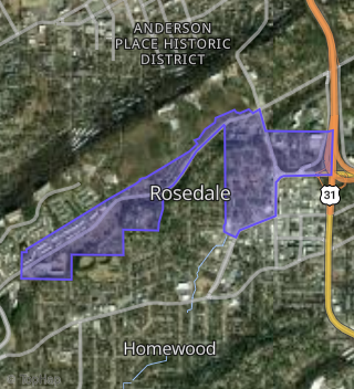
This property is located in Rosedale, Birmingham, AL 35209.
Seasonal Housing units 35209
1%of housing is for seasonal rent.
Daytime Population for 35209
+98%of people during work hours.
Boundary map of Rosedale.
Crime Index for 35209
92
The crime index in 35209 is 92, which is 0.9 times lower than national average.
Market Trends
Historical market data near 1703 Ashwood Ln over selected time period.
Nearby Properties on Ashwood Ln
- 1725 Ashwood Ln, Birmingham, AL 35209 (Five Points South) is a 1,404 square foot, 2 bedroom, 3.25 bathroom, 0.06 acre property. It was built in 2006 and has an estimate of $222,000 with a price per ft² of $158.
- 1651 Ashwood Ln, Birmingham, AL 35209 (Rosedale) is a 1,368 square foot, 2 bedroom, 3.25 bathroom, 0.07 acre property. It was built in 2006 and has an estimate of $247,434 with a price per ft² of $181.
- 1675 Ashwood Ln, Birmingham, AL 35209 (Rosedale) is a 1,350 square foot, 2 bedroom, 3.25 bathroom, 0.05 acre property. It was built in 1990 and has an estimate of $243,018 with a price per ft² of $180.
- 1665 Ashwood Ln, Birmingham, AL 35209 (Rosedale) is a 1,368 square foot, 2 bedroom, 3.25 bathroom, 0.09 acre property. It was built in 1986 and has an estimate of $199,900 with a price per ft² of $146.
- 1695 Ashwood Ln, Birmingham, AL 35209 (Five Points South) is a 0.01 acre property.
- 1647 Ashwood Ln, Birmingham, AL 35209 (Rosedale) is a 1,368 square foot, 2 bedroom, 3.25 bathroom, 0.05 acre property. It was built in 2002 and has an estimate of $246,882 with a price per ft² of $180.
- 1679 Ashwood Ln, Birmingham, AL 35209 (Rosedale) is a 1,428 square foot, 2 bedroom, 3.25 bathroom, 0.05 acre property. It was built in 2002 and has an estimate of $252,402 with a price per ft² of $177.
- 1727 Ashwood Ln, Birmingham, AL 35209 (Five Points South) is a 1,364 square foot, 2 bedroom, 3.25 bathroom, 0.06 acre property. It was built in 2002 and has an estimate of $220,000 with a price per ft² of $161.
- 1731 Ashwood Ln, Birmingham, AL 35209 (Five Points South) is a 1,404 square foot, 2 bedroom, 3.25 bathroom, 0.06 acre property. It was built in 2002 and has an estimate of $222,000 with a price per ft² of $158.
- 1677 Ashwood Ln, Birmingham, AL 35209 (Rosedale) is a 1,368 square foot, 2 bedroom, 3.25 bathroom, 0.05 acre property. It was built in 2006 and has an estimate of $247,158 with a price per ft² of $181.
- 1703 Ashwood Ln, Birmingham, AL 35209 (Five Points South) is a 1,368 square foot, 2 bedroom, 3.25 bathroom, 0.03 acre property. It was built in 1988 and has an estimate of $154,700 with a price per ft² of $113.
- 1721 Ashwood Ln, Birmingham, AL 35209 (Five Points South) is a 1,482 square foot, 2 bedroom, 3.25 bathroom, 0.1 acre property. It was built in 2002 and has an estimate of $199,250 with a price per ft² of $134.
- 1711 Ashwood Ln, Birmingham, AL 35209 (Rosedale) is a 0.01 acre property. It has an estimate of $90,390.
- 1719 Ashwood Ln, Birmingham, AL 35209 (Five Points South) is a 1,404 square foot, 2 bedroom, 3.25 bathroom, 0.12 acre property. It was built in 2002 and has an estimate of $219,000 with a price per ft² of $156.
- 1733 Ashwood Ln, Birmingham, AL 35209 (Five Points South) is a 1,482 square foot, 2 bedroom, 4.5 bathroom, 0.06 acre property. It was built in 2002 and has an estimate of $215,250 with a price per ft² of $145.
- 1685 Ashwood Ln, Birmingham, AL 35209 (Rosedale) is a 1,350 square foot, 2 bedroom, 3.25 bathroom, 0.05 acre property. It was built in 2002 and has an estimate of $245,364 with a price per ft² of $182.
- 1729 Ashwood Ln, Birmingham, AL 35209 (Five Points South) is a 1,364 square foot, 2 bedroom, 3.25 bathroom, 0.06 acre property. It was built in 1996 and has an estimate of $220,000 with a price per ft² of $161.
- 1715 Ashwood Ln, Birmingham, AL 35209 (Five Points South) is a 1,380 square foot, 2 bedroom, 3.25 bathroom, 0.07 acre property. It was built in 2002 and has an estimate of $217,750 with a price per ft² of $158.
- 1717 Ashwood Ln, Birmingham, AL 35209 (Five Points South) is a 1,368 square foot, 2 bedroom, 3.25 bathroom, 0.06 acre property. It was built in 2006 and has an estimate of $217,000 with a price per ft² of $159.
- 1713 Ashwood Ln, Birmingham, AL 35209 (Five Points South) is a 1,380 square foot, 2 bedroom, 3.25 bathroom, 0.05 acre property. It was built in 1989 and has an estimate of $217,750 with a price per ft² of $158.
- 1709 Ashwood Ln, Birmingham, AL 35209 (Rosedale) is a 0.03 acre property.
- 1723 Ashwood Ln, Birmingham, AL 35209 (Five Points South) is a 1,404 square foot, 2 bedroom, 3.25 bathroom, 0.06 acre property. It was built in 2005 and has an estimate of $191,250 with a price per ft² of $136.
- 1705 Ashwood Ln, Birmingham, AL 35209 (Five Points South) is a 1,368 square foot, 2 bedroom, 3.25 bathroom, 0.07 acre property. It was built in 1994 and has an estimate of $146,000 with a price per ft² of $107.
- 1611 Ashwood Ln, Birmingham, AL 35209 (Rosedale) is a 1,404 square foot, 2 bedroom, 3.25 bathroom, 0.05 acre property. It was built in 1985 and has an estimate of $251,022 with a price per ft² of $179.
- 1697 Ashwood Ln, Birmingham, AL 35209 (Rosedale) is a 1,428 square foot, 2 bedroom, 3.25 bathroom, 0.04 acre property. It was built in 2006 and has an estimate of $360,773 with a price per ft² of $253.
- View more properties on Ashwood Ln