194 Krams Ave
Philadelphia, PA 19127
- 3Beds
- 2Baths
- 3,682ft²Living Area
- 2,209ft²Lot Size
- -Pool
- 1Car
- 1900Year Built
- -DOM
- 2Permits
Permits
194 Krams Ave has 2 permit records of total value of $2,650.
Current Ownership
Information about the current owner(s).
Taxes Billed
Taxes billed in 2023$4,479.36From latest Total Assessed Value1.4%Total Assessed Value$320,000=Land+
Assessed Value$64,000Additions
Assessed Value$256,000
In 2023, taxes billed for 194 Krams Ave were $4,479.36, which is 1.40% from latest Total Assessed Value of $320,000.
Property History
194 Krams Ave has undefined property events records (listings, deeds, permits, tax, foreclosure, loan).
Environment
Environmental factors around 194 Krams Ave
Hazard Risks
Wind287Particulates119Hail118Tornado116Weather116Ozone101Nat'l Avg100Air Pollution96Hurricane94Carb Mono93Earthquake83Lead63
12 hazards (Carbon Monoxide, Earthquake Risk, Hail Index, Tornado Index, Hurricane Index, Air Pollution Index, Ozone Index, Wind Index, Weather Risk, Lead Index, Particulate Matter, National Average) are above the national average around 194 Krams Ave.
Walkability Index
16 /20
Most Walkable
20-18
Very Walkable
17-15
Somewhat Walkable
14-10
Car Dependent
9-0
194 Krams Ave has a walkability score of 16 out of 20, which means that it is in a very walkable area.
Temperature
Seasonal temperature sampled over multiple years
Winter
Average
Low
26°F
High
42°F
Summer
Average
Low
65°F
High
85°F
In the winter at 194 Krams Ave, temperatures range from 26.47°F to 41.87°F with an average of 34.17°F. In the summer, the temperature ranges from 64.79°F to 84.53°F with and average of 74.66°F.
School Information
Public/private schools serving 194 Krams Ave
Public Schools
Nearby public schools serving 194 Krams Ave have ratings undefined, and undefined.
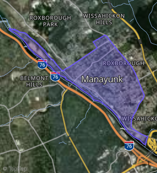
Neighborhood
This property is located in Manayunk, Philadelphia, PA 19127.
Seasonal Housing units 19127
5%of housing is for seasonal rent.
Daytime Population for 19127
-19%of people during work hours.
Boundary map of Manayunk.
Crime Index for 19127
122
The crime index in 19127 is 122, which is 1.2 times higher than national average.
Market Trends
Historical market data near 194 Krams Ave over selected time period.
Nearby Properties on Krams Ave
- 250 Krams Ave, Philadelphia, PA 19128 (Manayunk) is a 1,480 square foot, 3 bedroom, 1 bathroom, 0.03 acre property. It was built in 1900 and has an estimate of $385,000 with a price per ft² of $260.
- 246 Krams Ave, Philadelphia, PA 19128 (Manayunk) is a 0.1 acre property.
- 248 Krams Ave, Philadelphia, PA 19128 (Manayunk) is a 1,480 square foot, 3 bedroom, 1 bathroom, 0.03 acre property. It was built in 1900 and has an estimate of $337,465 with a price per ft² of $228.
- 252 Krams Ave, Philadelphia, PA 19128 (Manayunk) is a 1,480 square foot, 3 bedroom, 1 bathroom, 0.03 acre property. It was built in 1900 and has an estimate of $324,900 with a price per ft² of $220.
- 338 Krams Ave, Philadelphia, PA 19128 (Manayunk) is a 1,155 square foot, 3 bedroom, 1 bathroom, 0.08 acre property. It was built in 1955 and has an estimate of $417,055 with a price per ft² of $361.
- 317 Krams Ave, Philadelphia, PA 19128 (Manayunk) is a 1,440 square foot, 3 bedroom, 1 bathroom, 0.07 acre property. It was built in 1925 and has an estimate of $295,509 with a price per ft² of $205.
- 315 Krams Ave, Philadelphia, PA 19128 (Manayunk) is a 1,440 square foot, 3 bedroom, 1 bathroom, 0.1 acre property. It was built in 1925 and has an estimate of $304,669 with a price per ft² of $212.
- 319 Krams Ave, Philadelphia, PA 19128 (Manayunk) is a 1,440 square foot, 3 bedroom, 1 bathroom, 0.09 acre property. It was built in 1925 and has an estimate of $291,872 with a price per ft² of $203.
- 321 Krams Ave, Philadelphia, PA 19128 (Manayunk) is a 1,440 square foot, 3 bedroom, 1 bathroom, 0.09 acre property. It was built in 1925 and has an estimate of $295,235 with a price per ft² of $205.
- 323 Krams Ave, Philadelphia, PA 19128 (Manayunk) is a 1,440 square foot, 3 bedroom, 1 bathroom, 0.09 acre property. It was built in 1925 and has an estimate of $280,987 with a price per ft² of $195.
- 325 Krams Ave, Philadelphia, PA 19128 (Manayunk) is a 1,440 square foot, 3 bedroom, 2 bathroom, 0.07 acre property. It was built in 1925 and has an estimate of $282,096 with a price per ft² of $196.
- 327 Krams Ave, Philadelphia, PA 19128 (Manayunk) is a 1,440 square foot, 3 bedroom, 1 bathroom, 0.05 acre property. It was built in 1925 and has an estimate of $290,704 with a price per ft² of $202.
- 305 Krams Ave, Philadelphia, PA 19128 (Manayunk) is a 1,344 square foot, 3 bedroom, 1 bathroom, 0.04 acre property. It was built in 1925 and has an estimate of $287,668 with a price per ft² of $214.
- 329 Krams Ave, Philadelphia, PA 19128 (Manayunk) is a 1,440 square foot, 3 bedroom, 1 bathroom, 0.05 acre property. It was built in 1925 and has an estimate of $286,604 with a price per ft² of $199.
- 303 Krams Ave, Philadelphia, PA 19128 (Manayunk) is a 1,344 square foot, 3 bedroom, 1 bathroom, 0.04 acre property. It was built in 1925 and has an estimate of $341,563 with a price per ft² of $254.
- 201 Krams Ave, Philadelphia, PA 19127 (Manayunk) is a 1,611 square foot, 4 bedroom, 1 bathroom, 0.04 acre property. It was built in 1900 and has an estimate of $270,774 with a price per ft² of $168.
- 477 Krams Ave, Philadelphia, PA 19128 (Manayunk) is a 1,104 square foot, 4 bedroom, 1 bathroom, 0.05 acre property. It was built in 1900 and has an estimate of $295,990 with a price per ft² of $268.
- 447 Krams Ave, Philadelphia, PA 19128 (Manayunk) is a 1,120 square foot, 3 bedroom, 1 bathroom, 0.02 acre property. It was built in 1940 and has an estimate of $285,408 with a price per ft² of $255.
- 126 Krams Ave, Philadelphia, PA 19127 (Manayunk) is a 1,275 square foot, 4 bedroom, 1 bathroom, 0.03 acre property. It was built in 1900 and has an estimate of $237,957 with a price per ft² of $187.
- 134 Krams Ave, Philadelphia, PA 19127 (Manayunk) is a 1,272 square foot, 4 bedroom, 1 bathroom, 0.04 acre property. It was built in 1900 and has an estimate of $352,926 with a price per ft² of $277.
- 136 Krams Ave, Philadelphia, PA 19127 (Manayunk) is a 1,198 square foot, 4 bedroom, 1 bathroom, 0.04 acre property. It was built in 1900 and has an estimate of $304,279 with a price per ft² of $254.
- 127 Krams Ave, Philadelphia, PA 19127 (Manayunk) is a 1,350 square foot, 4 bedroom, 1 bathroom, 0.03 acre property. It was built in 1900 and has an estimate of $355,484 with a price per ft² of $263.
- 129 Krams Ave, Philadelphia, PA 19127 (Manayunk) is a 1,242 square foot, 4 bedroom, 1 bathroom, 0.03 acre property. It was built in 1900 and has an estimate of $352,417 with a price per ft² of $284.
- 131 Krams Ave, Philadelphia, PA 19127 (Manayunk) is a 1,212 square foot, 4 bedroom, 1 bathroom, 0.03 acre property. It was built in 1900 and has an estimate of $347,550 with a price per ft² of $287.
- 362 Krams Ave, Philadelphia, PA 19128 (Manayunk) is a 1,120 square foot, 3 bedroom, 1 bathroom, 0.05 acre property. It was built in 1955 and has an estimate of $299,320 with a price per ft² of $267.
- View more properties on Krams Ave