1940 32nd St 44
San Diego, CA 92102
- 6Beds
- 5Baths
- 2,384ft²Living Area
- 5,690ft²Lot Size
- -Pool
- -Car
- 1923Year Built
- -DOM
- 2Permits
Permits
1940 32nd St 44 has 2 permit records.
Current Ownership
Information about the current owner(s).
Taxes Billed
Taxes billed in 2023$10,460.74From latest Total Assessed Value1.23%Total Assessed Value$850,696=Land+
Assessed Value$602,856Additions
Assessed Value$247,840
In 2023, taxes billed for 1940 32nd St 44 were $10,460.74, which is 1.23% from latest Total Assessed Value of $850,696.
Property History
1940 32nd St 44 has undefined property events records (listings, deeds, permits, tax, foreclosure, loan).
Environment
Environmental factors around 1940 32nd St 44
Hazard Risks
Earthquake323Lead124Carb Mono119Particulates109Ozone108Air Pollution105Nat'l Avg100Tornado29Hurricane27Weather20Hail1Wind1
12 hazards (Carbon Monoxide, Earthquake Risk, Hail Index, Tornado Index, Hurricane Index, Air Pollution Index, Ozone Index, Wind Index, Weather Risk, Lead Index, Particulate Matter, National Average) are above the national average around 1940 32nd St 44.
Walkability Index
17 /20
Most Walkable
20-18
Very Walkable
17-15
Somewhat Walkable
14-10
Car Dependent
9-0
1940 32nd St 44 has a walkability score of 17 out of 20, which means that it is in a very walkable area.
Noise Level
50 dB
Quiet Suburban Residential 0-49
Suburban Residential 50-54
Urban Residential 55-59
Noisy Urban Residential 60-64
Very Noisy Urban Residential 65+
Noise at 1940 32nd St 44 is around 50dBs, which is comparable to a Suburban Residential area.
Temperature
Seasonal temperature sampled over multiple years
Winter
Average
Low
45°F
High
66°F
Summer
Average
Low
61°F
High
75°F
In the winter at 1940 32nd St 44, temperatures range from 44.93°F to 65.51°F with an average of 55.22°F. In the summer, the temperature ranges from 61.32°F to 74.78°F with and average of 68.05°F.
School Information
Public/private schools serving 1940 32nd St 44
Public Schools
Nearby public schools serving 1940 32nd St 44 have ratings undefined, undefined, undefined, undefined, and undefined.
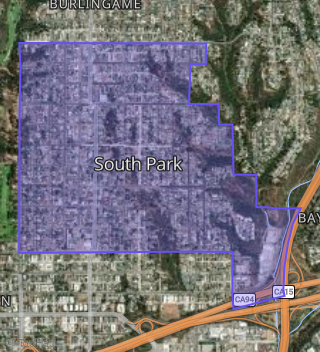
Neighborhood
This property is located in Central San Diego, San Diego, CA 92102.
Seasonal Housing units 92102
18%of housing is for seasonal rent.
Daytime Population for 92102
-15%of people during work hours.
Boundary map of Central San Diego.
Crime Index for 92102
127
The crime index in 92102 is 127, which is 1.3 times higher than national average.
Market Trends
Historical market data near 1940 32nd St 44 over selected time period.
Nearby Properties on 32nd St
- 4431 32nd St #Unit 4, San Diego, CA 92116 (Adams Park) is a 746 square foot, 2 bedroom, 1 bathroom, 0.29 acre property. It was built in 1990 and has an estimate of $456,103 with a price per ft² of $611.
- 4431 32nd St #Unit 8, San Diego, CA 92116 (Adams Park) is a 524 square foot, 1 bedroom, 1 bathroom, 0.29 acre property. It was built in 1990 and has an estimate of $355,374 with a price per ft² of $678.
- 4431 32nd St #Unit 1, San Diego, CA 92116 (Adams Park) is a 746 square foot, 2 bedroom, 1 bathroom, 0.29 acre property. It was built in 1990 and has an estimate of $456,103 with a price per ft² of $611.
- 4431 32nd St #Unit 12, San Diego, CA 92116 (Adams Park) is a 746 square foot, 2 bedroom, 1 bathroom, 0.29 acre property. It was built in 1990 and has an estimate of $461,586 with a price per ft² of $619.
- 4431 32nd St #Unit 7, San Diego, CA 92116 (Adams Park) is a 559 square foot, 1 bedroom, 1 bathroom, 0.29 acre property. It was built in 1990 and has an estimate of $368,191 with a price per ft² of $659.
- 4431 32nd St #Unit 3, San Diego, CA 92116 (Adams Park) is a 723 square foot, 2 bedroom, 1 bathroom, 0.29 acre property. It was built in 1990 and has an estimate of $455,850 with a price per ft² of $630.
- 1924 32nd St, San Diego, CA 92102 (South Park) is a 845 square foot, 2 bedroom, 1 bathroom, 0.09 acre property. It was built in 1922 and has an estimate of $1,156,807 with a price per ft² of $1,369.
- 223 S 32nd St, San Diego, CA 92113 (Logan Heights) is a 975 square foot, 3 bedroom, 2.25 bathroom, 0.05 acre property. It was built in 2006 and has an estimate of $656,414 with a price per ft² of $673.
- 4764 32nd St #Apt 4, San Diego, CA 92116 (Adams North) is a 952 square foot, 2 bedroom, 2 bathroom, 0.17 acre property. It was built in 1983 and has an estimate of $589,191 with a price per ft² of $619.
- 4764 32nd St #Apt 3, San Diego, CA 92116 (Adams North) is a 952 square foot, 2 bedroom, 2 bathroom, 0.17 acre property. It was built in 1983 and has an estimate of $640,985 with a price per ft² of $673.
- 4764 32nd St #Apt 1, San Diego, CA 92116 (Adams North) is a 952 square foot, 2 bedroom, 2 bathroom, 0.17 acre property. It was built in 1983 and has an estimate of $589,098 with a price per ft² of $619.
- 4766 32nd St # 5, San Diego, CA 92116 (Adams North) is a 1,048 square foot, 3 bedroom, 1 bathroom, 0.17 acre property. It was built in 1978 and has an estimate of $633,151 with a price per ft² of $604.
- 1921 32nd St, San Diego, CA 92102 (South Park) is a 1,498 square foot, 2 bedroom, 1 bathroom, 0.09 acre property. It was built in 1912 and has an estimate of $1,443,245 with a price per ft² of $963.
- 425 32nd St, San Diego, CA 92102 (Stockton) is a 576 square foot, 2 bedroom, 1 bathroom, 0.04 acre property. It was built in 2013 and has an estimate of $541,095 with a price per ft² of $939.
- 423 32nd St, San Diego, CA 92102 (Stockton) is a 1,255 square foot, 3 bedroom, 2 bathroom, 0.07 acre property. It was built in 1925 and has an estimate of $825,052 with a price per ft² of $657.
- 4516 32nd St #Apt 5, San Diego, CA 92116 (Adams Park) is a 576 square foot, 1 bedroom, 1 bathroom, 0.14 acre property. It was built in 1980 and has an estimate of $349,688 with a price per ft² of $607.
- 115 S 32nd St, San Diego, CA 92113 (Logan Heights) is a 1,136 square foot, 3 bedroom, 2 bathroom, 0.06 acre property. It was built in 1913 and has an estimate of $713,333 with a price per ft² of $628.
- 620 32nd St, San Diego, CA 92102 (Stockton) is a 1,064 square foot, 4 bedroom, 1 bathroom, 0.07 acre property. It was built in 1920 and has an estimate of $679,895 with a price per ft² of $639.
- 4411 32nd St, San Diego, CA 92116 (Adams Park) is a 896 square foot, 2 bedroom, 1 bathroom, 0.08 acre property. It was built in 1926 and has an estimate of $780,150 with a price per ft² of $871.
- 4061 32nd St, San Diego, CA 92104 (North Park) is a 1,472 square foot, 4 bedroom, 1 bathroom, 0.15 acre property. It was built in 1940 and has an estimate of $964,109 with a price per ft² of $655.
- 4014 32nd St, San Diego, CA 92104 (North Park) is a 2,536 square foot, 4 bedroom, 3 bathroom, 0.11 acre property. It was built in 1952 and has an estimate of $1,333,187 with a price per ft² of $526.
- 4094 32nd St, San Diego, CA 92104 (North Park) is a 696 square foot, 2 bedroom, 1 bathroom, 0.07 acre property. It was built in 1925 and has an estimate of $687,798 with a price per ft² of $988.
- 3747 32nd St #Apt 8, San Diego, CA 92104 (North Park) is a 416 square foot, 1 bedroom, 1 bathroom, 0.14 acre property. It was built in 1987 and has an estimate of $336,834 with a price per ft² of $810.
- 4160 32nd St, San Diego, CA 92104 (North Park) is a 6,264 square foot, 13 bedroom, 10 bathroom, 0.16 acre property. It was built in 1957 and has an estimate of $4,582,528 with a price per ft² of $732.
- 3747 32nd St #Apt 3, San Diego, CA 92104 (North Park) is a 416 square foot, 1 bedroom, 1 bathroom, 0.14 acre property. It was built in 1987 and has an estimate of $336,527 with a price per ft² of $809.
- View more properties on 32nd St