1944 Melvin Rd
Oakland, CA 94602
- 4Beds
- 3Baths
- 2,670ft²Living Area
- 8,800ft²Lot Size
- -Pool
- -Car
- 1977Year Built
- -DOM
- 2Permits
Property Valuations
Latest estimates for 1944 Melvin Rd based on TopHap automated valuation model (AVM).
TopHap Estimate
$1,598,750
$598/ft²
+$974K above Sold Price
Updated 3 months ago
Last Sold Price
$625,000
$234/ft²
21 years ago
1944 Melvin Rd is valued at $1,598,750 by TopHap AVM 3 months ago.
1944 Melvin Rd was last sold in 2002 for $625,000.
Permits
1944 Melvin Rd has 2 permit records of total value of $5,900.
Current Ownership
Information about the current owner(s).
Taxes Billed
Taxes billed in 2023$14,059.78From latest Total Assessed Value1.58%Total Assessed Value$887,405=Land+
Assessed Value$266,221Additions
Assessed Value$621,184
In 2023, taxes billed for 1944 Melvin Rd were $14,059.78, which is 1.58% from latest Total Assessed Value of $887,405.
Property History
1944 Melvin Rd has undefined property events records (listings, deeds, permits, tax, foreclosure, loan).
Environment
Environmental factors around 1944 Melvin Rd
Hazard Risks
Earthquake643Particulates101Nat'l Avg100Carb Mono100Ozone88Air Pollution86Lead43Tornado15Weather6Hail0Hurricane0Wind0
9 hazards (Carbon Monoxide, Earthquake Risk, Tornado Index, Air Pollution Index, Ozone Index, Weather Risk, Lead Index, Particulate Matter, National Average) are above the national average around 1944 Melvin Rd.
Walkability Index
12 /20
Most Walkable
20-18
Very Walkable
17-15
Somewhat Walkable
14-10
Car Dependent
9-0
1944 Melvin Rd has a walkability score of 12 out of 20, which means that it is in a somewhat walkable area.
Temperature
Seasonal temperature sampled over multiple years
Winter
Average
Low
42°F
High
57°F
Summer
Average
Low
54°F
High
72°F
In the winter at 1944 Melvin Rd, temperatures range from 42.42°F to 57.45°F with an average of 49.94°F. In the summer, the temperature ranges from 53.96°F to 72.24°F with and average of 63.1°F.
School Information
Public/private schools serving 1944 Melvin Rd
Public Schools
Nearby public schools serving 1944 Melvin Rd have ratings undefined, undefined, and undefined.
Neighborhood
This property is located in Oakmore, Oakland, CA 94602.
Seasonal Housing units 94602
3%of housing is for seasonal rent.
Daytime Population for 94602
-12%of people during work hours.
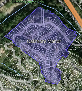
Boundary map of Oakmore.
Crime Index for 94602
113
The crime index in 94602 is 113, which is 1.1 times higher than national average.
Market Trends
Historical market data near 1944 Melvin Rd over selected time period.
Nearby Properties on Melvin Rd
- 1932 Melvin Rd, Oakland, CA 94602 (Oakmore Manor) is a 1,366 square foot, 2 bedroom, 1.5 bathroom, 0.17 acre property. It was built in 1949 and has an estimate of $1,289,502 with a price per ft² of $944.
- 2038 Melvin Rd, Oakland, CA 94602 (Fruitvale Garden Farms) is a 2,237 square foot, 3 bedroom, 3.25 bathroom, 0.2 acre property. It was built in 1992 and has an estimate of $1,355,060 with a price per ft² of $606.
- 2060 Melvin Rd, Oakland, CA 94602 (Fruitvale Garden Farms) is a 2,246 square foot, 3 bedroom, 3.25 bathroom, 0.25 acre property. It was built in 1992 and has an estimate of $1,459,439 with a price per ft² of $650.
- 1955 Melvin Rd, Oakland, CA 94602 (Oakmore Manor) is a 2,384 square foot, 3 bedroom, 4.25 bathroom, 0.64 acre property. It was built in 1955 and has an estimate of $1,996,799 with a price per ft² of $838.
- 1949 Melvin Rd, Oakland, CA 94602 (Oakmore Manor) is a 2,060 square foot, 2 bedroom, 4.25 bathroom, 0.19 acre property. It was built in 1975 and has an estimate of $1,444,842 with a price per ft² of $701.
- 1943 Melvin Rd, Oakland, CA 94602 (Oakmore Manor) is a 2,660 square foot, 4 bedroom, 2 bathroom, 0.18 acre property. It was built in 1949 and has an estimate of $1,879,207 with a price per ft² of $706.
- 1939 Melvin Rd, Oakland, CA 94602 (Oakmore Manor) is a 1,872 square foot, 3 bedroom, 2 bathroom, 0.17 acre property. It was built in 1946 and has an estimate of $1,462,994 with a price per ft² of $782.
- 2010 Melvin Rd, Oakland, CA 94602 (Fruitvale Garden Farms) is a 2,400 square foot, 3 bedroom, 3 bathroom, 0.13 acre property. It was built in 1962 and has an estimate of $1,659,386 with a price per ft² of $691.
- 1924 Melvin Rd, Oakland, CA 94602 (Oakmore Manor) is a 2,131 square foot, 2 bedroom, 2 bathroom, 0.16 acre property. It was built in 1946 and has an estimate of $1,399,628 with a price per ft² of $657.
- 1908 Melvin Rd, Oakland, CA 94602 (Oakmore Manor) is a 1,879 square foot, 3 bedroom, 3 bathroom, 0.12 acre property. It was built in 1936 and has an estimate of $1,526,873 with a price per ft² of $813.
- 1900 Melvin Rd, Oakland, CA 94602 (Oakmore Manor) is a 1,925 square foot, 3 bedroom, 2.25 bathroom, 0.12 acre property. It was built in 1939 and has an estimate of $1,445,311 with a price per ft² of $751.
- 2039 Melvin Rd, Oakland, CA 94602 (Fruitvale Garden Farms) is a 2,039 square foot, 2 bedroom, 3.25 bathroom, 0.15 acre property. It was built in 1980 and has an estimate of $1,303,698 with a price per ft² of $639.
- 2035 Melvin Rd, Oakland, CA 94602 (Fruitvale Garden Farms) is a 2,356 square foot, 4 bedroom, 2.5 bathroom, 0.17 acre property. It was built in 1981 and has an estimate of $1,652,724 with a price per ft² of $701.
- 2275 Melvin Rd, Oakland, CA 94602 (Fruitvale Garden Farms) is a 2,498 square foot, 4 bedroom, 2 bathroom, 0.5 acre property. It was built in 1949 and has an estimate of $1,683,455 with a price per ft² of $674.
- 2265 Melvin Rd, Oakland, CA 94602 (Fruitvale Garden Farms) is a 2,858 square foot, 4 bedroom, 3 bathroom, 0.53 acre property. It was built in 1988 and has an estimate of $1,681,965 with a price per ft² of $589.
- 1800 Melvin Rd, Oakland, CA 94602 (Oakmore Manor) is a 3,195 square foot, 3 bedroom, 3 bathroom, 0.16 acre property. It was built in 1936 and has an estimate of $1,655,147 with a price per ft² of $518.
- 1882 Melvin Rd, Oakland, CA 94602 (Oakmore Manor) is a 2,066 square foot, 2 bedroom, 2 bathroom, 0.12 acre property. It was built in 1941 and has an estimate of $1,514,468 with a price per ft² of $733.
- 1874 Melvin Rd, Oakland, CA 94602 (Oakmore Manor) is a 2,257 square foot, 3 bedroom, 2 bathroom, 0.12 acre property. It was built in 1955 and has an estimate of $1,602,394 with a price per ft² of $710.
- 1866 Melvin Rd, Oakland, CA 94602 (Oakmore Manor) is a 1,790 square foot, 3 bedroom, 2.25 bathroom, 0.12 acre property. It was built in 1947 and has an estimate of $1,459,219 with a price per ft² of $815.
- 1842 Melvin Rd, Oakland, CA 94602 (Oakmore Manor) is a 2,047 square foot, 2 bedroom, 2 bathroom, 0.12 acre property. It was built in 1940 and has an estimate of $1,547,663 with a price per ft² of $756.
- 1832 Melvin Rd, Oakland, CA 94602 (Oakmore Manor) is a 2,950 square foot, 4 bedroom, 4.25 bathroom, 0.12 acre property. It was built in 1936 and has an estimate of $1,835,940 with a price per ft² of $622.
- 1820 Melvin Rd, Oakland, CA 94602 (Oakmore Manor) is a 3,012 square foot, 4 bedroom, 4.25 bathroom, 0.1 acre property. It was built in 1935 and has an estimate of $1,908,213 with a price per ft² of $634.
- 1819 Melvin Rd, Oakland, CA 94602 (Oakmore Manor) is a 3,327 square foot, 5 bedroom, 4.25 bathroom, 0.22 acre property. It was built in 1975 and has an estimate of $1,901,264 with a price per ft² of $678.
- 1837 Melvin Rd, Oakland, CA 94602 (Oakmore Manor) is a 3,223 square foot, 4 bedroom, 4.25 bathroom, 0.15 acre property. It was built in 1937 and has an estimate of $1,910,253 with a price per ft² of $593.
- 1851 Melvin Rd, Oakland, CA 94602 (Oakmore Manor) is a 4,000 square foot, 3 bedroom, 4 bathroom, 0.22 acre property. It was built in 1953 and has an estimate of $2,364,795 with a price per ft² of $935.
- View more properties on Melvin Rd