1996 Sierra Rd
West Sacramento, CA 95691
- 4Beds
- 2Baths
- 2,013ft²Living Area
- 6,098ft²Lot Size
- -Pool
- 2Car
- 2012Year Built
- -DOM
- 5Permits
Property Valuations
Latest estimates for 1996 Sierra Rd based on TopHap automated valuation model (AVM).
TopHap Estimate
$651,750
$323/ft²
+$217K above Sold Price
Updated 3 months ago
Last Sold Price
$435,000
$216/ft²
8 years ago
1996 Sierra Rd is valued at $651,750 by TopHap AVM 3 months ago.
1996 Sierra Rd was last sold in 2016 for $435,000.
Permits
1996 Sierra Rd has 5 permit records of total value of $25,496.
Current Ownership
Information about the current owner(s).
Taxes Billed
Taxes billed in 2023$7,714.08From latest Total Assessed Value1.57%Total Assessed Value$492,106=Land+
Assessed Value$96,714Additions
Assessed Value$395,392
In 2023, taxes billed for 1996 Sierra Rd were $7,714.08, which is 1.57% from latest Total Assessed Value of $492,106.
Property History
1996 Sierra Rd has undefined property events records (listings, deeds, permits, tax, foreclosure, loan).
Environment
Environmental factors around 1996 Sierra Rd
Hazard Risks
Earthquake125Nat'l Avg100Particulates95Air Pollution86Ozone83Carb Mono78Lead41Tornado17Hail7Weather4Wind1Hurricane0
11 hazards (Carbon Monoxide, Earthquake Risk, Hail Index, Tornado Index, Air Pollution Index, Ozone Index, Wind Index, Weather Risk, Lead Index, Particulate Matter, National Average) are above the national average around 1996 Sierra Rd.
Walkability Index
11 /20
Most Walkable
20-18
Very Walkable
17-15
Somewhat Walkable
14-10
Car Dependent
9-0
1996 Sierra Rd has a walkability score of 11 out of 20, which means that it is in a somewhat walkable area.
Temperature
Seasonal temperature sampled over multiple years
Winter
Average
Low
39°F
High
56°F
Summer
Average
Low
57°F
High
92°F
In the winter at 1996 Sierra Rd, temperatures range from 38.87°F to 56.13°F with an average of 47.5°F. In the summer, the temperature ranges from 56.91°F to 92.1°F with and average of 74.51°F.
School Information
Public/private schools serving 1996 Sierra Rd
Public Schools
Nearby public schools serving 1996 Sierra Rd have ratings undefined, and undefined.
Neighborhood
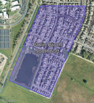
This property is located in Parlin Ranch Southport, West Sacramento, CA 95691.
Seasonal Housing units 95691
8%of housing is for seasonal rent.
Daytime Population for 95691
+20%of people during work hours.
Boundary map of Parlin Ranch Southport.
Crime Index for 95691
91
The crime index in 95691 is 91, which is 0.9 times lower than national average.
Market Trends
Historical market data near 1996 Sierra Rd over selected time period.
Nearby Properties on Sierra Rd
- 1907 Sierra Rd, West Sacramento, CA 95691 (Linden South) is a 2,699 square foot, 4 bedroom, 3 bathroom, 0.11 acre property. It was built in 2013 and has an estimate of $730,115 with a price per ft² of $271.
- 1901 Sierra Rd, West Sacramento, CA 95691 (Linden South) is a 2,277 square foot, 4 bedroom, 3.25 bathroom, 0.09 acre property. It was built in 2015 and has an estimate of $609,518 with a price per ft² of $268.
- 1895 Sierra Rd, West Sacramento, CA 95691 (Linden South) is a 2,699 square foot, 3 bedroom, 3 bathroom, 0.09 acre property. It was built in 2015 and has an estimate of $705,741 with a price per ft² of $261.
- 1889 Sierra Rd, West Sacramento, CA 95691 (Linden South) is a 2,699 square foot, 4 bedroom, 3 bathroom, 0.09 acre property. It was built in 2015 and has an estimate of $689,308 with a price per ft² of $255.
- 1883 Sierra Rd, West Sacramento, CA 95691 (Linden South) is a 2,311 square foot, 4 bedroom, 3.25 bathroom, 0.09 acre property. It was built in 2015 and has an estimate of $634,141 with a price per ft² of $274.
- 1877 Sierra Rd, West Sacramento, CA 95691 (Linden South) is a 2,765 square foot, 4 bedroom, 3 bathroom, 0.09 acre property. It was built in 2015 and has an estimate of $728,439 with a price per ft² of $263.
- 1871 Sierra Rd, West Sacramento, CA 95691 (Linden South) is a 2,765 square foot, 4 bedroom, 3 bathroom, 0.09 acre property. It was built in 2015 and has an estimate of $727,221 with a price per ft² of $263.
- 1865 Sierra Rd, West Sacramento, CA 95691 (Linden South) is a 2,311 square foot, 4 bedroom, 3.25 bathroom, 0.09 acre property. It was built in 2015 and has an estimate of $625,305 with a price per ft² of $271.
- 1859 Sierra Rd, West Sacramento, CA 95691 (Linden South) is a 2,765 square foot, 4 bedroom, 3 bathroom, 0.09 acre property. It was built in 2015 and has an estimate of $715,026 with a price per ft² of $259.
- 1853 Sierra Rd, West Sacramento, CA 95691 (Linden South) is a 2,311 square foot, 3 bedroom, 3.25 bathroom, 0.09 acre property. It was built in 2015 and has an estimate of $621,274 with a price per ft² of $269.
- 1847 Sierra Rd, West Sacramento, CA 95691 (Linden South) is a 1,556 square foot, 3 bedroom, 2 bathroom, 0.09 acre property. It was built in 2015 and has an estimate of $569,246 with a price per ft² of $366.
- 1841 Sierra Rd, West Sacramento, CA 95691 (Linden South) is a 2,699 square foot, 5 bedroom, 3 bathroom, 0.09 acre property. It was built in 2016 and has an estimate of $685,394 with a price per ft² of $254.
- 1835 Sierra Rd, West Sacramento, CA 95691 (Linden South) is a 2,277 square foot, 4 bedroom, 3.25 bathroom, 0.09 acre property. It was built in 2015 and has an estimate of $639,172 with a price per ft² of $281.
- 1829 Sierra Rd, West Sacramento, CA 95691 (Linden South) is a 2,699 square foot, 4 bedroom, 3 bathroom, 0.09 acre property. It was built in 2015 and has an estimate of $701,382 with a price per ft² of $260.
- 1823 Sierra Rd, West Sacramento, CA 95691 (Linden South) is a 1,548 square foot, 3 bedroom, 2 bathroom, 0.11 acre property. It was built in 2015 and has an estimate of $569,881 with a price per ft² of $368.
- 1816 Sierra Rd, West Sacramento, CA 95691 (Linden South) is a 2,699 square foot, 5 bedroom, 3 bathroom, 0.11 acre property. It was built in 2013 and has an estimate of $719,493 with a price per ft² of $267.
- 1822 Sierra Rd, West Sacramento, CA 95691 (Linden South) is a 1,548 square foot, 3 bedroom, 2 bathroom, 0.09 acre property. It was built in 2013 and has an estimate of $559,466 with a price per ft² of $361.
- 1828 Sierra Rd, West Sacramento, CA 95691 (Linden South) is a 1,548 square foot, 3 bedroom, 2 bathroom, 0.09 acre property. It was built in 2013 and has an estimate of $559,466 with a price per ft² of $361.
- 1834 Sierra Rd, West Sacramento, CA 95691 (Linden South) is a 2,699 square foot, 4 bedroom, 3 bathroom, 0.09 acre property. It was built in 2013 and has an estimate of $694,773 with a price per ft² of $257.
- View more properties on Sierra Rd