2016 Smokey Dr
Los Banos, CA 93635
- 3Beds
- 2Baths
- 1,814ft²Living Area
- 6,500ft²Lot Size
- -Pool
- 2Car
- 1989Year Built
- -DOM
- -Permit
Property Valuations
Latest estimates for 2016 Smokey Dr based on TopHap automated valuation model (AVM).
TopHap Estimate
$491,250
$270/ft²
+$281K above Sold Price
Updated 3 months ago
Last Sold Price
$210,000
$116/ft²
22 years ago
2016 Smokey Dr is valued at $491,250 by TopHap AVM 3 months ago.
2016 Smokey Dr was last sold in 2001 for $210,000.
Current Ownership
Information about the current owner(s).
Taxes Billed
Taxes billed in 2023$3,416.88From latest Total Assessed Value1.15%Total Assessed Value$298,165=Land+
Assessed Value$56,787Additions
Assessed Value$241,378
In 2023, taxes billed for 2016 Smokey Dr were $3,416.88, which is 1.15% from latest Total Assessed Value of $298,165.
Property History
2016 Smokey Dr has undefined property events records (listings, deeds, permits, tax, foreclosure, loan).
Environment
Environmental factors around 2016 Smokey Dr
Hazard Risks
Earthquake311Nat'l Avg100Particulates99Ozone85Air Pollution85Carb Mono77Lead44Tornado6Weather2Hail0Hurricane0Wind0
9 hazards (Carbon Monoxide, Earthquake Risk, Tornado Index, Air Pollution Index, Ozone Index, Weather Risk, Lead Index, Particulate Matter, National Average) are above the national average around 2016 Smokey Dr.
Walkability Index
4 /20
Most Walkable
20-18
Very Walkable
17-15
Somewhat Walkable
14-10
Car Dependent
9-0
2016 Smokey Dr has a walkability score of 4 out of 20, which means that it is in a car dependent area.
Temperature
Seasonal temperature sampled over multiple years
Winter
Average
Low
38°F
High
57°F
Summer
Average
Low
59°F
High
92°F
In the winter at 2016 Smokey Dr, temperatures range from 38.24°F to 57.06°F with an average of 47.65°F. In the summer, the temperature ranges from 58.73°F to 92.11°F with and average of 75.42°F.
School Information
Public/private schools serving 2016 Smokey Dr
Public Schools
Nearby public schools serving 2016 Smokey Dr have ratings undefined, undefined, and undefined.
Neighborhood
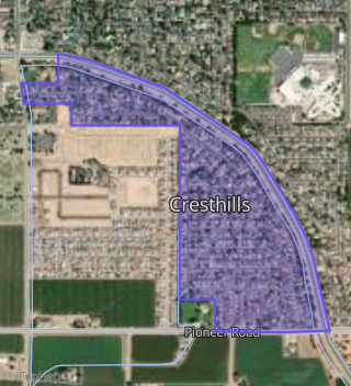
This property is located in Cresthills, Los Banos, CA 93635.
Seasonal Housing units 93635
12%of housing is for seasonal rent.
Daytime Population for 93635
-25%of people during work hours.
Boundary map of Cresthills.
Crime Index for 93635
86
The crime index in 93635 is 86, which is 0.9 times lower than national average.
Market Trends
Historical market data near 2016 Smokey Dr over selected time period.
Nearby Properties on Smokey Dr
- 2015 Smokey Dr, Los Banos, CA 93635 (Cresthills) is a 2,346 square foot, 5 bedroom, 2 bathroom, 0.15 acre property. It was built in 1989 and has an estimate of $521,060 with a price per ft² of $222.
- 2020 Smokey Dr, Los Banos, CA 93635 (Cresthills) is a 2,346 square foot, 5 bedroom, 2 bathroom, 0.14 acre property. It was built in 1990 and has an estimate of $536,190 with a price per ft² of $229.
- 2024 Smokey Dr, Los Banos, CA 93635 (Cresthills) is a 2,029 square foot, 5 bedroom, 2 bathroom, 0.15 acre property. It was built in 1990 and has an estimate of $525,213 with a price per ft² of $259.
- 2028 Smokey Dr, Los Banos, CA 93635 (Cresthills) is a 1,814 square foot, 3 bedroom, 2 bathroom, 0.16 acre property. It was built in 1990 and has an estimate of $469,368 with a price per ft² of $259.
- 2032 Smokey Dr, Los Banos, CA 93635 (Cresthills) is a 1,510 square foot, 3 bedroom, 2 bathroom, 0.15 acre property. It was built in 1990 and has an estimate of $464,710 with a price per ft² of $308.
- 2027 Smokey Dr, Los Banos, CA 93635 (Cresthills) is a 2,346 square foot, 5 bedroom, 3.25 bathroom, 0.15 acre property. It was built in 1990 and has an estimate of $473,196 with a price per ft² of $202.
- 2031 Smokey Dr, Los Banos, CA 93635 (Cresthills) is a 1,859 square foot, 4 bedroom, 2 bathroom, 0.14 acre property. It was built in 1990 and has an estimate of $464,206 with a price per ft² of $250.
- 2036 Smokey Dr, Los Banos, CA 93635 (Cresthills) is a 2,029 square foot, 4 bedroom, 2 bathroom, 0.16 acre property. It was built in 1990 and has an estimate of $510,180 with a price per ft² of $251.
- View more properties on Smokey Dr