20548 Garfield
Redford, MI 48240
- 3Beds
- 1Bath
- 979ft²Living Area
- 0.5acLot Size
- -Pool
- 2Car
- 1951Year Built
- -DOM
- -Permit
Property Valuations
Latest estimates for 20548 Garfield based on TopHap automated valuation model (AVM).
TopHap Estimate
$130,774
$133/ft²
Updated 3 months ago
20548 Garfield is valued at $130,774 by TopHap AVM 3 months ago.
Current Ownership
Information about the current owner(s).
Taxes Billed
Taxes billed in 2019$1,555.11From latest Total Assessed Value2.5%Total Assessed Value$62,200=Land+
Assessed Value$0Additions
Assessed Value$0
In 2019, taxes billed for 20548 Garfield were $1,555.11, which is 2.50% from latest Total Assessed Value of $62,200.
Property History
20548 Garfield has undefined property events records (listings, deeds, permits, tax, foreclosure, loan).
Environment
Environmental factors around 20548 Garfield
Hazard Risks
Hail124Wind124Tornado113Nat'l Avg100Carb Mono95Air Pollution91Ozone90Particulates71Weather68Lead50Earthquake26Hurricane12
12 hazards (Carbon Monoxide, Earthquake Risk, Hail Index, Tornado Index, Hurricane Index, Air Pollution Index, Ozone Index, Wind Index, Weather Risk, Lead Index, Particulate Matter, National Average) are above the national average around 20548 Garfield.
Walkability Index
9 /20
Most Walkable
20-18
Very Walkable
17-15
Somewhat Walkable
14-10
Car Dependent
9-0
20548 Garfield has a walkability score of 9 out of 20, which means that it is in a car dependent area.
Temperature
Seasonal temperature sampled over multiple years
Winter
Average
Low
18°F
High
33°F
Summer
Average
Low
59°F
High
82°F
In the winter at 20548 Garfield, temperatures range from 18.43°F to 33.47°F with an average of 25.95°F. In the summer, the temperature ranges from 58.98°F to 81.57°F with and average of 70.28°F.
School Information
Public/private schools serving 20548 Garfield
Public Schools
Nearby public schools serving 20548 Garfield have ratings undefined, undefined, undefined, and undefined.
Neighborhood
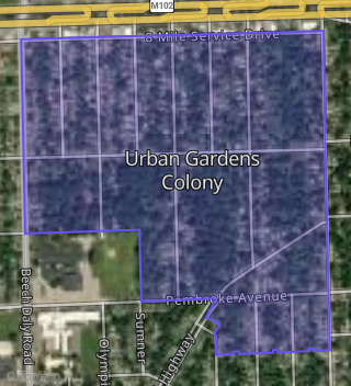
This property is located in Urban Gardens Colony, Redford, MI 48240.
Seasonal Housing units 48240
15%of housing is for seasonal rent.
Daytime Population for 48240
-17%of people during work hours.
Boundary map of Urban Gardens Colony.
Crime Index for 48240
84
The crime index in 48240 is 84, which is 0.8 times lower than national average.
Market Trends
Historical market data near 20548 Garfield over selected time period.
Nearby Properties on Garfield
- 19664 Garfield, Redford, MI 48240 (Urban Gardens Colony) is a 1,025 square foot, 3 bedroom, 2 bathroom, 0.12 acre property. It was built in 1942 and has an estimate of $133,038 with a price per ft² of $130.
- 16598 Garfield, Redford, MI 48240 (Six Mile Heights) is a 932 square foot, 1 bathroom, 0.18 acre property. It was built in 1941 and has an estimate of $133,708 with a price per ft² of $143.
- 19423 Garfield, Redford, MI 48240 (Five Points) is a 1,324 square foot, 1 bathroom, 0.18 acre property. It was built in 1946 and has an estimate of $169,563 with a price per ft² of $128.
- 16844 Garfield, Redford, MI 48240 (Six Mile Heights) is a 1,165 square foot, 1 bathroom, 0.24 acre property. It was built in 1941 and has an estimate of $152,468 with a price per ft² of $131.
- 9630 Garfield, Redford, MI 48239 is a 1,120 square foot, 1 bathroom, 0.13 acre property. It was built in 1968 and has an estimate of $192,835 with a price per ft² of $172.
- 11360 Garfield, Redford, MI 48239 is a 1,339 square foot, 1 bathroom, 0.12 acre property. It was built in 1948 and has an estimate of $214,704 with a price per ft² of $160.
- 9331 Garfield, Redford, MI 48239 is a 1,625 square foot, 2.25 bathroom, 0.32 acre property. It was built in 1966 and has an estimate of $230,462 with a price per ft² of $142.
- 15050 Garfield, Redford, MI 48239 (Supervisors Redford) is a 1,060 square foot, 1 bathroom, 0.1 acre property. It was built in 1983 and has an estimate of $160,886 with a price per ft² of $152.
- 11399 Garfield, Redford, MI 48239 is a 1,112 square foot, 1 bathroom, 0.23 acre property. It was built in 1950 and has an estimate of $200,836 with a price per ft² of $181.
- 17190 Garfield, Redford, MI 48240 (Six Mile Gardens) is a 916 square foot, 1 bathroom, 0.12 acre property. It was built in 1952 and has an estimate of $133,371 with a price per ft² of $146.
- 14114 Garfield, Redford, MI 48239 is a 1,414 square foot, 2.25 bathroom, 0.17 acre property. It was built in 1951 and has an estimate of $236,523 with a price per ft² of $167.
- 17438 Garfield, Redford, MI 48240 (Six Mile Gardens) is a 900 square foot, 1 bathroom, 0.12 acre property. It was built in 1951 and has an estimate of $123,944 with a price per ft² of $138.
- 20505 Garfield, Redford, MI 48240 (Urban Gardens Colony) is a 851 square foot, 1 bathroom, 0.21 acre property. It was built in 1942 and has an estimate of $133,323 with a price per ft² of $157.
- 18634 Garfield, Redford, MI 48240 (Grand Rivera) is a 892 square foot, 1 bathroom, 0.11 acre property. It was built in 1954 and has an estimate of $141,637 with a price per ft² of $159.
- 17382 Garfield, Redford, MI 48240 (Six Mile Gardens) is a 1,116 square foot, 1 bathroom, 0.12 acre property. It was built in 1951 and has an estimate of $127,000 with a price per ft² of $114.
- 11431 Garfield, Redford, MI 48239 is a 1,458 square foot, 3.5 bathroom, 0.14 acre property. It was built in 2005 and has an estimate of $244,236 with a price per ft² of $168.
- 20576 Garfield, Redford, MI 48240 (Urban Gardens Colony) is a 721 square foot, 1 bathroom, 0.48 acre property. It was built in 1940 and has an estimate of $91,883 with a price per ft² of $127.
- 18908 Garfield, Redford, MI 48240 (Grand Rivera) is a 892 square foot, 1 bathroom, 0.12 acre property. It was built in 1954 and has an estimate of $161,620 with a price per ft² of $181.
- 13590 Garfield, Redford, MI 48239 (Sunrest Gardens Homes) is a 1,122 square foot, 1 bathroom, 0.15 acre property. It was built in 1955 and has an estimate of $183,417 with a price per ft² of $163.
- 20435 Garfield, Redford, MI 48240 (Urban Gardens Colony) is a 1,182 square foot, 1 bathroom, 0.22 acre property. It was built in 1942 and has an estimate of $154,886 with a price per ft² of $131.
- 16710 Garfield, Redford, MI 48240 (Six Mile Heights) is a 1,165 square foot, 1 bathroom, 0.12 acre property. It was built in 1941 and has an estimate of $148,449 with a price per ft² of $127.
- 17334 Garfield, Redford, MI 48240 (Six Mile Gardens) is a 1,116 square foot, 1 bathroom, 0.12 acre property. It was built in 1931 and has an estimate of $148,769 with a price per ft² of $133.
- 19483 Garfield, Redford, MI 48240 (Five Points) is a 1,054 square foot, 1 bathroom, 0.18 acre property. It was built in 1953 and has an estimate of $173,875 with a price per ft² of $165.
- 9342 Garfield, Redford, MI 48239 (Marcia Diane) is a 1,082 square foot, 2.25 bathroom, 0.11 acre property. It was built in 1956 and has an estimate of $207,811 with a price per ft² of $192.
- 13444 Garfield, Redford, MI 48239 (Sunrest Gardens Homes) is a 1,072 square foot, 2.25 bathroom, 0.19 acre property. It was built in 1956 and has an estimate of $162,562 with a price per ft² of $152.
- View more properties on Garfield