213 Mansell Dr
Youngstown, OH 44505
- 2Beds
- 1Bath
- 1,124ft²Living Area
- 0.3acLot Size
- -Pool
- 1Car
- 1952Year Built
- -DOM
- -Permit
Property Valuations
Latest estimates for 213 Mansell Dr based on TopHap automated valuation model (AVM).
TopHap Estimate
$83,587
$74/ft²
+$51K above Sold Price
Updated 3 months ago
Last Sold Price
$33,000
$29/ft²
8 years ago
213 Mansell Dr is valued at $83,587 by TopHap AVM 3 months ago.
213 Mansell Dr was last sold in 2015 for $33,000.
Current Ownership
Information about the current owner(s).
Taxes Billed
Taxes billed in 2022$1,377.20From latest Total Assessed Value10.16%Total Assessed Value$13,550=Land+
Assessed Value$3,920Additions
Assessed Value$9,630
In 2022, taxes billed for 213 Mansell Dr were $1,377.2, which is 10.16% from latest Total Assessed Value of $13,550.
Property History
213 Mansell Dr has undefined property events records (listings, deeds, permits, tax, foreclosure, loan).
Environment
Environmental factors around 213 Mansell Dr
Hazard Risks
Hail248Wind240Tornado166Particulates108Ozone104Air Pollution102Nat'l Avg100Weather97Carb Mono87Lead80Earthquake31Hurricane13
12 hazards (Carbon Monoxide, Earthquake Risk, Hail Index, Tornado Index, Hurricane Index, Air Pollution Index, Ozone Index, Wind Index, Weather Risk, Lead Index, Particulate Matter, National Average) are above the national average around 213 Mansell Dr.
Walkability Index
5 /20
Most Walkable
20-18
Very Walkable
17-15
Somewhat Walkable
14-10
Car Dependent
9-0
213 Mansell Dr has a walkability score of 5 out of 20, which means that it is in a car dependent area.
Temperature
Seasonal temperature sampled over multiple years
Winter
Average
Low
20°F
High
37°F
Summer
Average
Low
57°F
High
82°F
In the winter at 213 Mansell Dr, temperatures range from 19.91°F to 36.87°F with an average of 28.39°F. In the summer, the temperature ranges from 57.17°F to 81.99°F with and average of 69.58°F.
School Information
Public/private schools serving 213 Mansell Dr
Public Schools
Nearby public schools serving 213 Mansell Dr have ratings undefined, undefined, and undefined.
Neighborhood
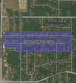
This property is located in Beltrum Heights, Youngstown, OH 44505.
Seasonal Housing units 44505
3%of housing is for seasonal rent.
Daytime Population for 44505
+1%of people during work hours.
Boundary map of Beltrum Heights.
Crime Index for 44505
136
The crime index in 44505 is 136, which is 1.4 times higher than national average.
Market Trends
Historical market data near 213 Mansell Dr over selected time period.
Nearby Properties on Mansell Dr
- 318 Mansell Dr, Youngstown, OH 44505 (Beltrum Heights) is a 1,040 square foot, 3 bedroom, 1 bathroom, 0.21 acre property. It was built in 1952 and has an estimate of $76,752 with a price per ft² of $74.
- 780 Mansell Dr, Youngstown, OH 44505 is a 1,474 square foot, 3 bedroom, 1 bathroom, 0.55 acre property. It was built in 1950 and has an estimate of $116,457 with a price per ft² of $79.
- 824 Mansell Dr, Youngstown, OH 44505 is a 1,360 square foot, 3 bedroom, 2.25 bathroom, 0.69 acre property. It was built in 1951 and has an estimate of $152,945 with a price per ft² of $112.
- 408 Mansell Dr, Youngstown, OH 44505 (Beltrum Heights) is a 1,400 square foot, 3 bedroom, 1 bathroom, 0.43 acre property. It was built in 1955 and has an estimate of $112,176 with a price per ft² of $80.
- 790 Mansell Dr, Youngstown, OH 44505 is a 1,250 square foot, 3 bedroom, 1 bathroom, 0.69 acre property. It was built in 1950 and has an estimate of $123,749 with a price per ft² of $99.
- 427 Mansell Dr, Youngstown, OH 44505 (Beltrum Heights) is a 864 square foot, 2 bedroom, 1 bathroom, 0.38 acre property. It was built in 1954 and has an estimate of $60,840 with a price per ft² of $70.
- 772 Mansell Dr, Youngstown, OH 44505 is a 1,200 square foot, 3 bedroom, 1 bathroom, 0.55 acre property. It was built in 1950 and has an estimate of $105,625 with a price per ft² of $88.
- 338 Mansell Dr, Youngstown, OH 44505 (Beltrum Heights) is a 1,168 square foot, 2 bedroom, 1 bathroom, 0.3 acre property. It was built in 1959 and has an estimate of $103,156 with a price per ft² of $88.
- 830 Mansell Dr, Youngstown, OH 44505 is a 1,461 square foot, 3 bedroom, 2.25 bathroom, 0.69 acre property. It was built in 1946 and has an estimate of $162,250 with a price per ft² of $111.
- 141 Mansell Dr, Youngstown, OH 44505 (Beltrum Heights) is a 1,233 square foot, 3 bedroom, 1 bathroom, 0.23 acre property. It was built in 1964 and has an estimate of $74,360 with a price per ft² of $60.
- 801 Mansell Dr, Youngstown, OH 44505 is a 2,830 square foot, 4 bedroom, 2.25 bathroom, 2 acre property. It was built in 1949 and has an estimate of $190,693 with a price per ft² of $67.
- 136 Mansell Dr, Youngstown, OH 44505 (Beltrum Heights) is a 828 square foot, 2 bedroom, 1 bathroom, 0.24 acre property. It was built in 1947 and has an estimate of $41,164 with a price per ft² of $50.
- 230 Mansell Dr, Youngstown, OH 44505 (Beltrum Heights) is a 1,064 square foot, 3 bedroom, 1 bathroom, 0.21 acre property. It was built in 1953 and has an estimate of $81,836 with a price per ft² of $77.
- 147 Mansell Dr, Youngstown, OH 44505 (Beltrum Heights) is a 1,204 square foot, 5 bedroom, 1 bathroom, 0.23 acre property. It was built in 1964 and has an estimate of $75,374 with a price per ft² of $63.
- 811 Mansell Dr, Youngstown, OH 44505 is a 1,476 square foot, 3 bedroom, 1 bathroom, 2 acre property. It was built in 1976 and has an estimate of $128,479 with a price per ft² of $87.
- 771 Mansell Dr, Youngstown, OH 44505 is a 2,303 square foot, 4 bedroom, 2 bathroom, 2 acre property. It was built in 1954 and has an estimate of $229,926 with a price per ft² of $100.
- 142 Mansell Dr, Youngstown, OH 44505 (Beltrum Heights) is a 1,775 square foot, 4 bedroom, 2 bathroom, 0.23 acre property. It was built in 1948 and has an estimate of $73,308 with a price per ft² of $41.
- 148 Mansell Dr, Youngstown, OH 44505 (Beltrum Heights) is a 1,202 square foot, 3 bedroom, 1 bathroom, 0.24 acre property. It was built in 1952 and has an estimate of $72,652 with a price per ft² of $60.
- 1102 Mansell Dr, Youngstown, OH 44505 is a 2,004 square foot, 2 bedroom, 2 bathroom, 2.09 acre property. It was built in 1950 and has an estimate of $194,530 with a price per ft² of $97.
- 401 Mansell Dr, Youngstown, OH 44505 (Beltrum Heights) is a 1,296 square foot, 3 bedroom, 1 bathroom, 0.26 acre property. It was built in 1953 and has an estimate of $119,990 with a price per ft² of $93.
- 135 Mansell Dr, Youngstown, OH 44505 (Beltrum Heights) is a 960 square foot, 3 bedroom, 1 bathroom, 0.23 acre property. It was built in 1949 and has an estimate of $45,123 with a price per ft² of $47.
- 698 Mansell Dr, Youngstown, OH 44505 is a 2,697 square foot, 4 bedroom, 3.25 bathroom, 1.3 acre property. It was built in 1955 and has an estimate of $221,426 with a price per ft² of $82.
- 233 Mansell Dr, Youngstown, OH 44505 (Beltrum Heights) is a 1,182 square foot, 2 bedroom, 2.25 bathroom, 0.26 acre property. It was built in 1953 and has an estimate of $143,000 with a price per ft² of $121.
- 335 Mansell Dr, Youngstown, OH 44505 (Beltrum Heights) is a 2,825 square foot, 4 bedroom, 3.25 bathroom, 0.51 acre property. It was built in 1974 and has an estimate of $264,500 with a price per ft² of $94.
- 343 Mansell Dr, Youngstown, OH 44505 (Beltrum Heights) is a 891 square foot, 2 bedroom, 1 bathroom, 0.26 acre property. It was built in 1953 and has an estimate of $79,937 with a price per ft² of $90.
- View more properties on Mansell Dr