369 Foster Rd
Santa Maria, CA 93455
- 3Beds
- 2Baths
- 1,472ft²Living Area
- 0.5acLot Size
- -Pool
- -Car
- 1942Year Built
- -DOM
- 6Permits
Property Valuations
Latest estimates for 369 Foster Rd based on TopHap automated valuation model (AVM).
TopHap Estimate
$823,100
$559/ft²
+$323K above Sold Price
Updated 3 months ago
Last Sold Price
$500,000
$340/ft²
19 years ago
369 Foster Rd is valued at $823,100 by TopHap AVM 3 months ago.
369 Foster Rd was last sold in 2005 for $500,000.
Permits
369 Foster Rd has 6 permit records of total value of $315,800.
Current Ownership
Information about the current owner(s).
Taxes Billed
Taxes billed in 2023$13,035.14From latest Total Assessed Value1.32%Total Assessed Value$990,179=Land+
Assessed Value$445,423Additions
Assessed Value$544,756
In 2023, taxes billed for 369 Foster Rd were $13,035.14, which is 1.32% from latest Total Assessed Value of $990,179.
Property History
369 Foster Rd has undefined property events records (listings, deeds, permits, tax, foreclosure, loan).
Environment
Environmental factors around 369 Foster Rd
Hazard Risks
Earthquake272Nat'l Avg100Particulates96Air Pollution92Ozone91Lead89Carb Mono69Tornado3Weather2Hail0Hurricane0Wind0
9 hazards (Carbon Monoxide, Earthquake Risk, Tornado Index, Air Pollution Index, Ozone Index, Weather Risk, Lead Index, Particulate Matter, National Average) are above the national average around 369 Foster Rd.
Walkability Index
11 /20
Most Walkable
20-18
Very Walkable
17-15
Somewhat Walkable
14-10
Car Dependent
9-0
369 Foster Rd has a walkability score of 11 out of 20, which means that it is in a somewhat walkable area.
Noise Level
51 dB
Quiet Suburban Residential 0-49
Suburban Residential 50-54
Urban Residential 55-59
Noisy Urban Residential 60-64
Very Noisy Urban Residential 65+
Noise at 369 Foster Rd is around 51dBs, which is comparable to a Suburban Residential area.
Temperature
Seasonal temperature sampled over multiple years
Winter
Average
Low
40°F
High
63°F
Summer
Average
Low
52°F
High
74°F
In the winter at 369 Foster Rd, temperatures range from 39.88°F to 62.9°F with an average of 51.39°F. In the summer, the temperature ranges from 52.16°F to 74.2°F with and average of 63.18°F.
School Information
Public/private schools serving 369 Foster Rd
Public Schools
Nearby public schools serving 369 Foster Rd have ratings undefined, undefined, and undefined.
Neighborhood
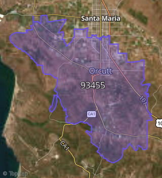
This property is located in Orcutt.
Seasonal Housing units 93455
19%of housing is for seasonal rent.
Daytime Population for 93455
-9%of people during work hours.
Boundary map of Orcutt.
Crime Index for 93455
52
The crime index in 93455 is 52, which is 0.5 times lower than national average.
Market Trends
Historical market data near 369 Foster Rd over selected time period.
Nearby Properties on Foster Rd
- 175 E Foster Rd, Santa Maria, CA 93455 is a 0.51 acre property. It has an estimate of $476,000.
- 135 E Foster Rd, Santa Maria, CA 93455 is a 3,255 square foot and 0.2 acre property.
- 125 E Foster Rd, Santa Maria, CA 93455 is a 6,000 square foot and 0.17 acre property.
- 245 E Foster Rd, Santa Maria, CA 93455 is a 1,158 square foot, 5 bedroom, 3.25 bathroom, 0.74 acre property. It was built in 1947 and has an estimate of $588,173 with a price per ft² of $508.
- 249 E Foster Rd, Santa Maria, CA 93455 is a 1,985 square foot, 3 bedroom, 2 bathroom, 0.43 acre property. It was built in 1900 and has an estimate of $619,696 with a price per ft² of $298.
- 263 E Foster Rd, Santa Maria, CA 93455 is a 1,401 square foot, 3 bedroom, 3.25 bathroom, 0.29 acre property. It was built in 1958 and has an estimate of $620,993 with a price per ft² of $443.
- 625 E Foster Rd, Santa Maria, CA 93455 is a 2,228 square foot, 4 bedroom, 2 bathroom, 1.3 acre property. It was built in 1942 and has an estimate of $867,357 with a price per ft² of $389.
- 577 E Foster Rd, Santa Maria, CA 93455 is a 629 square foot, 1 bedroom, 1 bathroom, 0.51 acre property. It was built in 1940 and has an estimate of $393,868 with a price per ft² of $626.
- 555 E Foster Rd, Santa Maria, CA 93455 is a 3,600 square foot and 1.2 acre property.
- 571 E Foster Rd, Santa Maria, CA 93455 is a 2,137 square foot, 4 bedroom, 3 bathroom, 0.22 acre property. It was built in 1976 and has an estimate of $621,819 with a price per ft² of $291.
- 565 E Foster Rd, Santa Maria, CA 93455 is a 1,937 square foot, 3 bedroom, 2 bathroom, 0.29 acre property. It was built in 1974 and has an estimate of $599,229 with a price per ft² of $309.
- 896 E Foster Rd, Santa Maria, CA 93455 is a 1,710 square foot, 3 bedroom, 2 bathroom, 0.29 acre property. It was built in 1961 and has an estimate of $574,073 with a price per ft² of $336.
- 801 E Foster Rd, Santa Maria, CA 93455 is a 1,498 square foot, 3 bedroom, 2.5 bathroom, 0.17 acre property. It was built in 1976 and has an estimate of $535,325 with a price per ft² of $357.
- 825 E Foster Rd, Santa Maria, CA 93455 is a 1,560 square foot, 3 bedroom, 3.25 bathroom, 0.19 acre property. It was built in 1976 and has an estimate of $563,207 with a price per ft² of $361.
- 1156 E Foster Rd #Apt A, Santa Maria, CA 93455 (Knollwood Terrace) is a 1,800 square foot, 3 bedroom, 3.25 bathroom, 0.02 acre property. It was built in 1982 and has an estimate of $406,996 with a price per ft² of $226.
- 1351 E Foster Rd, Santa Maria, CA 93455 is a 1,345 square foot, 3 bedroom, 2 bathroom, 0.13 acre property. It was built in 1990 and has an estimate of $541,536 with a price per ft² of $373.
- 1369 E Foster Rd, Santa Maria, CA 93455 is a 1,546 square foot, 3 bedroom, 3.25 bathroom, 0.11 acre property. It was built in 1990 and has an estimate of $476,790 with a price per ft² of $308.
- 1330 E Foster Rd, Santa Maria, CA 93455 is a 1,546 square foot, 3 bedroom, 3.25 bathroom, 0.09 acre property. It was built in 1990 and has an estimate of $497,943 with a price per ft² of $322.
- 1338 E Foster Rd, Santa Maria, CA 93455 is a 1,345 square foot, 3 bedroom, 2 bathroom, 0.09 acre property. It was built in 1990 and has an estimate of $510,580 with a price per ft² of $380.
- View more properties on Foster Rd