512 Merritt Ave
Oakland, CA 94610
- 8Beds
- 5Baths
- 3,898ft²Living Area
- 6,000ft²Lot Size
- -Pool
- -Car
- 1948Year Built
- -DOM
- 13Permits
Permits
512 Merritt Ave has 13 permit records of total value of $25,000.
Current Ownership
Information about the current owner(s).
Taxes Billed
Taxes billed in 2023$23,200.84From latest Total Assessed Value1.64%Total Assessed Value$1,415,058=Land+
Assessed Value$424,517Additions
Assessed Value$990,541
In 2023, taxes billed for 512 Merritt Ave were $23,200.84, which is 1.64% from latest Total Assessed Value of $1,415,058.
Property History
512 Merritt Ave has undefined property events records (listings, deeds, permits, tax, foreclosure, loan).
Environment
Environmental factors around 512 Merritt Ave
Hazard Risks
Earthquake507Nat'l Avg100Carb Mono97Particulates97Air Pollution86Ozone85Lead43Tornado19Weather9Hail0Hurricane0Wind0
9 hazards (Carbon Monoxide, Earthquake Risk, Tornado Index, Air Pollution Index, Ozone Index, Weather Risk, Lead Index, Particulate Matter, National Average) are above the national average around 512 Merritt Ave.
Walkability Index
15 /20
Most Walkable
20-18
Very Walkable
17-15
Somewhat Walkable
14-10
Car Dependent
9-0
512 Merritt Ave has a walkability score of 15 out of 20, which means that it is in a very walkable area.
Noise Level
43 dB
Quiet Suburban Residential 0-49
Suburban Residential 50-54
Urban Residential 55-59
Noisy Urban Residential 60-64
Very Noisy Urban Residential 65+
Noise at 512 Merritt Ave is around 43dBs, which is comparable to a Quiet Suburban Residential area.
Temperature
Seasonal temperature sampled over multiple years
Winter
Average
Low
43°F
High
58°F
Summer
Average
Low
55°F
High
71°F
In the winter at 512 Merritt Ave, temperatures range from 43.09°F to 57.96°F with an average of 50.53°F. In the summer, the temperature ranges from 54.7°F to 71.44°F with and average of 63.07°F.
School Information
Public/private schools serving 512 Merritt Ave
Public Schools
Nearby public schools serving 512 Merritt Ave have ratings undefined, undefined, and undefined.
Neighborhood
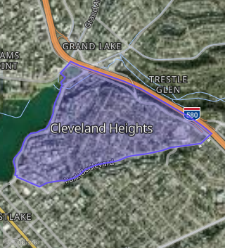
This property is located in Cleveland Heights, Oakland, CA 94610.
Seasonal Housing units 94610
10%of housing is for seasonal rent.
Daytime Population for 94610
-17%of people during work hours.
Boundary map of Cleveland Heights.
Crime Index for 94610
127
The crime index in 94610 is 127, which is 1.3 times higher than national average.
Market Trends
Historical market data near 512 Merritt Ave over selected time period.
Nearby Properties on Merritt Ave
- 535 Merritt Ave #Apt 1, Oakland, CA 94610 (Lake Knoll) is a 6,160 square foot, 8 bedroom, 9 bathroom, 0.11 acre property. It was built in 1955 and has an estimate of $3,090,343 with a price per ft² of $502.
- 590 Merritt Ave, Oakland, CA 94610 (Cleveland Heights) is a 12,737 square foot, 12 bedroom, 12 bathroom, 0.12 acre property. It was built in 1928 and has an estimate of $6,180,630 with a price per ft² of $485.
- 435 Merritt Ave, Oakland, CA 94610 (Cleveland Heights) is a 0.1 acre property.
- 567 Merritt Ave, Oakland, CA 94610 (Lake Knoll) is a 0.11 acre property.
- 595 Merritt Ave, Oakland, CA 94610 (Lake Knoll) is a 14,265 square foot, 14 bedroom, 18 bathroom, 0.15 acre property. It was built in 1926 and has an estimate of $7,461,873 with a price per ft² of $523.
- 520 Merritt Ave, Oakland, CA 94610 (Cleveland Heights) is a 3,672 square foot, 5 bedroom, 5 bathroom, 0.14 acre property. It was built in 1951 and has an estimate of $1,383,334 with a price per ft² of $377.
- 579 Merritt Ave, Oakland, CA 94610 (Lake Knoll) is a 3,120 square foot, 4 bedroom, 3 bathroom, 0.12 acre property. It was built in 1954 and has an estimate of $1,819,712 with a price per ft² of $583.
- 395 Merritt Ave #Apt 101, Oakland, CA 94610 (Cleveland Heights) is a 875 square foot, 2 bedroom, 2 bathroom, 0.13 acre property. It was built in 1990 and has an estimate of $790,200 with a price per ft² of $903.
- 395 Merritt Ave #Apt 303, Oakland, CA 94610 (Cleveland Heights) is a 900 square foot, 2 bedroom, 2 bathroom, 0.13 acre property. It was built in 1990 and has an estimate of $810,431 with a price per ft² of $900.
- 395 Merritt Ave #Apt 301, Oakland, CA 94610 (Cleveland Heights) is a 875 square foot, 2 bedroom, 2 bathroom, 0.13 acre property. It was built in 1990 and has an estimate of $790,200 with a price per ft² of $903.
- 395 Merritt Ave #Apt 203, Oakland, CA 94610 (Cleveland Heights) is a 900 square foot, 2 bedroom, 2 bathroom, 0.13 acre property. It was built in 1990 and has an estimate of $810,431 with a price per ft² of $900.
- 527 Merritt Ave, Oakland, CA 94610 (Lake Knoll) is a 3,578 square foot, 6 bedroom, 4.25 bathroom, 0.11 acre property. It was built in 1923 and has an estimate of $2,080,614 with a price per ft² of $582.
- 551 Merritt Ave # 2, Oakland, CA 94610 (Lake Knoll) is a 1,268 square foot, 2 bedroom, 2 bathroom, 0.12 acre property. It was built in 1997 and has an estimate of $895,145 with a price per ft² of $706.
- 501 Merritt Ave, Oakland, CA 94610 (Cleveland Heights) is a 1,201 square foot, 2 bedroom, 2 bathroom, 0.17 acre property. It was built in 1962 and has an estimate of $954,650 with a price per ft² of $795.
- 501 Merritt Ave, Oakland, CA 94610 (Cleveland Heights) is a 1,201 square foot, 2 bedroom, 2 bathroom, 0.17 acre property.
- 507 Merritt Ave, Oakland, CA 94610 (Cleveland Heights) is a 1,202 square foot, 2 bedroom, 2 bathroom, 0.17 acre property. It was built in 1962 and has an estimate of $952,322 with a price per ft² of $792.
- 503 Merritt Ave, Oakland, CA 94610 (Cleveland Heights) is a 1,201 square foot, 2 bedroom, 2 bathroom, 0.17 acre property. It was built in 1962 and has an estimate of $951,433 with a price per ft² of $792.
- 395 Merritt Ave #Apt 102, Oakland, CA 94610 (Cleveland Heights) is a 900 square foot, 2 bedroom, 2 bathroom, 0.13 acre property. It was built in 1990 and has an estimate of $797,888 with a price per ft² of $887.
- 395 Merritt Ave #Apt 103, Oakland, CA 94610 (Cleveland Heights) is a 900 square foot, 2 bedroom, 2 bathroom, 0.13 acre property. It was built in 1990 and has an estimate of $797,888 with a price per ft² of $887.
- 395 Merritt Ave #Apt 104, Oakland, CA 94610 (Cleveland Heights) is a 1,005 square foot, 2 bedroom, 2 bathroom, 0.13 acre property. It was built in 1990 and has an estimate of $899,087 with a price per ft² of $895.
- 395 Merritt Ave #Apt 204, Oakland, CA 94610 (Cleveland Heights) is a 1,005 square foot, 2 bedroom, 2 bathroom, 0.13 acre property. It was built in 1990 and has an estimate of $899,087 with a price per ft² of $895.
- 395 Merritt Ave #Apt 202, Oakland, CA 94610 (Cleveland Heights) is a 900 square foot, 2 bedroom, 2 bathroom, 0.13 acre property. It was built in 1990 and has an estimate of $797,888 with a price per ft² of $887.
- 395 Merritt Ave #Apt 201, Oakland, CA 94610 (Cleveland Heights) is a 875 square foot, 2 bedroom, 2 bathroom, 0.13 acre property. It was built in 1990 and has an estimate of $777,971 with a price per ft² of $889.
- 395 Merritt Ave #Apt 302, Oakland, CA 94610 (Cleveland Heights) is a 900 square foot, 2 bedroom, 2 bathroom, 0.13 acre property. It was built in 1990 and has an estimate of $797,888 with a price per ft² of $887.
- 395 Merritt Ave #Apt 304, Oakland, CA 94610 (Cleveland Heights) is a 1,005 square foot, 2 bedroom, 2 bathroom, 0.13 acre property. It was built in 1990 and has an estimate of $899,087 with a price per ft² of $895.
- View more properties on Merritt Ave