6737 Mitchell St 39
Philadelphia, PA 19128
- 4Beds
- -Bath
- 1,680ft²Living Area
- 9,260ft²Lot Size
- -Pool
- 5Car
- 1930Year Built
- -DOM
- -Permit
Property Valuations
Latest estimates for 6737 Mitchell St 39 based on TopHap automated valuation model (AVM).
TopHap Estimate
$373,361
$222/ft²
Updated 3 months ago
6737 Mitchell St 39 is valued at $373,361 by TopHap AVM 3 months ago.
Current Ownership
Information about the current owner(s).
Taxes Billed
Taxes billed in 2023$3,012.37From latest Total Assessed Value1.02%Total Assessed Value$295,200=Land+
Assessed Value$0Additions
Assessed Value$0
In 2023, taxes billed for 6737 Mitchell St 39 were $3,012.37, which is 1.02% from latest Total Assessed Value of $295,200.
Property History
6737 Mitchell St 39 has undefined property events records (listings, deeds, permits, tax, foreclosure, loan).
Environment
Environmental factors around 6737 Mitchell St 39
Hazard Risks
Wind292Hail128Particulates117Weather113Tornado112Nat'l Avg100Ozone96Air Pollution95Hurricane90Carb Mono88Earthquake82Lead62
12 hazards (Carbon Monoxide, Earthquake Risk, Hail Index, Tornado Index, Hurricane Index, Air Pollution Index, Ozone Index, Wind Index, Weather Risk, Lead Index, Particulate Matter, National Average) are above the national average around 6737 Mitchell St 39.
Walkability Index
16 /20
Most Walkable
20-18
Very Walkable
17-15
Somewhat Walkable
14-10
Car Dependent
9-0
6737 Mitchell St 39 has a walkability score of 16 out of 20, which means that it is in a very walkable area.
Temperature
Seasonal temperature sampled over multiple years
Winter
Average
Low
26°F
High
41°F
Summer
Average
Low
64°F
High
84°F
In the winter at 6737 Mitchell St 39, temperatures range from 25.8°F to 41.38°F with an average of 33.59°F. In the summer, the temperature ranges from 64.17°F to 84.1°F with and average of 74.14°F.
School Information
Public/private schools serving 6737 Mitchell St 39
Public Schools
Nearby public schools serving 6737 Mitchell St 39 have ratings undefined, and undefined.
Neighborhood
This property is located in Roxborough Manayunk, Philadelphia, PA 19128.
Seasonal Housing units 19128
5%of housing is for seasonal rent.
Daytime Population for 19128
-19%of people during work hours.
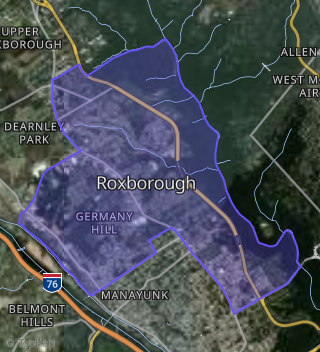
Boundary map of Roxborough / Manayunk.
Crime Index for 19128
81
The crime index in 19128 is 81, which is 0.8 times lower than national average.
Market Trends
Historical market data near 6737 Mitchell St 39 over selected time period.
Nearby Properties on Mitchell St
- 4111 Mitchell St, Philadelphia, PA 19128 (Manayunk) is a 1,200 square foot, 3 bedroom, 1 bathroom, 0.06 acre property. It was built in 1930 and has an estimate of $325,515 with a price per ft² of $271.
- 4113 Mitchell St, Philadelphia, PA 19128 (Manayunk) is a 1,226 square foot, 3 bedroom, 1 bathroom, 0.06 acre property. It was built in 1930 and has an estimate of $345,179 with a price per ft² of $282.
- 4301 Mitchell St, Philadelphia, PA 19128 (Manayunk) is a 1,404 square foot, 3 bedroom, 1 bathroom, 0.04 acre property. It was built in 1900 and has an estimate of $286,292 with a price per ft² of $204.
- 4303 Mitchell St, Philadelphia, PA 19128 (Manayunk) is a 1,404 square foot, 3 bedroom, 1 bathroom, 0.04 acre property. It was built in 1900 and has an estimate of $346,404 with a price per ft² of $247.
- 4305 Mitchell St, Philadelphia, PA 19128 (Manayunk) is a 1,440 square foot, 3 bedroom, 1 bathroom, 0.04 acre property. It was built in 1900 and has an estimate of $351,465 with a price per ft² of $244.
- 4309 Mitchell St, Philadelphia, PA 19128 (Manayunk) is a 1,600 square foot, 4 bedroom, 2 bathroom, 0.04 acre property. It was built in 1900 and has an estimate of $399,456 with a price per ft² of $250.
- 4315 Mitchell St, Philadelphia, PA 19128 (Manayunk) is a 1,600 square foot, 3 bedroom, 2 bathroom, 0.05 acre property.
- 4335 Mitchell St, Philadelphia, PA 19128 (Manayunk) is a 1,713 square foot, 4 bedroom, 1 bathroom, 0.04 acre property. It was built in 1900 and has an estimate of $368,511 with a price per ft² of $215.
- 4339 Mitchell St, Philadelphia, PA 19128 (Manayunk) is a 1,761 square foot, 4 bedroom, 1 bathroom, 0.04 acre property. It was built in 1900 and has an estimate of $396,468 with a price per ft² of $225.
- 4341 Mitchell St, Philadelphia, PA 19128 (Manayunk) is a 1,761 square foot, 4 bedroom, 1 bathroom, 0.04 acre property. It was built in 1900 and has an estimate of $396,028 with a price per ft² of $225.
- 4343 Mitchell St, Philadelphia, PA 19128 (Manayunk) is a 1,761 square foot, 4 bedroom, 1 bathroom, 0.04 acre property. It was built in 1900 and has an estimate of $424,671 with a price per ft² of $241.
- 4345 Mitchell St, Philadelphia, PA 19128 (Manayunk) is a 1,658 square foot, 4 bedroom, 1 bathroom, 0.04 acre property. It was built in 1900 and has an estimate of $396,468 with a price per ft² of $239.
- 4450 Mitchell St, Philadelphia, PA 19128 (Manayunk) is a 1,200 square foot, 3 bedroom, 1 bathroom, 0.05 acre property. It was built in 1930 and has an estimate of $276,912 with a price per ft² of $231.
- 4454 Mitchell St, Philadelphia, PA 19128 (Manayunk) is a 2,166 square foot, 3 bedroom, 2 bathroom, 0.05 acre property.
- 4458 Mitchell St, Philadelphia, PA 19128 (Manayunk) is a 1,360 square foot, 3 bedroom, 1 bathroom, 0.04 acre property. It was built in 1935 and has an estimate of $288,567 with a price per ft² of $212.
- 4460 Mitchell St, Philadelphia, PA 19128 (Manayunk) is a 1,472 square foot, 3 bedroom, 1 bathroom, 0.13 acre property. It was built in 1930 and has an estimate of $329,750 with a price per ft² of $224.
- 4420 Mitchell St, Philadelphia, PA 19128 (Manayunk) is a 1,071 square foot, 2 bedroom, 1 bathroom, 0.02 acre property. It was built in 1930 and has an estimate of $268,500 with a price per ft² of $251.
- 4434 Mitchell St, Philadelphia, PA 19128 (Manayunk) is a 1,700 square foot, 5 bedroom, 3 bathroom, 0.05 acre property.
- 4438 Mitchell St, Philadelphia, PA 19128 (Manayunk) is a 1,700 square foot, 5 bedroom, 1 bathroom, 0.05 acre property. It was built in 1930 and has an estimate of $372,000 with a price per ft² of $219.
- 4431 Mitchell St, Philadelphia, PA 19128 (Manayunk) is a 1,408 square foot, 3 bedroom, 1 bathroom, 0.03 acre property. It was built in 1935 and has an estimate of $286,915 with a price per ft² of $204.
- 4437 Mitchell St, Philadelphia, PA 19128 (Manayunk) is a 1,272 square foot, 3 bedroom, 1.1 bathroom, 0.03 acre property. It was built in 1935 and has an estimate of $303,383 with a price per ft² of $239.
- 4577 Mitchell St, Philadelphia, PA 19128 (Manayunk) is a 1,004 square foot, 2 bedroom, 1 bathroom, 0.02 acre property. It was built in 1900 and has an estimate of $247,214 with a price per ft² of $246.
- 4579 Mitchell St, Philadelphia, PA 19128 (Manayunk) is a 2,400 square foot, 2 bedroom, 2 bathroom, 0.1 acre property. It was built in 1800 and has an estimate of $437,490 with a price per ft² of $182.
- 6707 Mitchell St, Philadelphia, PA 19128 (Roxborough) is a 1,117 square foot, 3 bedroom, 0.16 acre property. It was built in 1950 and has an estimate of $410,878 with a price per ft² of $368.
- 6711 Mitchell St, Philadelphia, PA 19128 (Roxborough) is a 788 square foot, 2 bedroom, 0.16 acre property. It was built in 1930 and has an estimate of $306,372 with a price per ft² of $389.
- View more properties on Mitchell St