678 Hampton Rd
Columbus, OH 43213
- 3Beds
- 1Bath
- 1,000ft²Living Area
- 4,792ft²Lot Size
- -Pool
- 1Car
- 1941Year Built
- -DOM
- 5Permits
Property Valuations
Latest estimates for 678 Hampton Rd based on TopHap automated valuation model (AVM).
TopHap Estimate
$127,521
$127/ft²
Updated 3 months ago
678 Hampton Rd is valued at $127,521 by TopHap AVM 3 months ago.
Permits
678 Hampton Rd has 5 permit records of total value of $2,800.
Current Ownership
Information about the current owner(s).
Taxes Billed
Taxes billed in 2022$1,726.56From latest Total Assessed Value5.19%Total Assessed Value$33,290=Land+
Assessed Value$5,080Additions
Assessed Value$28,210
In 2022, taxes billed for 678 Hampton Rd were $1,726.56, which is 5.19% from latest Total Assessed Value of $33,290.
Property History
678 Hampton Rd has undefined property events records (listings, deeds, permits, tax, foreclosure, loan).
Environment
Environmental factors around 678 Hampton Rd
Hazard Risks
Lead450Wind257Ozone174Air Pollution169Hail152Nat'l Avg100Tornado99Particulates91Carb Mono88Weather71Earthquake32Hurricane20
12 hazards (Carbon Monoxide, Earthquake Risk, Hail Index, Tornado Index, Hurricane Index, Air Pollution Index, Ozone Index, Wind Index, Weather Risk, Lead Index, Particulate Matter, National Average) are above the national average around 678 Hampton Rd.
Walkability Index
14 /20
Most Walkable
20-18
Very Walkable
17-15
Somewhat Walkable
14-10
Car Dependent
9-0
678 Hampton Rd has a walkability score of 14 out of 20, which means that it is in a somewhat walkable area.
Temperature
Seasonal temperature sampled over multiple years
Winter
Average
Low
22°F
High
39°F
Summer
Average
Low
61°F
High
83°F
In the winter at 678 Hampton Rd, temperatures range from 21.92°F to 38.93°F with an average of 30.43°F. In the summer, the temperature ranges from 60.62°F to 83.48°F with and average of 72.05°F.
School Information
Public/private schools serving 678 Hampton Rd
Public Schools
Nearby public schools serving 678 Hampton Rd have ratings undefined, undefined, and undefined.
Neighborhood
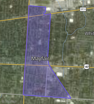
This property is located in Mayfair, Columbus, OH 43213.
Seasonal Housing units 43213
9%of housing is for seasonal rent.
Daytime Population for 43213
+14%of people during work hours.
Boundary map of Mayfair.
Crime Index for 43213
127
The crime index in 43213 is 127, which is 1.3 times higher than national average.
Market Trends
Historical market data near 678 Hampton Rd over selected time period.
Nearby Properties on Hampton Rd
- 549 S Hampton Rd, Columbus, OH 43213 (Mayfair) is a 854 square foot, 2 bedroom, 1 bathroom, 0.24 acre property. It was built in 1925 and has an estimate of $98,688 with a price per ft² of $116.
- 120 N Hampton Rd, Columbus, OH 43213 (Mayfair) is a 2,610 square foot, 4 bedroom, 4 bathroom, 0.24 acre property.
- 672 S Hampton Rd, Columbus, OH 43213 (Mayfair) is a 1,180 square foot, 4 bedroom, 2 bathroom, 0.11 acre property. It was built in 1941 and has an estimate of $153,750 with a price per ft² of $130.
- 548 S Hampton Rd, Columbus, OH 43213 (Mayfair) is a 1,256 square foot, 2 bedroom, 2.25 bathroom, 0.12 acre property. It was built in 1930 and has an estimate of $113,920 with a price per ft² of $91.
- 203 S Hampton Rd, Columbus, OH 43213 (Mayfair) is a 864 square foot, 3 bedroom, 1 bathroom, 0.17 acre property. It was built in 1951 and has an estimate of $135,016 with a price per ft² of $156.
- 34 S Hampton Rd, Columbus, OH 43213 (Mayfair) is a 1,120 square foot, 3 bedroom, 1 bathroom, 0.21 acre property. It was built in 1950 and has an estimate of $138,025 with a price per ft² of $123.
- 470 S Hampton Rd, Columbus, OH 43213 (Mayfair) is a 864 square foot, 3 bedroom, 1 bathroom, 0.16 acre property. It was built in 1951 and has an estimate of $103,786 with a price per ft² of $120.
- 506 S Hampton Rd, Columbus, OH 43213 (Mayfair) is a 864 square foot, 1 bedroom, 1 bathroom, 0.16 acre property. It was built in 1951 and has an estimate of $89,856 with a price per ft² of $104.
- 526 S Hampton Rd, Columbus, OH 43213 (Mayfair) is a 864 square foot, 3 bedroom, 1 bathroom, 0.17 acre property. It was built in 1950 and has an estimate of $121,750 with a price per ft² of $141.
- 212 S Hampton Rd, Columbus, OH 43213 (Mayfair) is a 864 square foot, 3 bedroom, 1 bathroom, 0.18 acre property. It was built in 1951 and has an estimate of $121,750 with a price per ft² of $141.
- 228 S Hampton Rd, Columbus, OH 43213 (Mayfair) is a 960 square foot, 3 bedroom, 1 bathroom, 0.18 acre property. It was built in 1951 and has an estimate of $138,250 with a price per ft² of $144.
- 236 S Hampton Rd, Columbus, OH 43213 (Mayfair) is a 1,056 square foot, 3 bedroom, 1 bathroom, 0.16 acre property. It was built in 1950 and has an estimate of $140,750 with a price per ft² of $133.
- 370 S Hampton Rd, Columbus, OH 43213 (Mayfair) is a 1,296 square foot, 4 bedroom, 1 bathroom, 0.17 acre property. It was built in 1950 and has an estimate of $116,640 with a price per ft² of $90.
- 378 S Hampton Rd, Columbus, OH 43213 (Mayfair) is a 1,384 square foot, 3 bedroom, 1 bathroom, 0.17 acre property. It was built in 1951 and has an estimate of $185,750 with a price per ft² of $134.
- 788-790 Hampton Rd, Columbus, OH 43227 (Mayfair) is a 1,920 square foot, 3 bedroom, 3.25 bathroom, 0.18 acre property. It was built in 1958 and has an estimate of $186,000 with a price per ft² of $97.
- 561 S Hampton Rd, Columbus, OH 43213 (Mayfair) is a 1,336 square foot, 3 bedroom, 1 bathroom, 0.11 acre property. It was built in 1900 and has an estimate of $146,750 with a price per ft² of $110.
- 1048 S Hampton Rd, Columbus, OH 43227 (East Hampton) is a 1,144 square foot, 3 bedroom, 1 bathroom, 0.14 acre property. It was built in 1952 and has an estimate of $148,250 with a price per ft² of $130.
- 130 N Hampton Rd, Columbus, OH 43213 (Mayfair) is a 1,696 square foot, 6 bedroom, 2 bathroom, 0.19 acre property. It was built in 1950 and has an estimate of $185,800 with a price per ft² of $110.
- 68 N Hampton Rd, Columbus, OH 43213 (Mayfair) is a 3,840 square foot, 8 bedroom, 4 bathroom, 0.19 acre property.
- 820 S Hampton Rd, Columbus, OH 43227 (Mayfair) is a 812 square foot, 2 bedroom, 1 bathroom, 0.17 acre property. It was built in 1955 and has an estimate of $117,520 with a price per ft² of $145.
- 65 S Hampton Rd # 71, Columbus, OH 43213 (Mayfair) is a 3,920 square foot and 2.76 acre property.
- 826 S Hampton Rd, Columbus, OH 43227 (Mayfair) is a 1,360 square foot, 3 bedroom, 2 bathroom, 0.14 acre property. It was built in 1955 and has an estimate of $180,250 with a price per ft² of $133.
- 781-783 Hampton Rd, Columbus, OH 43227 (Mayfair) is a 1,705 square foot, 4 bedroom, 2 bathroom, 0.11 acre property. It was built in 1958 and has an estimate of $159,800 with a price per ft² of $94.
- 885 S Hampton Rd, Columbus, OH 43227 (East Hampton) is a 984 square foot, 2 bedroom, 1 bathroom, 0.15 acre property.
- 1068 S Hampton Rd, Columbus, OH 43227 (East Hampton) is a 1,306 square foot, 4 bedroom, 1 bathroom, 0.14 acre property. It was built in 1952 and has an estimate of $166,250 with a price per ft² of $127.
- View more properties on Hampton Rd