9 High Dr
Spokane, WA 99203
- 4Beds
- 3Baths
- 2,953ft²Living Area
- 0.3acLot Size
- -Pool
- 4Car
- 1947Year Built
- -DOM
- 5Permits
Property Valuations
Latest estimates for 9 High Dr based on TopHap automated valuation model (AVM).
TopHap Estimate
$569,383
$192/ft²
Updated 3 months ago
9 High Dr is valued at $569,383 by TopHap AVM 3 months ago.
Permits
9 High Dr has 5 permit records of total value of $15,725.
Current Ownership
Information about the current owner(s).
Taxes Billed
Taxes billed in 2022$5,711.35From latest Total Assessed Value1.17%Total Assessed Value$488,800=Land+
Assessed Value$80,000Additions
Assessed Value$408,800
In 2022, taxes billed for 9 High Dr were $5,711.35, which is 1.17% from latest Total Assessed Value of $488,800.
Property History
9 High Dr has undefined property events records (listings, deeds, permits, tax, foreclosure, loan).
Environment
Environmental factors around 9 High Dr
Hazard Risks
Carb Mono169Lead155Air Pollution112Ozone110Nat'l Avg100Particulates82Earthquake68Wind3Hail2Hurricane0Tornado0Weather0
9 hazards (Carbon Monoxide, Earthquake Risk, Hail Index, Air Pollution Index, Ozone Index, Wind Index, Lead Index, Particulate Matter, National Average) are above the national average around 9 High Dr.
Walkability Index
13 /20
Most Walkable
20-18
Very Walkable
17-15
Somewhat Walkable
14-10
Car Dependent
9-0
9 High Dr has a walkability score of 13 out of 20, which means that it is in a somewhat walkable area.
Temperature
Seasonal temperature sampled over multiple years
Winter
Average
Low
23°F
High
36°F
Summer
Average
Low
51°F
High
81°F
In the winter at 9 High Dr, temperatures range from 23.3°F to 35.83°F with an average of 29.57°F. In the summer, the temperature ranges from 51.37°F to 80.71°F with and average of 66.04°F.
School Information
Public/private schools serving 9 High Dr
Public Schools
Nearby public schools serving 9 High Dr have ratings undefined, undefined, and undefined.
Neighborhood
This property is located in King, Spokane, WA 99203.
Seasonal Housing units 99203
9%of housing is for seasonal rent.
Daytime Population for 99203
-12%of people during work hours.
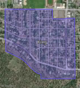
Boundary map of King.
Crime Index for 99203
72
The crime index in 99203 is 72, which is 0.7 times lower than national average.
Market Trends
Historical market data near 9 High Dr over selected time period.
Nearby Properties on High Dr
- 400 E High Dr, Spokane, WA 99203 (King) is a 3,908 square foot, 7 bedroom, 5.25 bathroom, 1.44 acre property. It was built in 1963 and has an estimate of $1,193,919 with a price per ft² of $306.
- 521 E High Dr, Spokane, WA 99203 (King) is a 1,426 square foot, 3 bedroom, 2 bathroom, 0.21 acre property. It was built in 2000 and has an estimate of $637,498 with a price per ft² of $447.
- 615 E High Dr, Spokane, WA 99203 (King) is a 1,248 square foot, 3 bedroom, 2 bathroom, 0.19 acre property. It was built in 2000 and has an estimate of $470,518 with a price per ft² of $377.
- 428 W High Dr, Spokane, WA 99203 (Comstock Park) is a 2,848 square foot, 5 bedroom, 5.5 bathroom, 0.34 acre property. It was built in 1990 and has an estimate of $1,470,956 with a price per ft² of $516.
- 405 E High Dr, Spokane, WA 99203 (King) is a 1,682 square foot, 4 bedroom, 3 bathroom, 0.15 acre property. It was built in 1950 and has an estimate of $598,352 with a price per ft² of $356.
- 408 W High Dr, Spokane, WA 99203 (Comstock Park) is a 3,174 square foot, 4 bedroom, 4.25 bathroom, 0.41 acre property. It was built in 1982 and has an estimate of $1,726,750 with a price per ft² of $544.
- 424 W High Dr, Spokane, WA 99203 (Comstock Park) is a 3,330 square foot, 5 bedroom, 4.25 bathroom, 0.36 acre property. It was built in 2000 and has an estimate of $1,434,410 with a price per ft² of $431.
- 518 E High Dr, Spokane, WA 99203 (King) is a 2,282 square foot, 1 bedroom, 4.25 bathroom, 0.65 acre property. It was built in 1941 and has an estimate of $865,495 with a price per ft² of $379.
- 308 W High Dr, Spokane, WA 99203 (Comstock Park) is a 2,196 square foot, 5 bedroom, 4.25 bathroom, 0.41 acre property. It was built in 2005 and has an estimate of $1,128,982 with a price per ft² of $514.
- 3111 S High Dr, Spokane, WA 99203 (High Drive) is a 3,273 square foot, 4 bedroom, 4.25 bathroom, 0.37 acre property. It was built in 1995 and has an estimate of $1,126,332 with a price per ft² of $344.
- 706 E High Dr, Spokane, WA 99203 is a 1,896 square foot, 3 bedroom, 3 bathroom, 0.25 acre property. It was built in 1985 and has an estimate of $822,073 with a price per ft² of $434.
- 3223 S High Dr, Spokane, WA 99203 (High Drive) is a 4,490 square foot, 4 bedroom, 4 bathroom, 0.37 acre property. It was built in 2001 and has an estimate of $1,423,862 with a price per ft² of $317.
- 330 E High Dr, Spokane, WA 99203 (King) is a 2,143 square foot, 5 bedroom, 2 bathroom, 0.9 acre property. It was built in 1941 and has an estimate of $926,005 with a price per ft² of $432.
- 702 E High Dr, Spokane, WA 99203 (Merritt Park) is a 1,981 square foot, 2 bedroom, 3 bathroom, 0.28 acre property. It was built in 1985 and has an estimate of $692,784 with a price per ft² of $350.
- 522 E High Dr, Spokane, WA 99203 (King) is a 2,490 square foot, 4 bedroom, 4 bathroom, 0.61 acre property. It was built in 2000 and has an estimate of $1,142,428 with a price per ft² of $459.
- 528 E High Dr, Spokane, WA 99203 (King) is a 3,039 square foot, 3 bedroom, 3 bathroom, 0.59 acre property. It was built in 1990 and has an estimate of $1,300,000 with a price per ft² of $428.
- 214 W High Dr, Spokane, WA 99203 (High Drive) is a 2,768 square foot, 3 bedroom, 3.25 bathroom, 0.38 acre property. It was built in 1975 and has an estimate of $1,164,745 with a price per ft² of $421.
- 130 W High Dr, Spokane, WA 99203 (High Drive) is a 2,372 square foot, 4 bedroom, 4.25 bathroom, 0.42 acre property. It was built in 1979 and has an estimate of $1,198,426 with a price per ft² of $505.
- 505 E High Dr, Spokane, WA 99203 (King) is a 1,720 square foot, 3 bedroom, 2.25 bathroom, 0.2 acre property. It was built in 1948 and has an estimate of $450,877 with a price per ft² of $262.
- 230 E High Dr, Spokane, WA 99203 (King) is a 3,315 square foot, 4 bedroom, 4 bathroom, 1.04 acre property. It was built in 1985 and has an estimate of $1,398,413 with a price per ft² of $422.
- 3239 S High Dr, Spokane, WA 99203 (High Drive) is a 2,521 square foot, 5 bedroom, 4.25 bathroom, 0.4 acre property. It was built in 1990 and has an estimate of $1,234,100 with a price per ft² of $490.
- 130 E High Dr, Spokane, WA 99203 (King) is a 3,170 square foot, 6 bedroom, 4.25 bathroom, 0.87 acre property. It was built in 2000 and has an estimate of $2,063,823 with a price per ft² of $651.
- 3103 S High Dr, Spokane, WA 99203 (High Drive) is a 2,680 square foot, 4 bedroom, 4.25 bathroom, 0.38 acre property. It was built in 2000 and has an estimate of $1,172,533 with a price per ft² of $438.
- 119 E High Dr, Spokane, WA 99203 (King) is a 2,664 square foot, 5 bedroom, 3 bathroom, 0.38 acre property. It was built in 1960 and has an estimate of $919,562 with a price per ft² of $345.
- 3611 S High Dr, Spokane, WA 99203 (Comstock Park) is a 6,254 square foot, 8 bedroom, 4.25 bathroom, 0.39 acre property. It was built in 1990 and has an estimate of $1,439,212 with a price per ft² of $230.
- View more properties on High Dr