?
  • Chat with Us
  • Submit Feedback
  • TopHap Academy
  • What's New?
Land > Farm / Agriculture
Sold
08/27/2021
Sold Price
$--$--/ft²

10450 Mcdonald Rd
Stockton, CA 95206

10450 Mcdonald Rd, Stockton, CA 95206 is a farm/agriculture land of 313.790 acres with 20 construction permits. This farm/agriculture is currently off market, and it was last sold in 2021.

Permits

10450 Mcdonald Rd has 20 permit records.

Permit History
20
Permits
March 15, 2022
Description: New gas service for ag pumpStatus: issuedType: Over the counter permitSub Type: Pumpserv: pump serviceApplicant: Gallo, Robert J Lf EstFees: $209Effective Date: 2022-03-15Permit Number: BP-2201102
January 21, 2021
Description: ExcavationStatus: appliedType: Psproj psproj: bp clearance/release form ps: pw - public serviceFees: $2,639Effective Date: 2021-01-21Permit Number: PS-2100181
January 15, 2021
Description: N/aStatus: appliedType: Ps dw: driveway encroachment ps: pw - public serviceFees: $275Effective Date: 2021-01-15Permit Number: PS-2100159
December 11, 2020
Description: Referral: an improvement plan for previously approved quarry excavation pa-1900177 to remove 176, 500 cubic yards of sand in two (2) phases within four (4) years to include excavation and reclamation for farming purposes. The project excavation and reclamation will occur on 9.1-acres of a 313.79-acre parcel. The removal of the sand streak within this area is to increase the agricultural viability of the parcel for final reclamation to orchards. Excavation will not exceed a maximum depth of twelve (12) feet. The excavated area will be consistent with the existing field elevations surrounding the project site once reclaimed. The parcel has direct access from west mcdonald road and is under a williamson act contract. (this application was previously referred out as a pre-application and is now a full-application with revised phasing and a revised reclamation plan) *** location: on the south side of the intersection of west mcdonald road and west davini road west of stockton. *** use type:Status: filedType: Planning ip: improvement plan plan: cdd - planningFees: $433Effective Date: 2020-12-11Permit Number: PA-2000219
July 26, 2019
Description: Referral: a quarry excavation application to remove 176, 500 cubic yards of sand in two (2) phases within four (4) years to include excavation and reclamation for farming purposes. The project excavation and reclamation will occur on 9.1-acres of a 313.79-acre parcel. The removal of the sand streak within this area is to increase the agricultural viability of the parcel for final reclamation to orchards. Excavation will not exceed a maximum depth of twelve (12) feet. The excavated area will be consistent with the existing field elevations surrounding the project site once reclaimed. The parcel has direct access from west mcdonald road and is under a williamson act contract. (this application was previously referred out as a pre-application and is now a full-application with revised phasing and a revised reclamation plan) *** location: on the south side of the intersection of west mcdonald road and west davini road east of stockton. *** use type: quarry excavation *** history: dp-88-001Status: filedType: Planning qx: quarry excavation plan: cdd - planningFees: $10,391Effective Date: 2019-07-26Permit Number: PA-1900177
March 3, 2009
Description: N/aStatus: filedType: PWAGREE, PW-AG: Ag - ExcavationBusiness Name: REEVES SAND & GRAVEL, INCFees: $7,128Effective Date: 2009-03-03Permit Number: YR-0900005
November 5, 2008
Description: Pa-0800111 - agricultural excavationStatus: RELEASEType: Psproj psproj: bp clearance/release formBusiness Name: REEVES SAND & GRAVEL, INCFees: $2,070Effective Date: 2008-11-05Permit Number: PS-0803446
November 4, 2008
Description: Referral: ip- improvement plan for ag excavation *** ip is tied to pa-0800111Status: finalType: Planning ip: improvement planBusiness Name: REEVES, ROYFees: $355Effective Date: 2008-11-04Permit Number: PA-0800346
September 26, 2008
Description: N/aStatus: issuedType: PS, DW: Driveway EncroachmentBusiness Name: REEVES SAND & GRAVEL, INCFees: $192Effective Date: 2008-09-26Permit Number: PS-0803102
March 26, 2008
Description: AE: AGRICULTURAL EXCAVATION APPLICATION FOR THE EXCAVATION AND REMOVAL OF 99,000 CUBIC YARDS OF SOIL TO BE COMPLETED BY MAY 1, 2010 *** LOCATION: ON THE SOUTH SIDE OF MCDONALD RD, 1400' EAST OF DAVINI RD, W/O STOCKTON *** HISTORY: CS-02-0599, FA-00-0011, IP-97-0001, IP-99-0006, IP-99-0035, PA-0700138, QX-98-0002 *** AGRICULTURAL EXCAVATION *** APPROVED USE: This approval is for the excavation and removal of 99,000 cubic yards of topsoil from a 29.0 acre site, in two phases. Phase 1 to be completed within 18 months from the date of approval, includes the following: removal of 12 acres of sand totaling 99,000 cubic yards, removal of 2 feet of heavy soil totaling 39,000 cubic yards that will be added back as a part of the phase 2 reclamation processes. Phase 2 to be completed within 36 months from the date of approval includes the following: The removal of 17 acres of heavy top soil totaling 55,000 cubic yards of which includes the 39,000 cubic yards in phase 1, and the remaining 11,000 cStatus: finalType: PLANNING, AE: Agricultural ExcavationBusiness Name: REEVES SAND & GRAVEL, INCFees: $2,519Effective Date: 2008-03-26Permit Number: PA-0800111
April 3, 2007
Description: Require fire permit for pa-0700138Status: finalType: Fire fire: cdd - fireBusiness Name: ABA ENERGYFees: $95Effective Date: 2007-04-03Permit Number: FP-0700141
March 28, 2007
Description: Ip- to drill a natural gas well (gallo #1) *** location; on the south side of mcdonald rd 1400 east of davini rd well location 400 south & 1350 east from the n/w corner of section 9 t1n r5e san joaquin county *** improvement planStatus: FINALType: Planning ip: improvement planBusiness Name: ABA ENERGYFees: $323Effective Date: 2007-03-28Permit Number: PA-0700138
October 18, 2000
Description: WILLIAMSON ACT RESCISSION Reference FA-00-0011 with: FZ-00-0013, RS-00-0019, RS-00-0020, RS-00-0021Status: finalType: RS, PLAN: CDD - PlanningBusiness Name: TORLAI, GREG & LAURA ETALFees: $100Effective Date: 2000-10-18Permit Number: RS-00-0019
October 18, 2000
Description: FARM LAND SECURITY ZONE 01-23-2001 Reference FA-00-0011 with: FZ-00-0013, RS-00-0019, RS-00-0020, RS-00-0021 Readied for MICROFILMING -LMStatus: finalType: FZ, PLAN: CDD - PlanningBusiness Name: TORLAI, GREG & LAURA ETALFees: $282Effective Date: 2000-10-18Permit Number: FZ-00-0013
October 18, 2000
Description: FARMLAND SECURITY CONTRACT Reference FA-00-0011 with: FZ-00-0013, RS-00-0019, RS-00-0020, RS-00-0021Status: finalType: FA, PLAN: CDD - PlanningBusiness Name: TORLAI, GREG & LAURA ETALFees: $270Effective Date: 2000-10-18Permit Number: FA-00-0011
June 28, 1999
Description: IP: FOR QUARRY EXCAVATION NO. QX-98-2 * LOCATION: ON THE SOUTH SIDE OF McDONALD RD, 2400 FEET WEST OF HOLT RD, WEST OF STOCKTON. ***IMPROVEMENT PLANStatus: finalType: IP, PLAN: CDD - PlanningBusiness Name: ROY REEVES0Effective Date: 1999-06-28Permit Number: IP-99-0035
February 11, 1999
Description: Improvement plan for qx-98-2Status: finalType: Ip plan: cdd - planningBusiness Name: REEVES, ROY0Effective Date: 1999-02-11Permit Number: IP-99-0006
September 8, 1998
Description: Revisions of approved action to re-excavate eleven acres of an existing quarry and to reclaim the land into two fish ponds for raising of fish for food consumption. 560, 000 cu yards of material to be removed ***** location: on the south side of mc donald island road one mile west of holt road west of stockton supercedes gx-96-6/ip-97-1 application. -----quarry excavation ------- note: revisions of approved actions submitted 2/25/99 requesting time extension to increase the amount of performance gaurantee bond now in place. ***** (2nd) revision of approved actions 2-4-03: applicant withdrew revisions of actions requestStatus: APPROVEDType: Qx ds: conversionBusiness Name: Michael FarleyFees: $5,509Effective Date: 1998-09-08Permit Number: QX-98-0002
January 7, 1997
Description: Improvement plan for gx-96-6 agricultural exca- vation for 314 acres. **** located on the south side of mcdonald rd 1/2 milewest of holt rd west of stocktonStatus: approvedType: Ip ds: conversionBusiness Name: REEVES SAND AND TOPSOILFees: $130Effective Date: 1997-01-07Permit Number: IP-97-0001
September 27, 1996
Description: An agricultural excavation permit for a 314 acre site. ******* location: located on the south side of mc donald road 1/2 mile west of holt road west of stocktonStatus: approvedType: Gx ds: conversionBusiness Name: REEVES, ROYFees: $1,505Effective Date: 1996-09-27Permit Number: GX-96-0006

Current Ownership

Information about the current owner(s).

Property History

10450 Mcdonald Rd has undefined property events records (listings, deeds, permits, tax, foreclosure, loan).

Property Events

Environment

Environmental factors around 10450 Mcdonald Rd

School Information

Public/private schools serving 10450 Mcdonald Rd

Neighborhood

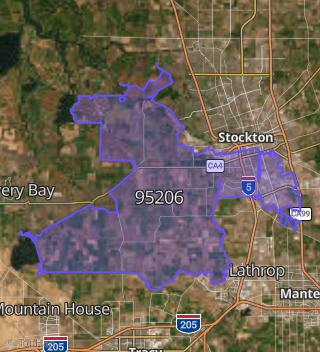
This property is located in 95206.
Market Trends

Historical market data near 10450 Mcdonald Rd over selected time period.

Nearby Properties on Mcdonald Rd