114 Doe Ct
Fremont, CA 94539
- 4Beds
- 3Baths
- 1,728ft²Living Area
- 6,000ft²Lot Size
- -Pool
- -Car
- 1988Year Built
- -DOM
- 7Permits
Property Valuations
Latest estimates for 114 Doe Ct based on TopHap automated valuation model (AVM).
TopHap Estimate
$1,777,250
$1,028/ft²
+$928K above Sold Price
Updated 3 months ago
Last Sold Price
$849,000
$491/ft²
16 years ago
114 Doe Ct is valued at $1,777,250 by TopHap AVM 3 months ago.
114 Doe Ct was last sold in 2008 for $849,000.
Permits
114 Doe Ct has 7 permit records.
Current Ownership
Information about the current owner(s).
Taxes Billed
Taxes billed in 2023$12,785.80From latest Total Assessed Value1.19%Total Assessed Value$1,071,811=Land+
Assessed Value$321,543Additions
Assessed Value$750,268
In 2023, taxes billed for 114 Doe Ct were $12,785.8, which is 1.19% from latest Total Assessed Value of $1,071,811.
Property History
114 Doe Ct has undefined property events records (listings, deeds, permits, tax, foreclosure, loan).
Environment
Environmental factors around 114 Doe Ct
Hazard Risks
Earthquake683Particulates107Nat'l Avg100Carb Mono94Ozone89Air Pollution87Lead40Tornado16Weather7Wind2Hail0Hurricane0
10 hazards (Carbon Monoxide, Earthquake Risk, Tornado Index, Air Pollution Index, Ozone Index, Wind Index, Weather Risk, Lead Index, Particulate Matter, National Average) are above the national average around 114 Doe Ct.
Walkability Index
11 /20
Most Walkable
20-18
Very Walkable
17-15
Somewhat Walkable
14-10
Car Dependent
9-0
114 Doe Ct has a walkability score of 11 out of 20, which means that it is in a somewhat walkable area.
Noise Level
41 dB
Quiet Suburban Residential 0-49
Suburban Residential 50-54
Urban Residential 55-59
Noisy Urban Residential 60-64
Very Noisy Urban Residential 65+
Noise at 114 Doe Ct is around 41dBs, which is comparable to a Quiet Suburban Residential area.
Temperature
Seasonal temperature sampled over multiple years
Winter
Average
Low
41°F
High
58°F
Summer
Average
Low
55°F
High
81°F
In the winter at 114 Doe Ct, temperatures range from 41.05°F to 58.01°F with an average of 49.53°F. In the summer, the temperature ranges from 54.69°F to 80.61°F with and average of 67.65°F.
School Information
Public/private schools serving 114 Doe Ct
Public Schools
Nearby public schools serving 114 Doe Ct have ratings undefined, undefined, and undefined.
Neighborhood
This property is located in Mission Hills, Fremont, CA 94539.
Seasonal Housing units 94539
18%of housing is for seasonal rent.
Daytime Population for 94539
+10%of people during work hours.
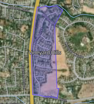
Boundary map of Mission Hills.
Crime Index for 94539
18
The crime index in 94539 is 18, which is 0.2 times lower than national average.
Market Trends
Historical market data near 114 Doe Ct over selected time period.
Nearby Properties on Doe Ct
- 177 Doe Ct, Fremont, CA 94539 (Vineyard Hills) is a 1,960 square foot, 4 bedroom, 3.25 bathroom, 0.1 acre property. It was built in 1988 and has an estimate of $1,661,221 with a price per ft² of $848.
- 126 Doe Ct, Fremont, CA 94539 (Vineyard Hills) is a 1,484 square foot, 2 bedroom, 3.25 bathroom, 0.11 acre property. It was built in 1988 and has an estimate of $1,252,874 with a price per ft² of $844.
- 129 Doe Ct, Fremont, CA 94539 (Vineyard Hills) is a 1,960 square foot, 4 bedroom, 2.5 bathroom, 0.11 acre property. It was built in 1988 and has an estimate of $1,656,200 with a price per ft² of $845.
- 114 Doe Ct, Fremont, CA 94539 (Vineyard Hills) is a 1,728 square foot, 4 bedroom, 3 bathroom, 0.14 acre property. It was built in 1988 and has an estimate of $1,291,730 with a price per ft² of $748.
- 165 Doe Ct, Fremont, CA 94539 (Vineyard Hills) is a 1,960 square foot, 4 bedroom, 3.25 bathroom, 0.07 acre property. It was built in 1988 and has an estimate of $1,688,081 with a price per ft² of $861.
- 138 Doe Ct, Fremont, CA 94539 (Vineyard Hills) is a 1,484 square foot, 2 bedroom, 3.25 bathroom, 0.11 acre property. It was built in 1988 and has an estimate of $1,235,556 with a price per ft² of $833.
- 162 Doe Ct, Fremont, CA 94539 (Vineyard Hills) is a 1,960 square foot, 4 bedroom, 3.25 bathroom, 0.1 acre property. It was built in 1988 and has an estimate of $1,682,574 with a price per ft² of $858.
- 105 Doe Ct, Fremont, CA 94539 (Vineyard Hills) is a 1,728 square foot, 4 bedroom, 3 bathroom, 0.23 acre property. It was built in 1989 and has an estimate of $1,653,179 with a price per ft² of $957.
- 117 Doe Ct, Fremont, CA 94539 (Vineyard Hills) is a 1,960 square foot, 4 bedroom, 3.25 bathroom, 0.08 acre property. It was built in 1988 and has an estimate of $1,613,159 with a price per ft² of $823.
- 141 Doe Ct, Fremont, CA 94539 (Vineyard Hills) is a 1,728 square foot, 4 bedroom, 3.25 bathroom, 0.09 acre property. It was built in 1988 and has an estimate of $1,553,202 with a price per ft² of $899.
- 153 Doe Ct, Fremont, CA 94539 (Vineyard Hills) is a 1,728 square foot, 4 bedroom, 3.25 bathroom, 0.08 acre property. It was built in 1988 and has an estimate of $1,594,968 with a price per ft² of $923.
- 174 Doe Ct, Fremont, CA 94539 (Vineyard Hills) is a 1,728 square foot, 3 bedroom, 3 bathroom, 0.13 acre property. It was built in 1988 and has an estimate of $1,500,745 with a price per ft² of $868.
- 150 Doe Ct, Fremont, CA 94539 (Vineyard Hills) is a 1,960 square foot, 3 bedroom, 2.5 bathroom, 0.1 acre property. It was built in 1988 and has an estimate of $1,666,910 with a price per ft² of $850.
- 102 Doe Ct, Fremont, CA 94539 (Vineyard Hills) is a 1,728 square foot, 3 bedroom, 3 bathroom, 0.13 acre property. It was built in 1988 and has an estimate of $1,562,709 with a price per ft² of $904.