118 Hubbard St
Santa Cruz, CA 95060
- -Bed
- -Bath
- -Living Area
- 7,415ft²Lot Size
- -Pool
- -Car
- -Year Built
- -DOM
- -Permit
Current Ownership
Information about the current owner(s).
Taxes Billed
Taxes billed in 2023$5,193.84From latest Total Assessed Value1.22%Total Assessed Value$424,410=Land+
Assessed Value$420,997Additions
Assessed Value$3,413
In 2023, taxes billed for 118 Hubbard St were $5,193.84, which is 1.22% from latest Total Assessed Value of $424,410.
Property History
118 Hubbard St has undefined property events records (listings, deeds, permits, tax, foreclosure, loan).
Environment
Environmental factors around 118 Hubbard St
Hazard Risks
Earthquake359Nat'l Avg100Particulates98Air Pollution80Ozone78Carb Mono61Lead43Tornado6Weather1Hail0Hurricane0Wind0
9 hazards (Carbon Monoxide, Earthquake Risk, Tornado Index, Air Pollution Index, Ozone Index, Weather Risk, Lead Index, Particulate Matter, National Average) are above the national average around 118 Hubbard St.
Walkability Index
17 /20
Most Walkable
20-18
Very Walkable
17-15
Somewhat Walkable
14-10
Car Dependent
9-0
118 Hubbard St has a walkability score of 17 out of 20, which means that it is in a very walkable area.
Temperature
Seasonal temperature sampled over multiple years
Winter
Average
Low
41°F
High
60°F
Summer
Average
Low
52°F
High
75°F
In the winter at 118 Hubbard St, temperatures range from 41.25°F to 59.72°F with an average of 50.49°F. In the summer, the temperature ranges from 52.28°F to 75.09°F with and average of 63.69°F.
School Information
Public/private schools serving 118 Hubbard St
Public Schools
Nearby public schools serving 118 Hubbard St have ratings undefined, undefined, and undefined.
Neighborhood
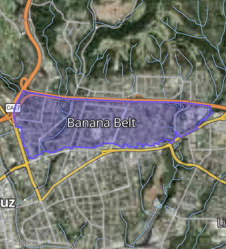
This property is located in Banana Belt, Santa Cruz, CA 95060.
Seasonal Housing units 95060
28%of housing is for seasonal rent.
Daytime Population for 95060
+12%of people during work hours.
Boundary map of Banana Belt.
Crime Index for 95060
121
The crime index in 95060 is 121, which is 1.2 times higher than national average.
Market Trends
Historical market data near 118 Hubbard St over selected time period.
Nearby Properties on Hubbard St
- 117 Hubbard St, Santa Cruz, CA 95060 (Banana Belt) is a 546 square foot, 2 bedroom, 1 bathroom, 0.16 acre property. It was built in 1910 and has an estimate of $696,474 with a price per ft² of $1,276.
- 113 Hubbard St, Santa Cruz, CA 95060 (Banana Belt) is a 896 square foot, 2 bedroom, 1 bathroom, 0.14 acre property. It was built in 1983 and has an estimate of $857,209 with a price per ft² of $957.
- 109 Hubbard St, Santa Cruz, CA 95060 (Banana Belt) is a 945 square foot, 2 bedroom, 1 bathroom, 0.12 acre property. It was built in 1920 and has an estimate of $1,028,115 with a price per ft² of $1,088.
- 208 Hubbard St, Santa Cruz, CA 95060 (Banana Belt) is a 2,830 square foot, 6 bedroom, 5 bathroom, 0.17 acre property. It was built in 1990 and has an estimate of $1,574,179 with a price per ft² of $556.
- 220 Hubbard St, Santa Cruz, CA 95060 (Banana Belt) is a 1,698 square foot, 3 bedroom, 2 bathroom, 0.13 acre property. It was built in 2001 and has an estimate of $1,230,110 with a price per ft² of $724.
- 204 Hubbard St, Santa Cruz, CA 95060 (Banana Belt) is a 3,165 square foot, 6 bedroom, 5 bathroom, 0.19 acre property. It was built in 1991 and has an estimate of $1,634,932 with a price per ft² of $517.
- 212 Hubbard St, Santa Cruz, CA 95060 (Banana Belt) is a 3,177 square foot, 6 bedroom, 7.5 bathroom, 0.16 acre property. It was built in 1990 and has an estimate of $1,498,090 with a price per ft² of $472.
- 209 Hubbard St, Santa Cruz, CA 95060 (Banana Belt) is a 1,260 square foot, 3 bedroom, 1 bathroom, 0.11 acre property. It was built in 1961 and has an estimate of $1,108,753 with a price per ft² of $880.
- 215 Hubbard St, Santa Cruz, CA 95060 (Banana Belt) is a 864 square foot, 2 bedroom, 1 bathroom, 0.12 acre property. It was built in 1970 and has an estimate of $1,006,541 with a price per ft² of $1,165.
- 129 Hubbard St, Santa Cruz, CA 95060 (Banana Belt) is a 3,392 square foot, 8 bedroom, 4 bathroom, 0.14 acre property. It was built in 1977 and has an estimate of $1,359,857 with a price per ft² of $401.
- 125 Hubbard St, Santa Cruz, CA 95060 (Banana Belt) is a 3,392 square foot, 8 bedroom, 4 bathroom, 0.14 acre property. It was built in 1977 and has an estimate of $1,359,857 with a price per ft² of $401.
- 121 Hubbard St, Santa Cruz, CA 95060 (Banana Belt) is a 1,695 square foot, 3 bedroom, 2 bathroom, 0.17 acre property. It was built in 1888 and has an estimate of $1,241,744 with a price per ft² of $733.
- 207 Hubbard St, Santa Cruz, CA 95060 (Glenwood) is a 1,344 square foot, 3 bedroom, 1 bathroom, 0.12 acre property. It was built in 1900 and has an estimate of $971,920 with a price per ft² of $723.
- 203 Hubbard St, Santa Cruz, CA 95060 (Glenwood) is a 2,476 square foot, 3 bedroom, 3 bathroom, 0.12 acre property. It was built in 1898 and has an estimate of $1,336,943 with a price per ft² of $540.
- 221 Hubbard St, Santa Cruz, CA 95060 (Banana Belt) is a 1,520 square foot, 2 bedroom, 2 bathroom, 0.12 acre property. It was built in 1961 and has an estimate of $1,077,056 with a price per ft² of $709.
- 122 Hubbard St, Santa Cruz, CA 95060 (Banana Belt) is a 4,480 square foot and 0.14 acre property.
- 126 Hubbard St, Santa Cruz, CA 95060 (Banana Belt) is a 0.14 acre property.
- 130 Hubbard St, Santa Cruz, CA 95060 (Banana Belt) is a 2,400 square foot and 0.14 acre property.
- 116 Hubbard St, Santa Cruz, CA 95060 (Banana Belt) is a 2,549 square foot, 1 bedroom, 1 bathroom, 0.11 acre property.
- 118 Hubbard St, Santa Cruz, CA 95060 (Banana Belt) is a 0.17 acre property.
- 217 Hubbard St, Santa Cruz, CA 95060 (Banana Belt) is a 1,411 square foot, 3 bedroom, 3 bathroom, 0.16 acre property. It was built in 1971 and has an estimate of $1,121,794 with a price per ft² of $795.