1230 Manitou Ln
Santa Barbara, CA 93101
- 3Beds
- 3Baths
- 2,825ft²Living Area
- 1.4acLot Size
- -Pool
- -Car
- 1964Year Built
- -DOM
- -Permit
Property Valuations
Latest estimates for 1230 Manitou Ln based on TopHap automated valuation model (AVM).
TopHap Estimate
$5,354,000
$1,895/ft²
+$4M above Sold Price
Updated 3 months ago
Last Sold Price
$1,050,000
$372/ft²
13 years ago
1230 Manitou Ln is valued at $5,354,000 by TopHap AVM 3 months ago.
1230 Manitou Ln was last sold in 2010 for $1,050,000.
Current Ownership
Information about the current owner(s).
Taxes Billed
Taxes billed in 2023$13,663.70From latest Total Assessed Value1.06%Total Assessed Value$1,292,989=Land+
Assessed Value$677,280Additions
Assessed Value$615,709
In 2023, taxes billed for 1230 Manitou Ln were $13,663.7, which is 1.06% from latest Total Assessed Value of $1,292,989.
Property History
1230 Manitou Ln has undefined property events records (listings, deeds, permits, tax, foreclosure, loan).
Environment
Environmental factors around 1230 Manitou Ln
Hazard Risks
Earthquake451Particulates101Nat'l Avg100Ozone100Lead98Carb Mono95Air Pollution94Tornado8Weather4Hurricane2Wind1Hail0
11 hazards (Carbon Monoxide, Earthquake Risk, Tornado Index, Hurricane Index, Air Pollution Index, Ozone Index, Wind Index, Weather Risk, Lead Index, Particulate Matter, National Average) are above the national average around 1230 Manitou Ln.
Walkability Index
11 /20
Most Walkable
20-18
Very Walkable
17-15
Somewhat Walkable
14-10
Car Dependent
9-0
1230 Manitou Ln has a walkability score of 11 out of 20, which means that it is in a somewhat walkable area.
Temperature
Seasonal temperature sampled over multiple years
Winter
Average
Low
43°F
High
65°F
Summer
Average
Low
56°F
High
74°F
In the winter at 1230 Manitou Ln, temperatures range from 43.29°F to 64.77°F with an average of 54.03°F. In the summer, the temperature ranges from 55.64°F to 73.59°F with and average of 64.62°F.
School Information
Public/private schools serving 1230 Manitou Ln
Public Schools
Nearby public schools serving 1230 Manitou Ln have ratings undefined, undefined, and undefined.
Neighborhood
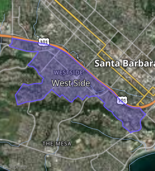
This property is located in West Side, Santa Barbara, CA 93101.
Seasonal Housing units 93101
22%of housing is for seasonal rent.
Daytime Population for 93101
+36%of people during work hours.
Boundary map of West Side.
Crime Index for 93101
135
The crime index in 93101 is 135, which is 1.4 times higher than national average.
Market Trends
Historical market data near 1230 Manitou Ln over selected time period.
Nearby Properties on Manitou Ln
- 1229 Manitou Ln, Santa Barbara, CA 93101 (West Side) is a 4,026 square foot, 4 bedroom, 4.25 bathroom, 0.69 acre property. It was built in 2006 and has an estimate of $3,698,348 with a price per ft² of $919.
- 1225 Manitou Ln, Santa Barbara, CA 93101 (West Side) is a 3,855 square foot, 4 bedroom, 4.25 bathroom, 1.42 acre property. It was built in 2006 and has an estimate of $4,194,186 with a price per ft² of $1,088.
- 1223 Manitou Ln, Santa Barbara, CA 93101 (West Side) is a 3,261 square foot, 4 bedroom, 3 bathroom, 0.29 acre property. It was built in 2004 and has an estimate of $2,390,936 with a price per ft² of $733.
- 1221 Manitou Ln, Santa Barbara, CA 93101 (West Side) is a 2,505 square foot, 2 bedroom, 3.25 bathroom, 0.45 acre property. It was built in 2004 and has an estimate of $2,636,091 with a price per ft² of $1,052.
- 1227 Manitou Ln, Santa Barbara, CA 93101 (West Side) is a 2,919 square foot, 4 bedroom, 3 bathroom, 0.7 acre property. It was built in 2006 and has an estimate of $3,309,104 with a price per ft² of $1,134.
- 1231 Manitou Ln, Santa Barbara, CA 93101 (West Side) is a 3,790 square foot, 3 bedroom, 5.25 bathroom, 0.74 acre property. It was built in 2006 and has an estimate of $3,924,453 with a price per ft² of $1,035.
- 1233 Manitou Ln, Santa Barbara, CA 93101 (West Side) is a 2,282 square foot, 3 bedroom, 2 bathroom, 1.31 acre property. It was built in 1960 and has an estimate of $2,546,510 with a price per ft² of $1,116.
- 1228 Manitou Ln, Santa Barbara, CA 93101 (West Side) is a 2,467 square foot, 3 bedroom, 4.25 bathroom, 0.6 acre property. It was built in 1960 and has an estimate of $2,734,557 with a price per ft² of $1,108.
- 1222 Manitou Ln, Santa Barbara, CA 93101 (West Side) is a 2,779 square foot, 3 bedroom, 3.25 bathroom, 0.16 acre property. It was built in 1998 and has an estimate of $2,031,601 with a price per ft² of $731.
- 1224 Manitou Ln, Santa Barbara, CA 93101 (West Side) is a 2,366 square foot, 4 bedroom, 4 bathroom, 0.5 acre property. It was built in 1957 and has an estimate of $2,234,188 with a price per ft² of $944.
- 1230 Manitou Ln, Santa Barbara, CA 93101 (West Side) is a 2,825 square foot, 3 bedroom, 3.25 bathroom, 1.42 acre property. It was built in 1964 and has an estimate of $3,622,187 with a price per ft² of $1,282.
- 1226 Manitou Ln, Santa Barbara, CA 93101 (West Side) is a 2,371 square foot, 3 bedroom, 3.25 bathroom, 0.99 acre property. It was built in 1998 and has an estimate of $2,841,307 with a price per ft² of $1,198.