1234 P St
Livermore, CA 94551
- 4Beds
- 2Baths
- 1,404ft²Living Area
- 5,320ft²Lot Size
- 1Pool
- -Car
- 1956Year Built
- -DOM
- 6Permits
Property Valuations
Latest estimates for 1234 P St based on TopHap automated valuation model (AVM).
TopHap Estimate
$1,004,750
$715/ft²
+$405K above Sold Price
Updated 3 months ago
Last Sold Price
$600,000
$427/ft²
9 years ago
1234 P St is valued at $1,004,750 by TopHap AVM 3 months ago.
1234 P St was last sold in 2015 for $600,000.
Permits
1234 P St has 6 permit records of total value of $5,000.
Current Ownership
Information about the current owner(s).
Taxes Billed
Taxes billed in 2023$9,036.38From latest Total Assessed Value1.3%Total Assessed Value$693,090=Land+
Assessed Value$207,927Additions
Assessed Value$485,163
In 2023, taxes billed for 1234 P St were $9,036.38, which is 1.30% from latest Total Assessed Value of $693,090.
Property History
1234 P St has undefined property events records (listings, deeds, permits, tax, foreclosure, loan).
Environment
Environmental factors around 1234 P St
Hazard Risks
Earthquake382Particulates105Nat'l Avg100Air Pollution85Ozone82Carb Mono81Lead40Tornado10Wind9Weather6Hail0Hurricane0
10 hazards (Carbon Monoxide, Earthquake Risk, Tornado Index, Air Pollution Index, Ozone Index, Wind Index, Weather Risk, Lead Index, Particulate Matter, National Average) are above the national average around 1234 P St.
Walkability Index
16 /20
Most Walkable
20-18
Very Walkable
17-15
Somewhat Walkable
14-10
Car Dependent
9-0
1234 P St has a walkability score of 16 out of 20, which means that it is in a very walkable area.
Noise Level
54 dB
Quiet Suburban Residential 0-49
Suburban Residential 50-54
Urban Residential 55-59
Noisy Urban Residential 60-64
Very Noisy Urban Residential 65+
Noise at 1234 P St is around 54dBs, which is comparable to a Suburban Residential area.
Temperature
Seasonal temperature sampled over multiple years
Winter
Average
Low
39°F
High
57°F
Summer
Average
Low
54°F
High
85°F
In the winter at 1234 P St, temperatures range from 39.27°F to 56.94°F with an average of 48.11°F. In the summer, the temperature ranges from 53.95°F to 84.68°F with and average of 69.32°F.
School Information
Public/private schools serving 1234 P St
Public Schools
Nearby public schools serving 1234 P St have ratings undefined, undefined, and undefined.
Neighborhood
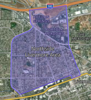
This property is located in Northside Livermore Area, Livermore, CA 94551.
Seasonal Housing units 94551
15%of housing is for seasonal rent.
Daytime Population for 94551
+16%of people during work hours.
Boundary map of Northside Livermore Area.
Crime Index for 94551
62
The crime index in 94551 is 62, which is 0.6 times lower than national average.
Market Trends
Historical market data near 1234 P St over selected time period.
Nearby Properties on P St
- 1221 N P St, Livermore, CA 94551 (Northside Livermore Area) is a 1,996 square foot, 5 bedroom, 2 bathroom, 0.13 acre property. It was built in 1956 and has an estimate of $830,566 with a price per ft² of $416.
- 1050 N P St, Livermore, CA 94551 (Northside Livermore Area) is a 1,172 square foot, 3 bedroom, 2 bathroom, 0.12 acre property. It was built in 1955 and has an estimate of $922,257 with a price per ft² of $787.
- 386 S P St, Livermore, CA 94550 (Southside Livermore) is a 946 square foot, 3 bedroom, 1 bathroom, 0.11 acre property. It was built in 1950 and has an estimate of $891,462 with a price per ft² of $942.
- 1234 N P St, Livermore, CA 94551 (Northside Livermore Area) is a 1,404 square foot, 4 bedroom, 2 bathroom, 0.12 acre property. It was built in 1956 and has an estimate of $973,955 with a price per ft² of $694.
- 463 N P St, Livermore, CA 94551 (Northside Livermore Area) is a 1,346 square foot, 3 bedroom, 2 bathroom, 0.11 acre property. It was built in 1989 and has an estimate of $853,744 with a price per ft² of $634.
- 712 N P St, Livermore, CA 94551 (Northside Livermore Area) is a 1,120 square foot, 4 bedroom, 1 bathroom, 0.11 acre property. It was built in 1900 and has an estimate of $613,124 with a price per ft² of $547.
- 640 N P St, Livermore, CA 94551 (Northside Livermore Area) is a 2,024 square foot, 5 bedroom, 4 bathroom, 0.17 acre property. It was built in 1980 and has an estimate of $1,124,247 with a price per ft² of $555.
- 953 N P St, Livermore, CA 94551 (Northside Livermore Area) is a 1,172 square foot, 3 bedroom, 2 bathroom, 0.12 acre property. It was built in 1955 and has an estimate of $886,373 with a price per ft² of $756.
- 1363 N P St, Livermore, CA 94551 (Northside Livermore Area) is a 1,664 square foot, 4 bedroom, 2 bathroom, 0.13 acre property. It was built in 1958 and has an estimate of $935,251 with a price per ft² of $562.
- 590 N P St, Livermore, CA 94551 (Northside Livermore Area) is a 2,074 square foot, 3 bedroom, 2 bathroom, 0.17 acre property. It was built in 1952 and has an estimate of $991,367 with a price per ft² of $478.
- 617 N P St, Livermore, CA 94551 (Northside Livermore Area) is a 1,688 square foot, 3 bedroom, 3 bathroom, 0.16 acre property. It was built in 1979 and has an estimate of $927,165 with a price per ft² of $549.
- 633 N P St, Livermore, CA 94551 (Northside Livermore Area) is a 1,528 square foot, 3 bedroom, 2 bathroom, 0.16 acre property. It was built in 1951 and has an estimate of $977,240 with a price per ft² of $640.
- 571 N P St, Livermore, CA 94551 (Northside Livermore Area) is a 780 square foot, 2 bedroom, 1 bathroom, 1.01 acre property. It was built in 1926 and has an estimate of $834,955 with a price per ft² of $1,070.
- 658 N P St, Livermore, CA 94551 (Northside Livermore Area) is a 1,028 square foot, 3 bedroom, 2 bathroom, 0.17 acre property. It was built in 1955 and has an estimate of $863,480 with a price per ft² of $840.
- 550 N P St, Livermore, CA 94551 (Northside Livermore Area) is a 1,236 square foot, 3 bedroom, 2 bathroom, 0.11 acre property. It was built in 1958 and has an estimate of $848,483 with a price per ft² of $686.
- 523 N P St, Livermore, CA 94551 (Northside Livermore Area) is a 1,066 square foot, 2 bedroom, 1 bathroom, 0.5 acre property. It was built in 1910 and has an estimate of $748,559 with a price per ft² of $702.
- 429 N P St, Livermore, CA 94551 (Northside Livermore Area) is a 988 square foot, 2 bedroom, 1 bathroom, 0.13 acre property. It was built in 1910 and has an estimate of $802,978 with a price per ft² of $803.
- 312 N P St, Livermore, CA 94551 (Northside Livermore Area) is a 2,137 square foot, 4 bedroom, 2 bathroom, 0.17 acre property. It was built in 1947 and has an estimate of $1,213,273 with a price per ft² of $1,091.
- 323 N P St, Livermore, CA 94551 (Northside Livermore Area) is a 1,528 square foot, 4 bedroom, 2 bathroom, 0.19 acre property. It was built in 1954 and has an estimate of $961,605 with a price per ft² of $629.
- 327 N P St, Livermore, CA 94551 (Northside Livermore Area) is a 1,126 square foot, 3 bedroom, 2.25 bathroom, 0.14 acre property. It was built in 1953 and has an estimate of $861,640 with a price per ft² of $765.
- 1306 N P St, Livermore, CA 94551 (Northside Livermore Area) is a 1,302 square foot, 4 bedroom, 2 bathroom, 0.12 acre property. It was built in 1957 and has an estimate of $910,901 with a price per ft² of $700.
- 1318 N P St, Livermore, CA 94551 (Northside Livermore Area) is a 1,404 square foot, 4 bedroom, 2 bathroom, 0.13 acre property. It was built in 1956 and has an estimate of $995,698 with a price per ft² of $709.
- 1330 N P St, Livermore, CA 94551 (Northside Livermore Area) is a 1,568 square foot, 3 bedroom, 2 bathroom, 0.12 acre property. It was built in 1957 and has an estimate of $944,127 with a price per ft² of $602.
- 601 N P St, Livermore, CA 94551 (Northside Livermore Area) is a 1,565 square foot, 4 bedroom, 2 bathroom, 0.16 acre property. It was built in 1922 and has an estimate of $998,686 with a price per ft² of $638.
- 1246 N P St, Livermore, CA 94551 (Northside Livermore Area) is a 1,302 square foot, 4 bedroom, 2 bathroom, 0.12 acre property. It was built in 1966 and has an estimate of $932,007 with a price per ft² of $716.
- View more properties on P St