184 T St
Merced, CA 95341
- 2Beds
- 1Bath
- 1,428ft²Living Area
- 7,474ft²Lot Size
- -Pool
- -Car
- 1942Year Built
- -DOM
- -Permit
Property Valuations
Latest estimates for 184 T St based on TopHap automated valuation model (AVM).
TopHap Estimate
$320,750
$224/ft²
+$181K above Sold Price
Updated 3 months ago
Last Sold Price
$140,000
$98/ft²
8 years ago
184 T St is valued at $320,750 by TopHap AVM 3 months ago.
184 T St was last sold in 2015 for $140,000.
Current Ownership
Information about the current owner(s).
Taxes Billed
Taxes billed in 2023$1,650.46From latest Total Assessed Value1.04%Total Assessed Value$159,291=Land+
Assessed Value$45,510Additions
Assessed Value$113,781
In 2023, taxes billed for 184 T St were $1,650.46, which is 1.04% from latest Total Assessed Value of $159,291.
Property History
184 T St has undefined property events records (listings, deeds, permits, tax, foreclosure, loan).
Environment
Environmental factors around 184 T St
Hazard Risks
Earthquake118Particulates101Nat'l Avg100Air Pollution84Carb Mono80Ozone80Lead40Tornado15Weather6Wind1Hail0Hurricane0
10 hazards (Carbon Monoxide, Earthquake Risk, Tornado Index, Air Pollution Index, Ozone Index, Wind Index, Weather Risk, Lead Index, Particulate Matter, National Average) are above the national average around 184 T St.
Walkability Index
14 /20
Most Walkable
20-18
Very Walkable
17-15
Somewhat Walkable
14-10
Car Dependent
9-0
184 T St has a walkability score of 14 out of 20, which means that it is in a somewhat walkable area.
Temperature
Seasonal temperature sampled over multiple years
Winter
Average
Low
38°F
High
57°F
Summer
Average
Low
59°F
High
93°F
In the winter at 184 T St, temperatures range from 37.75°F to 56.82°F with an average of 47.29°F. In the summer, the temperature ranges from 59.21°F to 93.37°F with and average of 76.29°F.
School Information
Public/private schools serving 184 T St
Public Schools
Nearby public schools serving 184 T St have ratings undefined, undefined, and undefined.
Neighborhood
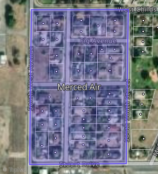
This property is located in Merced Air, Merced, CA 95341.
Seasonal Housing units 95341
17%of housing is for seasonal rent.
Daytime Population for 95341
-26%of people during work hours.
Boundary map of Merced Air.
Crime Index for 95341
122
The crime index in 95341 is 122, which is 1.2 times higher than national average.
Market Trends
Historical market data near 184 T St over selected time period.
Nearby Properties on T St
- 1833 T St, Merced, CA 95340 is a 0.17 acre property.
- 2346 T St, Merced, CA 95340 (Martinelli Trace) is a 936 square foot, 2 bedroom, 1 bathroom, 0.15 acre property. It was built in 1955 and has an estimate of $236,648 with a price per ft² of $253.
- 1260 T St, Merced, CA 95341 (The Nordman) is a 704 square foot, 2 bedroom, 2.25 bathroom, 0.34 acre property. It was built in 1940 and has an estimate of $329,775 with a price per ft² of $468.
- 705 T St, Merced, CA 95341 is a 1,172 square foot, 3 bedroom, 1 bathroom, 0.17 acre property. It was built in 1965 and has an estimate of $247,755 with a price per ft² of $211.
- 2105 T St, Merced, CA 95340 is a 1,536 square foot, 2 bedroom, 2 bathroom, 0.17 acre property. It was built in 1950 and has an estimate of $303,570 with a price per ft² of $197.
- 184 S T St, Merced, CA 95341 (Merced Air) is a 1,428 square foot, 3 bedroom, 2 bathroom, 0.17 acre property. It was built in 1942 and has an estimate of $289,078 with a price per ft² of $202.
- 170 S T St, Merced, CA 95341 (Merced Air) is a 1,344 square foot, 2 bedroom, 1 bathroom, 0.17 acre property. It was built in 1950 and has an estimate of $239,076 with a price per ft² of $178.
- 208 S T St, Merced, CA 95341 (Merced Air) is a 1,211 square foot, 3 bedroom, 2 bathroom, 0.2 acre property. It was built in 1967 and has an estimate of $269,085 with a price per ft² of $222.
- 158 S T St, Merced, CA 95341 (Merced Air) is a 793 square foot, 5 bedroom, 2 bathroom, 0.17 acre property. It was built in 1942 and has an estimate of $288,057 with a price per ft² of $363.
- 144 S T St, Merced, CA 95341 (Merced Air) is a 1,264 square foot, 3 bedroom, 2 bathroom, 0.17 acre property. It was built in 1995 and has an estimate of $312,475 with a price per ft² of $247.
- 195 S T St, Merced, CA 95341 (Merced Air) is a 1,056 square foot, 3 bedroom, 2 bathroom, 0.15 acre property. It was built in 2014 and has an estimate of $289,403 with a price per ft² of $274.
- 171 S T St, Merced, CA 95341 (Merced Air) is a 1,592 square foot, 4 bedroom, 2 bathroom, 0.15 acre property. It was built in 1942 and has an estimate of $279,364 with a price per ft² of $175.
- 207 S T St, Merced, CA 95341 (Merced Air) is a 1,038 square foot, 3 bedroom, 1 bathroom, 0.16 acre property. It was built in 1971 and has an estimate of $275,750 with a price per ft² of $266.
- 149 S T St, Merced, CA 95341 (Merced Air) is a 826 square foot, 3 bedroom, 1 bathroom, 0.15 acre property. It was built in 1942 and has an estimate of $209,623 with a price per ft² of $254.
- 115 T St, Merced, CA 95341 is a 1,150 square foot, 3 bedroom, 2 bathroom, 0.17 acre property. It was built in 1974 and has an estimate of $250,491 with a price per ft² of $218.
- 135 T St, Merced, CA 95341 is a 1,622 square foot, 4 bedroom, 2 bathroom, 0.17 acre property. It was built in 1960 and has an estimate of $259,641 with a price per ft² of $160.
- 810 T St, Merced, CA 95341 is a 0.52 acre property.
- 836 T St, Merced, CA 95341 is a 0.34 acre property.
- 805 T St, Merced, CA 95341 is a 952 square foot, 3 bedroom, 1 bathroom, 0.16 acre property. It was built in 1952 and has an estimate of $224,464 with a price per ft² of $236.
- 817 T St, Merced, CA 95341 is a 952 square foot, 2 bedroom, 1 bathroom, 0.17 acre property. It was built in 1952 and has an estimate of $236,576 with a price per ft² of $249.
- 831 T St, Merced, CA 95341 is a 1,342 square foot, 2 bedroom, 1 bathroom, 0.17 acre property. It was built in 1956 and has an estimate of $211,826 with a price per ft² of $158.
- 841 T St, Merced, CA 95341 is a 952 square foot, 2 bedroom, 1 bathroom, 0.17 acre property. It was built in 1952 and has an estimate of $227,891 with a price per ft² of $239.
- 2234 T St, Merced, CA 95340 is a 1,062 square foot, 2 bedroom, 1 bathroom, 0.17 acre property. It was built in 1951 and has an estimate of $263,649 with a price per ft² of $248.
- 2225 T St, Merced, CA 95340 (Viarengo Trace) is a 1,456 square foot, 3 bedroom, 2 bathroom, 0.14 acre property. It was built in 1988 and has an estimate of $307,555 with a price per ft² of $211.
- 2245 T St, Merced, CA 95340 (Viarengo Trace) is a 1,449 square foot, 3 bedroom, 1 bathroom, 0.17 acre property. It was built in 1950 and has an estimate of $302,545 with a price per ft² of $209.
- View more properties on T St