18700 Munro Ave
Stockton, CA 95215
- 3Beds
- 3Baths
- 2,611ft²Living Area
- 3.9acLot Size
- 1Pool
- 2Car
- 1989Year Built
- -DOM
- 5Permits
Permits
18700 Munro Ave has 5 permit records of total value of $83,870.
Current Ownership
Information about the current owner(s).
Taxes Billed
Taxes billed in 2023$4,146.02From latest Total Assessed Value1.08%Total Assessed Value$384,662=Land+
Assessed Value$112,439Additions
Assessed Value$272,223
In 2023, taxes billed for 18700 Munro Ave were $4,146.02, which is 1.08% from latest Total Assessed Value of $384,662.
Property History
18700 Munro Ave has undefined property events records (listings, deeds, permits, tax, foreclosure, loan).
Environment
Environmental factors around 18700 Munro Ave
Hazard Risks
Earthquake131Nat'l Avg100Particulates97Air Pollution84Carb Mono82Ozone82Lead41Tornado32Weather8Hail0Hurricane0Wind0
9 hazards (Carbon Monoxide, Earthquake Risk, Tornado Index, Air Pollution Index, Ozone Index, Weather Risk, Lead Index, Particulate Matter, National Average) are above the national average around 18700 Munro Ave.
Walkability Index
4 /20
Most Walkable
20-18
Very Walkable
17-15
Somewhat Walkable
14-10
Car Dependent
9-0
18700 Munro Ave has a walkability score of 4 out of 20, which means that it is in a car dependent area.
Temperature
Seasonal temperature sampled over multiple years
Winter
Average
Low
38°F
High
56°F
Summer
Average
Low
57°F
High
91°F
In the winter at 18700 Munro Ave, temperatures range from 38.1°F to 56.39°F with an average of 47.25°F. In the summer, the temperature ranges from 57.23°F to 90.93°F with and average of 74.08°F.
School Information
Public/private schools serving 18700 Munro Ave
Public Schools
Nearby public schools serving 18700 Munro Ave have ratings undefined, undefined, and undefined.
Neighborhood
This property is located in Munro Orchard, Stockton, CA 95215.
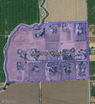
Boundary map of Munro Orchard.
Crime Index for 95215
86
The crime index in 95215 is 86, which is 0.9 times lower than national average.
Market Trends
Historical market data near 18700 Munro Ave over selected time period.
Nearby Properties on Munro Ave
- 18180 Munro Ave, Stockton, CA 95215 (Munro Orchard) is a 3,547 square foot, 3 bedroom, 5 bathroom, 7.46 acre property. It was built in 1991 and has an estimate of $1,151,824 with a price per ft² of $325.
- 18355 Munro Ave, Stockton, CA 95215 (Munro Orchard) is a 3,743 square foot, 4 bedroom, 3 bathroom, 5.76 acre property. It was built in 1991 and has an estimate of $1,132,558 with a price per ft² of $303.
- 18181 Munro Ave, Stockton, CA 95215 (Munro Orchard) is a 5,179 square foot, 5 bedroom, 6.25 bathroom, 6.66 acre property. It was built in 1991 and has an estimate of $1,490,324 with a price per ft² of $288.
- 18583 Munro Ave, Stockton, CA 95215 (Munro Orchard) is a 2,606 square foot, 3 bedroom, 3.25 bathroom, 4.82 acre property. It was built in 1990 and has an estimate of $1,003,456 with a price per ft² of $385.
- 18475 Munro Ave, Stockton, CA 95215 (Munro Orchard) is a 2,845 square foot, 3 bedroom, 3 bathroom, 4.96 acre property. It was built in 1991 and has an estimate of $923,786 with a price per ft² of $325.
- 18700 Munro Ave, Stockton, CA 95215 (Munro Orchard) is a 2,611 square foot, 3 bedroom, 4.25 bathroom, 3.89 acre property. It was built in 1989 and has an estimate of $902,776 with a price per ft² of $346.
- 18580 Munro Ave, Stockton, CA 95215 (Munro Orchard) is a 2,980 square foot, 4 bedroom, 3 bathroom, 4.89 acre property. It was built in 1990 and has an estimate of $953,981 with a price per ft² of $320.
- 18350 Munro Ave, Stockton, CA 95215 (Munro Orchard) is a 2,987 square foot, 3 bedroom, 4 bathroom, 5.99 acre property. It was built in 1991 and has an estimate of $863,685 with a price per ft² of $289.
- 18480 Munro Ave, Stockton, CA 95215 (Munro Orchard) is a 5,121 square foot, 3 bedroom, 4 bathroom, 5.41 acre property. It was built in 1990 and has an estimate of $1,195,318 with a price per ft² of $233.