188 Mayhews Rd
Fremont, CA 94536
- 3Beds
- 2Baths
- 2,267ft²Living Area
- 0.6acLot Size
- -Pool
- 3Car
- 1949Year Built
- -DOM
- 6Permits
Property Valuations
Latest estimates for 188 Mayhews Rd based on TopHap automated valuation model (AVM).
TopHap Estimate
$1,674,500
$738/ft²
Updated 3 months ago
188 Mayhews Rd is valued at $1,674,500 by TopHap AVM 3 months ago.
Permits
188 Mayhews Rd has 6 permit records.
Current Ownership
Information about the current owner(s).
Taxes Billed
Taxes billed in 2023$3,303.96From latest Total Assessed Value1.43%Total Assessed Value$231,054=Land+
Assessed Value$53,222Additions
Assessed Value$177,832
In 2023, taxes billed for 188 Mayhews Rd were $3,303.96, which is 1.43% from latest Total Assessed Value of $231,054.
Property History
188 Mayhews Rd has undefined property events records (listings, deeds, permits, tax, foreclosure, loan).
Environment
Environmental factors around 188 Mayhews Rd
Hazard Risks
Earthquake557Particulates103Nat'l Avg100Carb Mono100Air Pollution92Ozone86Lead39Tornado12Weather3Wind1Hail0Hurricane0
10 hazards (Carbon Monoxide, Earthquake Risk, Tornado Index, Air Pollution Index, Ozone Index, Wind Index, Weather Risk, Lead Index, Particulate Matter, National Average) are above the national average around 188 Mayhews Rd.
Walkability Index
9 /20
Most Walkable
20-18
Very Walkable
17-15
Somewhat Walkable
14-10
Car Dependent
9-0
188 Mayhews Rd has a walkability score of 9 out of 20, which means that it is in a car dependent area.
Noise Level
35 dB
Quiet Suburban Residential 0-49
Suburban Residential 50-54
Urban Residential 55-59
Noisy Urban Residential 60-64
Very Noisy Urban Residential 65+
Noise at 188 Mayhews Rd is around 35dBs, which is comparable to a Quiet Suburban Residential area.
Temperature
Seasonal temperature sampled over multiple years
Winter
Average
Low
42°F
High
59°F
Summer
Average
Low
55°F
High
78°F
In the winter at 188 Mayhews Rd, temperatures range from 41.54°F to 58.66°F with an average of 50.1°F. In the summer, the temperature ranges from 54.96°F to 78.03°F with and average of 66.5°F.
School Information
Public/private schools serving 188 Mayhews Rd
Public Schools
Nearby public schools serving 188 Mayhews Rd have ratings undefined, undefined, and undefined.
Neighborhood
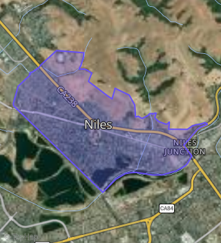
This property is located in Niles, Fremont, CA 94536.
Seasonal Housing units 94536
15%of housing is for seasonal rent.
Daytime Population for 94536
-18%of people during work hours.
Boundary map of Niles.
Crime Index for 94536
48
The crime index in 94536 is 48, which is 0.5 times lower than national average.
Market Trends
Historical market data near 188 Mayhews Rd over selected time period.
Nearby Properties on Mayhews Rd
- 156 Mayhews Rd, Fremont, CA 94536 (Niles) is a 1,345 square foot, 3 bedroom, 1 bathroom, 0.38 acre property. It was built in 1950 and has an estimate of $1,147,730 with a price per ft² of $853.
- 148 Mayhews Rd, Fremont, CA 94536 (Niles) is a 768 square foot, 2 bedroom, 1 bathroom, 0.16 acre property. It was built in 1960 and has an estimate of $904,175 with a price per ft² of $1,177.
- 188 Mayhews Rd, Fremont, CA 94536 (Niles) is a 2,267 square foot, 3 bedroom, 2 bathroom, 0.59 acre property. It was built in 1959 and has an estimate of $1,649,838 with a price per ft² of $728.
- 123 Mayhews Rd, Fremont, CA 94536 (Niles) is a 2,850 square foot and 8.25 acre property.
- 350 Mayhews Rd, Fremont, CA 94536 (Niles) is a 1,752 square foot, 3 bedroom, 2 bathroom, 1.16 acre property. It was built in 1950 and has an estimate of $1,094,545 with a price per ft² of $625.
- 350 Mayhews Rd, Fremont, CA 94536 is a 1,752 square foot, 3 bedroom, 2 bathroom, 33.79 acre property.
- 350 Mayhews Rd, Fremont, CA 94536 is a 1,752 square foot, 3 bedroom, 2 bathroom, 187.33 acre property.