202 High Dr
Spokane, WA 99203
- 5Beds
- 3Baths
- 3,994ft²Living Area
- 0.6acLot Size
- 1Pool
- 2Car
- 1965Year Built
- -DOM
- 11Permits
Property Valuations
Latest estimates for 202 High Dr based on TopHap automated valuation model (AVM).
TopHap Estimate
$766,500
$191/ft²
Updated 3 months ago
202 High Dr is valued at $766,500 by TopHap AVM 3 months ago.
Permits
202 High Dr has 11 permit records of total value of $170,000.
Current Ownership
Information about the current owner(s).
Taxes Billed
Taxes billed in 2022$10,603.04From latest Total Assessed Value1.17%Total Assessed Value$906,300=Land+
Assessed Value$165,000Additions
Assessed Value$741,300
In 2022, taxes billed for 202 High Dr were $10,603.04, which is 1.17% from latest Total Assessed Value of $906,300.
Property History
202 High Dr has undefined property events records (listings, deeds, permits, tax, foreclosure, loan).
Environment
Environmental factors around 202 High Dr
Hazard Risks
Carb Mono169Lead155Air Pollution112Ozone110Nat'l Avg100Particulates82Earthquake68Wind3Hail2Hurricane0Tornado0Weather0
9 hazards (Carbon Monoxide, Earthquake Risk, Hail Index, Air Pollution Index, Ozone Index, Wind Index, Lead Index, Particulate Matter, National Average) are above the national average around 202 High Dr.
Walkability Index
8 /20
Most Walkable
20-18
Very Walkable
17-15
Somewhat Walkable
14-10
Car Dependent
9-0
202 High Dr has a walkability score of 8 out of 20, which means that it is in a car dependent area.
Temperature
Seasonal temperature sampled over multiple years
Winter
Average
Low
23°F
High
36°F
Summer
Average
Low
51°F
High
81°F
In the winter at 202 High Dr, temperatures range from 23.3°F to 35.83°F with an average of 29.57°F. In the summer, the temperature ranges from 51.37°F to 80.71°F with and average of 66.04°F.
School Information
Public/private schools serving 202 High Dr
Public Schools
Nearby public schools serving 202 High Dr have ratings undefined, undefined, and undefined.
Neighborhood
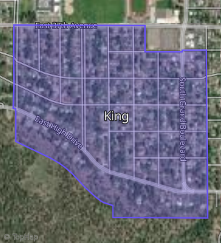
This property is located in King, Spokane, WA 99203.
Seasonal Housing units 99203
9%of housing is for seasonal rent.
Daytime Population for 99203
-12%of people during work hours.
Boundary map of King.
Crime Index for 99203
72
The crime index in 99203 is 72, which is 0.7 times lower than national average.
Market Trends
Historical market data near 202 High Dr over selected time period.
Nearby Properties on High Dr
- 135 E High Dr, Spokane, WA 99203 (King) is a 2,061 square foot, 4 bedroom, 3 bathroom, 0.35 acre property. It was built in 1980 and has an estimate of $815,174 with a price per ft² of $396.
- 105 E High Dr, Spokane, WA 99203 (King) is a 2,523 square foot, 2 bedroom, 2 bathroom, 0.2 acre property. It was built in 1950 and has an estimate of $725,171 with a price per ft² of $287.
- 47 E High Dr, Spokane, WA 99203 (King) is a 3,936 square foot, 4 bedroom, 4 bathroom, 0.55 acre property. It was built in 1956 and has an estimate of $1,278,151 with a price per ft² of $325.
- 23 E High Dr, Spokane, WA 99203 (King) is a 4,382 square foot, 6 bedroom, 4.25 bathroom, 0.29 acre property. It was built in 1948 and has an estimate of $1,000,882 with a price per ft² of $228.
- 15 E High Dr, Spokane, WA 99203 (King) is a 2,368 square foot, 3 bedroom, 4.25 bathroom, 0.21 acre property. It was built in 1948 and has an estimate of $703,415 with a price per ft² of $297.
- 9 E High Dr, Spokane, WA 99203 (King) is a 2,953 square foot, 4 bedroom, 3 bathroom, 0.28 acre property. It was built in 1947 and has an estimate of $721,050 with a price per ft² of $244.
- 324 W High Dr, Spokane, WA 99203 (Comstock Park) is a 3,641 square foot, 5 bedroom, 5.25 bathroom, 0.36 acre property. It was built in 2012 and has an estimate of $1,445,680 with a price per ft² of $397.
- 104 W High Dr, Spokane, WA 99203 (High Drive) is a 2,712 square foot, 3 bedroom, 4 bathroom, 0.47 acre property. It was built in 1975 and has an estimate of $1,174,641 with a price per ft² of $433.
- 100 W High Dr, Spokane, WA 99203 (High Drive) is a 0.44 acre property. It has an estimate of $203,900.
- 46 W High Dr, Spokane, WA 99203 (High Drive) is a 3,887 square foot, 5 bedroom, 5.25 bathroom, 0.41 acre property. It was built in 1975 and has an estimate of $1,787,340 with a price per ft² of $460.
- 30 W High Dr, Spokane, WA 99203 (High Drive) is a 2,392 square foot, 3 bedroom, 3.25 bathroom, 0.39 acre property. It was built in 1977 and has an estimate of $1,110,878 with a price per ft² of $464.
- 10 W High Dr, Spokane, WA 99203 (High Drive) is a 4,211 square foot, 5 bedroom, 5.25 bathroom, 0.7 acre property. It was built in 1968 and has an estimate of $1,308,113 with a price per ft² of $311.
- 24 W High Dr, Spokane, WA 99203 (High Drive) is a 0.09 acre property.
- 122 W High Dr, Spokane, WA 99203 (High Drive) is a 2,690 square foot, 5 bedroom, 4 bathroom, 0.47 acre property. It was built in 1995 and has an estimate of $1,328,526 with a price per ft² of $494.
- 1 W High Dr, Spokane, WA 99203 is a 2,746 square foot, 4 bedroom, 4.5 bathroom, 0.74 acre property. It was built in 1975 and has an estimate of $1,185,043 with a price per ft² of $432.
- 2821 S High Dr, Spokane, WA 99203 is a 1,921 square foot, 5 bedroom, 3 bathroom, 0.28 acre property. It was built in 1993 and has an estimate of $851,700 with a price per ft² of $443.
- View more properties on High Dr