2031 Mt Whitney Ave
Corcoran, CA 93212
- 3Beds
- 2Baths
- 1,557ft²Living Area
- 6,036ft²Lot Size
- -Pool
- 2Car
- 2007Year Built
- -DOM
- -Permit
Property Valuations
Latest estimates for 2031 Mt Whitney Ave based on TopHap automated valuation model (AVM).
TopHap Estimate
$297,250
$190/ft²
+$157K above Sold Price
Updated 3 months ago
Last Sold Price
$140,000
$90/ft²
10 years ago
2031 Mt Whitney Ave is valued at $297,250 by TopHap AVM 3 months ago.
2031 Mt Whitney Ave was last sold in 2014 for $140,000.
Current Ownership
Information about the current owner(s).
Taxes Billed
Taxes billed in 2023$1,677.62From latest Total Assessed Value1.02%Total Assessed Value$164,958=Land+
Assessed Value$23,566Additions
Assessed Value$141,392
In 2023, taxes billed for 2031 Mt Whitney Ave were $1,677.62, which is 1.02% from latest Total Assessed Value of $164,958.
Property History
2031 Mt Whitney Ave has undefined property events records (listings, deeds, permits, tax, foreclosure, loan).
Environment
Environmental factors around 2031 Mt Whitney Ave
Hazard Risks
Nat'l Avg100Earthquake94Particulates89Ozone69Air Pollution69Carb Mono64Lead41Tornado12Weather4Hail0Hurricane0Wind0
9 hazards (Carbon Monoxide, Earthquake Risk, Tornado Index, Air Pollution Index, Ozone Index, Weather Risk, Lead Index, Particulate Matter, National Average) are above the national average around 2031 Mt Whitney Ave.
Walkability Index
6 /20
Most Walkable
20-18
Very Walkable
17-15
Somewhat Walkable
14-10
Car Dependent
9-0
2031 Mt Whitney Ave has a walkability score of 6 out of 20, which means that it is in a car dependent area.
Temperature
Seasonal temperature sampled over multiple years
Winter
Average
Low
37°F
High
57°F
Summer
Average
Low
62°F
High
96°F
In the winter at 2031 Mt Whitney Ave, temperatures range from 36.78°F to 57.28°F with an average of 47.03°F. In the summer, the temperature ranges from 62°F to 96.14°F with and average of 79.07°F.
School Information
Public/private schools serving 2031 Mt Whitney Ave
Public Schools
Nearby public schools serving 2031 Mt Whitney Ave have ratings undefined, undefined, undefined, undefined, and undefined.
Neighborhood
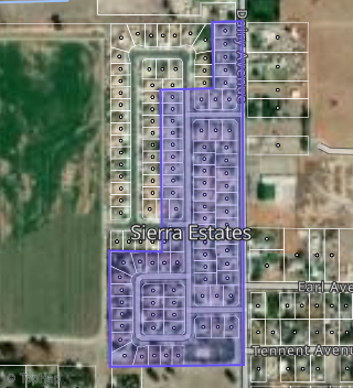
This property is located in Sierra Estates, Corcoran, CA 93212.
Seasonal Housing units 93212
2%of housing is for seasonal rent.
Daytime Population for 93212
-17%of people during work hours.
Boundary map of Sierra Estates.
Crime Index for 93212
87
The crime index in 93212 is 87, which is 0.9 times lower than national average.
Market Trends
Historical market data near 2031 Mt Whitney Ave over selected time period.
Nearby Properties on Mt Whitney Ave
- 2019 Mt Whitney Ave, Corcoran, CA 93212 (Sierra Estates) is a 2,562 square foot, 4 bedroom, 3 bathroom, 0.14 acre property. It was built in 2007 and has an estimate of $336,116 with a price per ft² of $131.
- 2037 Mt Whitney Ave, Corcoran, CA 93212 (Sierra Estates) is a 1,694 square foot, 3 bedroom, 2 bathroom, 0.14 acre property. It was built in 2007 and has an estimate of $293,739 with a price per ft² of $173.
- 2031 Mt Whitney Ave, Corcoran, CA 93212 (Sierra Estates) is a 1,557 square foot, 3 bedroom, 2 bathroom, 0.14 acre property. It was built in 2007 and has an estimate of $290,267 with a price per ft² of $186.
- 2025 Mt Whitney Ave, Corcoran, CA 93212 (Sierra Estates) is a 1,875 square foot, 4 bedroom, 2 bathroom, 0.14 acre property. It was built in 2007 and has an estimate of $294,688 with a price per ft² of $157.