22510 Fireside Dr
Twain Harte, CA 95383
- 4Beds
- 1Bath
- 1,156ft²Living Area
- 6,098ft²Lot Size
- -Pool
- -Car
- 1954Year Built
- -DOM
- -Permit
Property Valuations
Latest estimates for 22510 Fireside Dr based on TopHap automated valuation model (AVM).
TopHap Estimate
$483,800
$418/ft²
+$169K above Sold Price
Updated 3 months ago
Last Sold Price
$315,000
$272/ft²
16 years ago
22510 Fireside Dr is valued at $483,800 by TopHap AVM 3 months ago.
22510 Fireside Dr was last sold in 2008 for $315,000.
Current Ownership
Information about the current owner(s).
Taxes Billed
Taxes billed in 2023$4,141.52From latest Total Assessed Value1.17%Total Assessed Value$354,884=Land+
Assessed Value$127,065Additions
Assessed Value$227,819
In 2023, taxes billed for 22510 Fireside Dr were $4,141.52, which is 1.17% from latest Total Assessed Value of $354,884.
Property History
22510 Fireside Dr has undefined property events records (listings, deeds, permits, tax, foreclosure, loan).
Environment
Environmental factors around 22510 Fireside Dr
Hazard Risks
Nat'l Avg100Particulates94Earthquake93Carb Mono86Ozone83Air Pollution83Lead39Hail3Hurricane0Tornado0Weather0Wind0
8 hazards (Carbon Monoxide, Earthquake Risk, Hail Index, Air Pollution Index, Ozone Index, Lead Index, Particulate Matter, National Average) are above the national average around 22510 Fireside Dr.
Walkability Index
8 /20
Most Walkable
20-18
Very Walkable
17-15
Somewhat Walkable
14-10
Car Dependent
9-0
22510 Fireside Dr has a walkability score of 8 out of 20, which means that it is in a car dependent area.
Temperature
Seasonal temperature sampled over multiple years
Winter
Average
Low
28°F
High
48°F
Summer
Average
Low
51°F
High
80°F
In the winter at 22510 Fireside Dr, temperatures range from 27.81°F to 48.22°F with an average of 38.02°F. In the summer, the temperature ranges from 51.09°F to 80.06°F with and average of 65.58°F.
School Information
Public/private schools serving 22510 Fireside Dr
Public Schools
Nearby public schools serving 22510 Fireside Dr have ratings undefined.
Neighborhood
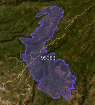
This property is located in Twain Harte.
Seasonal Housing units 95383
93%of housing is for seasonal rent.
Daytime Population for 95383
-19%of people during work hours.
Boundary map of Twain Harte.
Crime Index for 95383
130
The crime index in 95383 is 130, which is 1.3 times higher than national average.
Market Trends
Historical market data near 22510 Fireside Dr over selected time period.
Nearby Properties on Fireside Dr
- 22486 Fireside Dr, Twain Harte, CA 95383 is a 1,548 square foot, 3 bedroom, 2 bathroom, 0.36 acre property. It was built in 1936 and has an estimate of $519,437 with a price per ft² of $336.
- 22494 Fireside Dr, Twain Harte, CA 95383 is a 1,736 square foot, 3 bedroom, 2 bathroom, 0.23 acre property. It was built in 1935 and has an estimate of $651,787 with a price per ft² of $375.
- 22502 Fireside Dr, Twain Harte, CA 95383 is a 1,828 square foot, 3 bedroom, 2 bathroom, 0.25 acre property. It was built in 1997 and has an estimate of $574,867 with a price per ft² of $314.
- 22510 Fireside Dr, Twain Harte, CA 95383 is a 1,156 square foot, 4 bedroom, 1 bathroom, 0.14 acre property. It was built in 1954 and has an estimate of $361,926 with a price per ft² of $313.
- 22487 Fireside Dr, Twain Harte, CA 95383 is a 911 square foot, 3 bedroom, 1 bathroom, 0.15 acre property. It was built in 1954 and has an estimate of $368,196 with a price per ft² of $404.
- 22481 Fireside Dr, Twain Harte, CA 95383 is a 2,520 square foot, 3 bedroom, 3 bathroom, 0.16 acre property. It was built in 1954 and has an estimate of $741,430 with a price per ft² of $294.
- 22511 Fireside Dr, Twain Harte, CA 95383 is a 1,282 square foot, 4 bedroom, 3 bathroom, 0.45 acre property. It was built in 1945 and has an estimate of $473,037 with a price per ft² of $369.
- 22499 Fireside Dr, Twain Harte, CA 95383 is a 2,316 square foot, 3 bedroom, 3.25 bathroom, 0.18 acre property. It was built in 1994 and has an estimate of $625,907 with a price per ft² of $270.
- 22493 Fireside Dr, Twain Harte, CA 95383 is a 1,652 square foot, 4 bedroom, 1 bathroom, 0.18 acre property. It was built in 1975 and has an estimate of $405,161 with a price per ft² of $245.
- 22505 Fireside Dr, Twain Harte, CA 95383 is a 928 square foot, 2 bedroom, 1 bathroom, 0.12 acre property. It was built in 1949 and has an estimate of $345,699 with a price per ft² of $373.
- 22511 Fireside Dr, Twain Harte, CA 95383 is a 1.17 acre property.