272 De Soto Dr
Fairfield, CA 94533
- 4Beds
- 2Baths
- 1,248ft²Living Area
- 6,969ft²Lot Size
- -Pool
- 2Car
- 1971Year Built
- -DOM
- 2Permits
Property Valuations
Latest estimates for 272 De Soto Dr based on TopHap automated valuation model (AVM).
TopHap Estimate
$485,500
$389/ft²
+$343K above Sold Price
Updated 3 months ago
Last Sold Price
$143,000
$115/ft²
11 years ago
272 De Soto Dr is valued at $485,500 by TopHap AVM 3 months ago.
272 De Soto Dr was last sold in 2012 for $143,000.
Permits
272 De Soto Dr has 2 permit records.
Current Ownership
Information about the current owner(s).
Taxes Billed
Taxes billed in 2022$3,751.00From latest Total Assessed Value1.12%Total Assessed Value$336,324=Land+
Assessed Value$105,972Additions
Assessed Value$230,352
In 2022, taxes billed for 272 De Soto Dr were $3,751, which is 1.12% from latest Total Assessed Value of $336,324.
Property History
272 De Soto Dr has undefined property events records (listings, deeds, permits, tax, foreclosure, loan).
Environment
Environmental factors around 272 De Soto Dr
Hazard Risks
Earthquake395Nat'l Avg100Particulates93Carb Mono87Air Pollution87Ozone83Lead42Hail2Hurricane0Tornado0Weather0Wind0
8 hazards (Carbon Monoxide, Earthquake Risk, Hail Index, Air Pollution Index, Ozone Index, Lead Index, Particulate Matter, National Average) are above the national average around 272 De Soto Dr.
Walkability Index
11 /20
Most Walkable
20-18
Very Walkable
17-15
Somewhat Walkable
14-10
Car Dependent
9-0
272 De Soto Dr has a walkability score of 11 out of 20, which means that it is in a somewhat walkable area.
Noise Level
40 dB
Quiet Suburban Residential 0-49
Suburban Residential 50-54
Urban Residential 55-59
Noisy Urban Residential 60-64
Very Noisy Urban Residential 65+
Noise at 272 De Soto Dr is around 40dBs, which is comparable to a Quiet Suburban Residential area.
Temperature
Seasonal temperature sampled over multiple years
Winter
Average
Low
39°F
High
57°F
Summer
Average
Low
56°F
High
86°F
In the winter at 272 De Soto Dr, temperatures range from 38.68°F to 56.92°F with an average of 47.8°F. In the summer, the temperature ranges from 55.54°F to 85.68°F with and average of 70.61°F.
School Information
Public/private schools serving 272 De Soto Dr
Public Schools
Nearby public schools serving 272 De Soto Dr have ratings undefined, undefined, undefined, and undefined.
Neighborhood
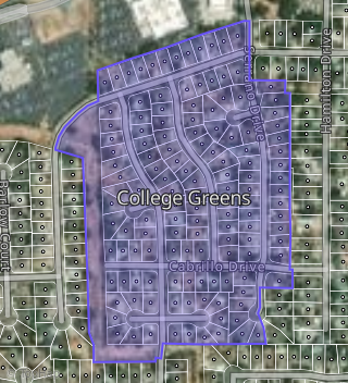
This property is located in College Greens, Fairfield, CA 94533.
Seasonal Housing units 94533
16%of housing is for seasonal rent.
Daytime Population for 94533
-7%of people during work hours.
Boundary map of College Greens.
Crime Index for 94533
103
The crime index in 94533 is 103, which is 1.0 times higher than national average.
Market Trends
Historical market data near 272 De Soto Dr over selected time period.
Nearby Properties on De Soto Dr
- 272 De Soto Dr, Fairfield, CA 94533 (College Greens) is a 1,248 square foot, 4 bedroom, 2 bathroom, 0.16 acre property. It was built in 1971 and has an estimate of $480,749 with a price per ft² of $385.
- 237 De Soto Dr, Fairfield, CA 94533 (College Greens) is a 1,248 square foot, 4 bedroom, 2 bathroom, 0.14 acre property. It was built in 1970 and has an estimate of $467,301 with a price per ft² of $374.
- 218 De Soto Dr, Fairfield, CA 94533 (College Greens) is a 1,248 square foot, 4 bedroom, 2 bathroom, 0.14 acre property. It was built in 1971 and has an estimate of $476,724 with a price per ft² of $382.
- 266 De Soto Dr, Fairfield, CA 94533 (College Greens) is a 2,039 square foot, 3 bedroom, 2 bathroom, 0.14 acre property. It was built in 1970 and has an estimate of $591,166 with a price per ft² of $290.
- 231 De Soto Dr, Fairfield, CA 94533 (College Greens) is a 1,248 square foot, 4 bedroom, 2 bathroom, 0.17 acre property. It was built in 1971 and has an estimate of $490,614 with a price per ft² of $393.
- 243 De Soto Dr, Fairfield, CA 94533 (College Greens) is a 1,248 square foot, 4 bedroom, 2 bathroom, 0.16 acre property. It was built in 1971 and has an estimate of $481,923 with a price per ft² of $386.
- 225 De Soto Dr, Fairfield, CA 94533 (College Greens) is a 1,248 square foot, 4 bedroom, 2 bathroom, 0.16 acre property. It was built in 1972 and has an estimate of $483,585 with a price per ft² of $387.
- 236 De Soto Dr, Fairfield, CA 94533 (College Greens) is a 1,248 square foot, 4 bedroom, 2 bathroom, 0.18 acre property. It was built in 1970 and has an estimate of $480,660 with a price per ft² of $385.
- 230 De Soto Dr, Fairfield, CA 94533 (College Greens) is a 1,248 square foot, 4 bedroom, 2 bathroom, 0.15 acre property. It was built in 1970 and has an estimate of $476,928 with a price per ft² of $382.
- 242 De Soto Dr, Fairfield, CA 94533 (College Greens) is a 1,248 square foot, 4 bedroom, 2 bathroom, 0.21 acre property. It was built in 1971 and has an estimate of $477,001 with a price per ft² of $382.
- 249 De Soto Dr, Fairfield, CA 94533 (College Greens) is a 1,248 square foot, 4 bedroom, 2 bathroom, 0.15 acre property. It was built in 1971 and has an estimate of $488,604 with a price per ft² of $392.
- 255 De Soto Dr, Fairfield, CA 94533 (College Greens) is a 1,248 square foot, 4 bedroom, 2 bathroom, 0.15 acre property. It was built in 1971 and has an estimate of $491,403 with a price per ft² of $394.
- 248 De Soto Dr, Fairfield, CA 94533 (College Greens) is a 1,109 square foot, 3 bedroom, 2 bathroom, 0.14 acre property. It was built in 1970 and has an estimate of $467,309 with a price per ft² of $421.
- 219 De Soto Dr, Fairfield, CA 94533 (College Greens) is a 1,109 square foot, 3 bedroom, 2 bathroom, 0.13 acre property. It was built in 1970 and has an estimate of $496,998 with a price per ft² of $448.
- 261 De Soto Dr, Fairfield, CA 94533 (College Greens) is a 1,248 square foot, 4 bedroom, 2 bathroom, 0.16 acre property. It was built in 1971 and has an estimate of $493,602 with a price per ft² of $396.
- 254 De Soto Dr, Fairfield, CA 94533 (College Greens) is a 1,609 square foot, 4 bedroom, 2 bathroom, 0.16 acre property. It was built in 1971 and has an estimate of $557,844 with a price per ft² of $347.
- 260 De Soto Dr, Fairfield, CA 94533 (College Greens) is a 1,536 square foot, 4 bedroom, 2 bathroom, 0.14 acre property. It was built in 1971 and has an estimate of $544,259 with a price per ft² of $354.
- 267 De Soto Dr, Fairfield, CA 94533 (College Greens) is a 1,109 square foot, 3 bedroom, 2 bathroom, 0.14 acre property. It was built in 1970 and has an estimate of $468,036 with a price per ft² of $422.
- 224 De Soto Dr, Fairfield, CA 94533 (College Greens) is a 1,248 square foot, 4 bedroom, 2 bathroom, 0.14 acre property. It was built in 1971 and has an estimate of $464,784 with a price per ft² of $372.
- 206 De Soto Dr, Fairfield, CA 94533 (College Greens) is a 1,248 square foot, 4 bedroom, 2 bathroom, 0.13 acre property. It was built in 1971 and has an estimate of $443,634 with a price per ft² of $355.
- 212 De Soto Dr, Fairfield, CA 94533 (College Greens) is a 1,248 square foot, 4 bedroom, 2 bathroom, 0.13 acre property. It was built in 1971 and has an estimate of $453,948 with a price per ft² of $364.
- 213 De Soto Dr, Fairfield, CA 94533 (College Greens) is a 1,248 square foot, 4 bedroom, 2 bathroom, 0.15 acre property. It was built in 1971 and has an estimate of $457,380 with a price per ft² of $366.
- 207 De Soto Dr, Fairfield, CA 94533 (College Greens) is a 1,248 square foot, 4 bedroom, 2 bathroom, 0.14 acre property. It was built in 1970 and has an estimate of $465,998 with a price per ft² of $373.
- 200 De Soto Dr, Fairfield, CA 94533 (College Greens) is a 1,609 square foot, 4 bedroom, 2 bathroom, 0.16 acre property. It was built in 1971 and has an estimate of $512,339 with a price per ft² of $318.
- 273 De Soto Dr, Fairfield, CA 94533 (College Greens) is a 1,704 square foot, 4 bedroom, 2 bathroom, 0.17 acre property. It was built in 1972 and has an estimate of $521,775 with a price per ft² of $306.