28 Mcdonnel Rd
Alameda, CA 94502
- 4Beds
- 3Baths
- 1,740ft²Living Area
- 2,560ft²Lot Size
- -Pool
- 2Car
- 1996Year Built
- -DOM
- 5Permits
Permits
28 Mcdonnel Rd has 5 permit records of total value of $154,742.
Current Ownership
Information about the current owner(s).
Taxes Billed
Taxes billed in 2023$20,912.88From latest Total Assessed Value1.31%Total Assessed Value$1,591,200=Land+
Assessed Value$477,360Additions
Assessed Value$1,113,840
In 2023, taxes billed for 28 Mcdonnel Rd were $20,912.88, which is 1.31% from latest Total Assessed Value of $1,591,200.
Property History
28 Mcdonnel Rd has undefined property events records (listings, deeds, permits, tax, foreclosure, loan).
Environment
Environmental factors around 28 Mcdonnel Rd
Hazard Risks
Earthquake379Carb Mono101Nat'l Avg100Particulates96Ozone90Air Pollution90Lead37Tornado13Weather3Hail0Hurricane0Wind0
9 hazards (Carbon Monoxide, Earthquake Risk, Tornado Index, Air Pollution Index, Ozone Index, Weather Risk, Lead Index, Particulate Matter, National Average) are above the national average around 28 Mcdonnel Rd.
Walkability Index
16 /20
Most Walkable
20-18
Very Walkable
17-15
Somewhat Walkable
14-10
Car Dependent
9-0
28 Mcdonnel Rd has a walkability score of 16 out of 20, which means that it is in a very walkable area.
Noise Level
59 dB
Quiet Suburban Residential 0-49
Suburban Residential 50-54
Urban Residential 55-59
Noisy Urban Residential 60-64
Very Noisy Urban Residential 65+
Noise at 28 Mcdonnel Rd is around 59dBs, which is comparable to a Urban Residential area.
Temperature
Seasonal temperature sampled over multiple years
Winter
Average
Low
44°F
High
58°F
Summer
Average
Low
55°F
High
71°F
In the winter at 28 Mcdonnel Rd, temperatures range from 44.27°F to 58.45°F with an average of 51.36°F. In the summer, the temperature ranges from 54.9°F to 71.42°F with and average of 63.16°F.
School Information
Public/private schools serving 28 Mcdonnel Rd
Public Schools
Nearby public schools serving 28 Mcdonnel Rd have ratings undefined, undefined, and undefined.
Neighborhood
This property is located in Bay Farm Island, Alameda, CA 94502.
Seasonal Housing units 94502
20%of housing is for seasonal rent.
Daytime Population for 94502
+30%of people during work hours.
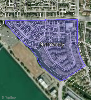
Boundary map of Bay Farm Island.
Crime Index for 94502
34
The crime index in 94502 is 34, which is 0.3 times lower than national average.
Market Trends
Historical market data near 28 Mcdonnel Rd over selected time period.
Nearby Properties on Mcdonnel Rd
- 42 Mcdonnel Rd, Alameda, CA 94502 (Normandy) is a 2,040 square foot, 3 bedroom, 3.25 bathroom, 0.09 acre property. It was built in 1996 and has an estimate of $1,549,469 with a price per ft² of $760.
- 218 Mcdonnel Rd, Alameda, CA 94502 (Normandy) is a 1,740 square foot, 4 bedroom, 2.5 bathroom, 0.1 acre property. It was built in 1997 and has an estimate of $1,363,103 with a price per ft² of $708.
- 28 Mcdonnel Rd, Alameda, CA 94502 (Normandy) is a 1,879 square foot, 4 bedroom, 3.25 bathroom, 0.06 acre property. It was built in 1996 and has an estimate of $1,383,695 with a price per ft² of $736.
- 318 Mcdonnel Rd, Alameda, CA 94502 (Normandy) is a 1,439 square foot, 2 bedroom, 2.5 bathroom, 0.09 acre property. It was built in 1994 and has an estimate of $1,302,352 with a price per ft² of $905.
- 423 Mcdonnel Rd, Alameda, CA 94502 (Normandy) is a 1,694 square foot, 3 bedroom, 3.25 bathroom, 0.06 acre property. It was built in 1992 and has an estimate of $1,284,992 with a price per ft² of $759.
- 112 Mcdonnel Rd, Alameda, CA 94502 (Normandy) is a 1,628 square foot, 3 bedroom, 3.25 bathroom, 0.09 acre property. It was built in 1996 and has an estimate of $1,263,422 with a price per ft² of $849.
- 451 Mcdonnel Rd, Alameda, CA 94502 (Normandy) is a 1,049 square foot, 2 bedroom, 2 bathroom, 0.06 acre property. It was built in 1992 and has an estimate of $905,347 with a price per ft² of $863.
- 225 Mcdonnel Rd, Alameda, CA 94502 (Normandy) is a 1,740 square foot, 4 bedroom, 3.25 bathroom, 0.09 acre property. It was built in 1997 and has an estimate of $1,394,639 with a price per ft² of $802.
- 445 Mcdonnel Rd, Alameda, CA 94502 (Normandy) is a 1,782 square foot, 3 bedroom, 3.25 bathroom, 0.06 acre property. It was built in 1993 and has an estimate of $1,319,227 with a price per ft² of $740.
- 426 Mcdonnel Rd, Alameda, CA 94502 (Normandy) is a 1,519 square foot, 2 bedroom, 3.25 bathroom, 0.06 acre property. It was built in 1993 and has an estimate of $1,152,376 with a price per ft² of $759.
- 332 Mcdonnel Rd, Alameda, CA 94502 (Normandy) is a 1,772 square foot, 3 bedroom, 3.25 bathroom, 0.07 acre property. It was built in 1993 and has an estimate of $1,335,964 with a price per ft² of $754.
- 8 Mcdonnel Rd, Alameda, CA 94502 (Normandy) is a 1,489 square foot, 3 bedroom, 3.25 bathroom, 0.06 acre property. It was built in 1996 and has an estimate of $1,161,264 with a price per ft² of $780.
- 35 Mcdonnel Rd, Alameda, CA 94502 (Normandy) is a 2,399 square foot, 4 bedroom, 4.25 bathroom, 0.1 acre property. It was built in 1996 and has an estimate of $1,596,458 with a price per ft² of $665.
- 212 Mcdonnel Rd, Alameda, CA 94502 (Normandy) is a 1,458 square foot, 3 bedroom, 3.25 bathroom, 0.1 acre property. It was built in 1997 and has an estimate of $1,326,337 with a price per ft² of $910.
- 126 Mcdonnel Rd, Alameda, CA 94502 (Normandy) is a 1,740 square foot, 4 bedroom, 3.25 bathroom, 0.09 acre property. It was built in 1996 and has an estimate of $1,365,784 with a price per ft² of $785.
- 132 Mcdonnel Rd, Alameda, CA 94502 (Normandy) is a 1,616 square foot, 3 bedroom, 2.5 bathroom, 0.09 acre property. It was built in 1996 and has an estimate of $1,264,449 with a price per ft² of $782.
- 433 Mcdonnel Rd, Alameda, CA 94502 (Normandy) is a 1,519 square foot, 2 bedroom, 3.25 bathroom, 0.06 acre property. It was built in 1992 and has an estimate of $1,155,216 with a price per ft² of $761.
- 100 Mcdonnel Rd, Alameda, CA 94502 (Normandy) is a 1,458 square foot, 3 bedroom, 3.25 bathroom, 0.11 acre property. It was built in 1997 and has an estimate of $1,330,814 with a price per ft² of $913.
- 412 Mcdonnel Rd, Alameda, CA 94502 (Normandy) is a 1,049 square foot, 2 bedroom, 2 bathroom, 0.06 acre property. It was built in 1992 and has an estimate of $880,534 with a price per ft² of $839.
- 312 Mcdonnel Rd, Alameda, CA 94502 (Normandy) is a 1,019 square foot, 2 bedroom, 2 bathroom, 0.09 acre property. It was built in 1994 and has an estimate of $1,036,307 with a price per ft² of $1,017.
- 248 Mcdonnel Rd, Alameda, CA 94502 (Normandy) is a 1,616 square foot, 3 bedroom, 2.5 bathroom, 0.09 acre property. It was built in 1997 and has an estimate of $1,367,483 with a price per ft² of $846.
- 472 Mcdonnel Rd, Alameda, CA 94502 (Normandy) is a 1,782 square foot, 3 bedroom, 3.25 bathroom, 0.06 acre property. It was built in 1992 and has an estimate of $1,280,837 with a price per ft² of $719.
- 238 Mcdonnel Rd, Alameda, CA 94502 (Normandy) is a 1,458 square foot, 3 bedroom, 2.5 bathroom, 0.09 acre property. It was built in 1997 and has an estimate of $1,277,843 with a price per ft² of $876.
- 5 Mcdonnel Rd, Alameda, CA 94502 (Normandy) is a 1,740 square foot, 4 bedroom, 3.25 bathroom, 0.1 acre property. It was built in 1996 and has an estimate of $1,312,130 with a price per ft² of $754.
- 306 Mcdonnel Rd, Alameda, CA 94502 (Normandy) is a 2,086 square foot, 3 bedroom, 2.5 bathroom, 0.09 acre property. It was built in 1994 and has an estimate of $1,572,598 with a price per ft² of $881.
- View more properties on Mcdonnel Rd