3085 Angus Ct
Peyton, CO 80831
- 8Beds
- 4Baths
- 2,368ft²Living Area
- 6.2acLot Size
- -Pool
- 2Car
- 2004Year Built
- -DOM
- 5Permits
Property Valuations
Latest estimates for 3085 Angus Ct based on TopHap automated valuation model (AVM).
TopHap Estimate
$682,073
$288/ft²
+$43K above Sold Price
Updated 3 months ago
Last Sold Price
$639,000
$270/ft²
2 years ago
3085 Angus Ct is valued at $682,073 by TopHap AVM 3 months ago.
3085 Angus Ct was last sold in 2021 for $639,000.
Permits
3085 Angus Ct has 5 permit records of total value of $13,325.
Current Ownership
Information about the current owner(s).
Taxes Billed
Taxes billed in 2022$2,261.28From latest Total Assessed Value6.94%Total Assessed Value$32,570=Land+
Assessed Value$5,130Additions
Assessed Value$27,440
In 2022, taxes billed for 3085 Angus Ct were $2,261.28, which is 6.94% from latest Total Assessed Value of $32,570.
Property History
3085 Angus Ct has undefined property events records (listings, deeds, permits, tax, foreclosure, loan).
Environment
Environmental factors around 3085 Angus Ct
Hazard Risks
Carb Mono119Tornado114Nat'l Avg100Particulates95Ozone94Air Pollution93Weather47Lead40Earthquake39Hail23Hurricane0Wind0
10 hazards (Carbon Monoxide, Earthquake Risk, Hail Index, Tornado Index, Air Pollution Index, Ozone Index, Weather Risk, Lead Index, Particulate Matter, National Average) are above the national average around 3085 Angus Ct.
Walkability Index
5 /20
Most Walkable
20-18
Very Walkable
17-15
Somewhat Walkable
14-10
Car Dependent
9-0
3085 Angus Ct has a walkability score of 5 out of 20, which means that it is in a car dependent area.
Temperature
Seasonal temperature sampled over multiple years
Winter
Average
Low
16°F
High
43°F
Summer
Average
Low
51°F
High
80°F
In the winter at 3085 Angus Ct, temperatures range from 15.62°F to 43.34°F with an average of 29.48°F. In the summer, the temperature ranges from 50.62°F to 80.36°F with and average of 65.49°F.
School Information
Public/private schools serving 3085 Angus Ct
Public Schools
Nearby public schools serving 3085 Angus Ct have ratings undefined, undefined, and undefined.
Neighborhood
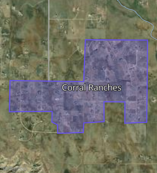
This property is located in Corral Ranches, Peyton, CO 80831.
Seasonal Housing units 80831
16%of housing is for seasonal rent.
Daytime Population for 80831
-19%of people during work hours.
Boundary map of Corral Ranches.
Crime Index for 80831
32
The crime index in 80831 is 32, which is 0.3 times lower than national average.
Market Trends
Historical market data near 3085 Angus Ct over selected time period.
Nearby Properties on Angus Ct
- 3085 Angus Ct, Peyton, CO 80831 (Corral Ranches) is a 2,368 square foot, 8 bedroom, 4 bathroom, 6.18 acre property. It was built in 2004 and has an estimate of $768,727 with a price per ft² of $325.
- 3090 Angus Ct, Peyton, CO 80831 (Corral Ranches) is a 2,052 square foot, 4 bedroom, 2 bathroom, 6.24 acre property. It was built in 2004 and has an estimate of $627,917 with a price per ft² of $306.
- 3170 Angus Ct, Peyton, CO 80831 (Corral Ranches) is a 1,520 square foot, 4 bedroom, 3 bathroom, 5.2 acre property. It was built in 2007 and has an estimate of $787,899 with a price per ft² of $518.
- 3165 Angus Ct, Peyton, CO 80831 (Corral Ranches) is a 2,296 square foot, 3 bedroom, 2 bathroom, 5.18 acre property. It was built in 2004 and has an estimate of $587,599 with a price per ft² of $256.
- 3245 Angus Ct, Peyton, CO 80831 (Corral Ranches) is a 2,055 square foot, 3 bedroom, 2 bathroom, 5.19 acre property. It was built in 2004 and has an estimate of $621,441 with a price per ft² of $302.
- 3250 Angus Ct, Peyton, CO 80831 (Corral Ranches) is a 2,090 square foot, 5 bedroom, 2 bathroom, 5.2 acre property. It was built in 2007 and has an estimate of $713,800 with a price per ft² of $342.
- 3010 Angus Ct, Peyton, CO 80831 (Corral Ranches) is a 1,408 square foot, 3 bedroom, 2 bathroom, 5.43 acre property. It was built in 2000 and has an estimate of $711,686 with a price per ft² of $505.