452 Mckenzie Ct
Watsonville, CA 95076
- 3Beds
- 1Bath
- 1,105ft²Living Area
- 6,490ft²Lot Size
- -Pool
- 1Car
- 1951Year Built
- -DOM
- -Permit
Property Valuations
Latest estimates for 452 Mckenzie Ct based on TopHap automated valuation model (AVM).
TopHap Estimate
$544,250
$492/ft²
+$234K above Sold Price
Updated 3 months ago
Last Sold Price
$310,000
$281/ft²
10 years ago
452 Mckenzie Ct is valued at $544,250 by TopHap AVM 3 months ago.
452 Mckenzie Ct was last sold in 2013 for $310,000.
Current Ownership
Information about the current owner(s).
Taxes Billed
Taxes billed in 2023$4,550.64From latest Total Assessed Value1.24%Total Assessed Value$366,919=Land+
Assessed Value$218,968Additions
Assessed Value$147,951
In 2023, taxes billed for 452 Mckenzie Ct were $4,550.64, which is 1.24% from latest Total Assessed Value of $366,919.
Property History
452 Mckenzie Ct has undefined property events records (listings, deeds, permits, tax, foreclosure, loan).
Environment
Environmental factors around 452 Mckenzie Ct
Hazard Risks
Earthquake510Particulates102Nat'l Avg100Air Pollution84Ozone82Carb Mono76Lead43Tornado13Weather2Hail0Hurricane0Wind0
9 hazards (Carbon Monoxide, Earthquake Risk, Tornado Index, Air Pollution Index, Ozone Index, Weather Risk, Lead Index, Particulate Matter, National Average) are above the national average around 452 Mckenzie Ct.
Walkability Index
15 /20
Most Walkable
20-18
Very Walkable
17-15
Somewhat Walkable
14-10
Car Dependent
9-0
452 Mckenzie Ct has a walkability score of 15 out of 20, which means that it is in a very walkable area.
Noise Level
56 dB
Quiet Suburban Residential 0-49
Suburban Residential 50-54
Urban Residential 55-59
Noisy Urban Residential 60-64
Very Noisy Urban Residential 65+
Noise at 452 Mckenzie Ct is around 56dBs, which is comparable to a Urban Residential area.
Temperature
Seasonal temperature sampled over multiple years
Winter
Average
Low
39°F
High
61°F
Summer
Average
Low
51°F
High
75°F
In the winter at 452 Mckenzie Ct, temperatures range from 39.48°F to 61.46°F with an average of 50.47°F. In the summer, the temperature ranges from 51.25°F to 74.77°F with and average of 63.01°F.
School Information
Public/private schools serving 452 Mckenzie Ct
Public Schools
Nearby public schools serving 452 Mckenzie Ct have ratings undefined, undefined, and undefined.
Neighborhood
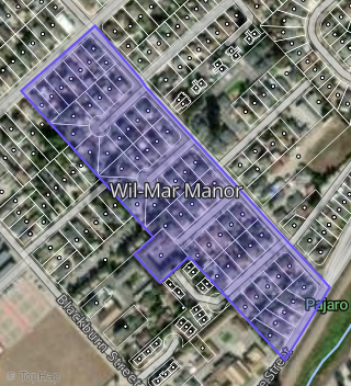
This property is located in Wil Mar Manor, Watsonville, CA 95076.
Seasonal Housing units 95076
51%of housing is for seasonal rent.
Daytime Population for 95076
-10%of people during work hours.
Boundary map of Wil-Mar Manor.
Crime Index for 95076
73
The crime index in 95076 is 73, which is 0.7 times lower than national average.
Market Trends
Historical market data near 452 Mckenzie Ct over selected time period.
Nearby Properties on Mckenzie Ct
- 443 Mckenzie Ct, Watsonville, CA 95076 (Wil-Mar Manor) is a 2,242 square foot, 4 bedroom, 4 bathroom, 0.13 acre property. It was built in 1951 and has an estimate of $864,486 with a price per ft² of $393.
- 439 Mckenzie Ct, Watsonville, CA 95076 (Wil-Mar Manor) is a 916 square foot, 2 bedroom, 1 bathroom, 0.12 acre property. It was built in 1950 and has an estimate of $676,843 with a price per ft² of $739.
- 435 Mckenzie Ct, Watsonville, CA 95076 (Wil-Mar Manor) is a 1,314 square foot, 2 bedroom, 1 bathroom, 0.2 acre property. It was built in 1951 and has an estimate of $597,597 with a price per ft² of $455.
- 431 Mckenzie Ct, Watsonville, CA 95076 (Wil-Mar Manor) is a 1,118 square foot, 3 bedroom, 1 bathroom, 0.2 acre property. It was built in 1951 and has an estimate of $756,138 with a price per ft² of $676.
- 447 Mckenzie Ct, Watsonville, CA 95076 (Wil-Mar Manor) is a 916 square foot, 2 bedroom, 1 bathroom, 0.13 acre property. It was built in 1951 and has an estimate of $672,422 with a price per ft² of $734.
- 451 Mckenzie Ct, Watsonville, CA 95076 (Wil-Mar Manor) is a 1,118 square foot, 3 bedroom, 1 bathroom, 0.15 acre property. It was built in 1951 and has an estimate of $692,896 with a price per ft² of $620.
- 440 Mckenzie Ct, Watsonville, CA 95076 (Wil-Mar Manor) is a 1,261 square foot, 2 bedroom, 1 bathroom, 0.12 acre property. It was built in 1951 and has an estimate of $578,133 with a price per ft² of $458.
- 436 Mckenzie Ct, Watsonville, CA 95076 (Wil-Mar Manor) is a 1,775 square foot, 4 bedroom, 2 bathroom, 0.19 acre property. It was built in 1950 and has an estimate of $784,405 with a price per ft² of $442.
- 432 Mckenzie Ct, Watsonville, CA 95076 (Wil-Mar Manor) is a 1,180 square foot, 2 bedroom, 1 bathroom, 0.2 acre property. It was built in 1951 and has an estimate of $633,307 with a price per ft² of $537.
- 444 Mckenzie Ct, Watsonville, CA 95076 (Wil-Mar Manor) is a 916 square foot, 2 bedroom, 1 bathroom, 0.13 acre property. It was built in 1951 and has an estimate of $676,354 with a price per ft² of $738.
- 448 Mckenzie Ct, Watsonville, CA 95076 (Wil-Mar Manor) is a 1,252 square foot, 3 bedroom, 1 bathroom, 0.13 acre property. It was built in 1951 and has an estimate of $660,113 with a price per ft² of $527.
- 452 Mckenzie Ct, Watsonville, CA 95076 (Wil-Mar Manor) is a 1,105 square foot, 3 bedroom, 1 bathroom, 0.15 acre property. It was built in 1951 and has an estimate of $686,897 with a price per ft² of $622.