533 Tallant Rd
Santa Barbara, CA 93105
- 3Beds
- 2Baths
- 1,649ft²Living Area
- 8,276ft²Lot Size
- -Pool
- -Car
- 1949Year Built
- -DOM
- 1Permit
Property Valuations
Latest estimates for 533 Tallant Rd based on TopHap automated valuation model (AVM).
TopHap Estimate
$1,893,250
$1,148/ft²
Updated 3 months ago
533 Tallant Rd is valued at $1,893,250 by TopHap AVM 3 months ago.
Permits
533 Tallant Rd has 1 permit records.
Current Ownership
Information about the current owner(s).
Taxes Billed
Taxes billed in 2023$1,261.96From latest Total Assessed Value1.03%Total Assessed Value$122,048=Land+
Assessed Value$33,678Additions
Assessed Value$88,370
In 2023, taxes billed for 533 Tallant Rd were $1,261.96, which is 1.03% from latest Total Assessed Value of $122,048.
Property History
533 Tallant Rd has undefined property events records (listings, deeds, permits, tax, foreclosure, loan).
Environment
Environmental factors around 533 Tallant Rd
Hazard Risks
Earthquake477Nat'l Avg100Lead100Particulates100Air Pollution100Carb Mono95Ozone95Tornado10Weather6Hurricane1Wind1Hail0
11 hazards (Carbon Monoxide, Earthquake Risk, Tornado Index, Hurricane Index, Air Pollution Index, Ozone Index, Wind Index, Weather Risk, Lead Index, Particulate Matter, National Average) are above the national average around 533 Tallant Rd.
Walkability Index
12 /20
Most Walkable
20-18
Very Walkable
17-15
Somewhat Walkable
14-10
Car Dependent
9-0
533 Tallant Rd has a walkability score of 12 out of 20, which means that it is in a somewhat walkable area.
Noise Level
59 dB
Quiet Suburban Residential 0-49
Suburban Residential 50-54
Urban Residential 55-59
Noisy Urban Residential 60-64
Very Noisy Urban Residential 65+
Noise at 533 Tallant Rd is around 59dBs, which is comparable to a Urban Residential area.
Temperature
Seasonal temperature sampled over multiple years
Winter
Average
Low
34°F
High
52°F
Summer
Average
Low
55°F
High
88°F
In the winter at 533 Tallant Rd, temperatures range from 34.45°F to 52.25°F with an average of 43.35°F. In the summer, the temperature ranges from 54.95°F to 87.52°F with and average of 71.24°F.
School Information
Public/private schools serving 533 Tallant Rd
Public Schools
Nearby public schools serving 533 Tallant Rd have ratings undefined, undefined, and undefined.
Neighborhood
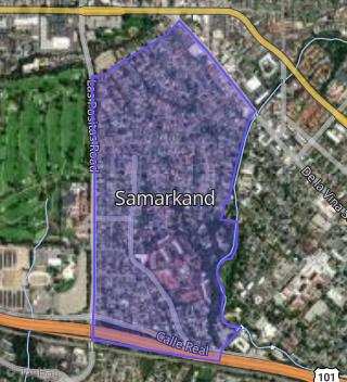
This property is located in Upper State, Santa Barbara, CA 93105.
Seasonal Housing units 93105
39%of housing is for seasonal rent.
Daytime Population for 93105
+20%of people during work hours.
Boundary map of Upper State.
Crime Index for 93105
99
The crime index in 93105 is 99, which is 1.0 times lower than national average.
Market Trends
Historical market data near 533 Tallant Rd over selected time period.
Nearby Properties on Tallant Rd
- 501 Tallant Rd, Santa Barbara, CA 93105 (Samarkand) is a 1,119 square foot, 2 bedroom, 2 bathroom, 0.19 acre property. It was built in 1948 and has an estimate of $1,405,754 with a price per ft² of $1,256.
- 2644 Tallant Rd, Santa Barbara, CA 93105 (Samarkand) is a 2,131 square foot, 3 bedroom, 2.25 bathroom, 0.25 acre property. It was built in 1925 and has an estimate of $2,290,422 with a price per ft² of $1,075.
- 2608 Tallant Rd, Santa Barbara, CA 93105 (Samarkand) is a 1,510 square foot, 2 bedroom, 2 bathroom, 0.23 acre property. It was built in 1959 and has an estimate of $1,631,844 with a price per ft² of $1,081.
- 524 Tallant Rd, Santa Barbara, CA 93105 (Samarkand) is a 2,059 square foot, 3 bedroom, 3.25 bathroom, 0.24 acre property. It was built in 1958 and has an estimate of $2,320,360 with a price per ft² of $1,127.
- 514 Tallant Rd, Santa Barbara, CA 93105 (Samarkand) is a 1,273 square foot, 3 bedroom, 2 bathroom, 0.24 acre property. It was built in 1957 and has an estimate of $1,636,686 with a price per ft² of $1,286.
- 2640 Tallant Rd, Santa Barbara, CA 93105 (Samarkand) is a 4,434 square foot, 6 bedroom, 6.25 bathroom, 1.07 acre property. It was built in 1925 and has an estimate of $5,168,852 with a price per ft² of $1,166.
- 2636 Tallant Rd, Santa Barbara, CA 93105 (Samarkand) is a 2,230 square foot, 4 bedroom, 3 bathroom, 0.49 acre property. It was built in 1910 and has an estimate of $2,610,464 with a price per ft² of $1,171.
- 2620 Tallant Rd, Santa Barbara, CA 93105 (Samarkand) is a 3,621 square foot, 3 bedroom, 4.25 bathroom, 0.89 acre property. It was built in 1949 and has an estimate of $4,744,446 with a price per ft² of $1,310.
- 515 Tallant Rd, Santa Barbara, CA 93105 (Samarkand) is a 1,688 square foot, 3 bedroom, 2 bathroom, 0.19 acre property. It was built in 1951 and has an estimate of $1,646,734 with a price per ft² of $976.
- 520 Tallant Rd, Santa Barbara, CA 93105 (Samarkand) is a 1,469 square foot, 3 bedroom, 2 bathroom, 0.24 acre property. It was built in 1958 and has an estimate of $1,652,534 with a price per ft² of $1,125.
- 530 Tallant Rd, Santa Barbara, CA 93105 (Samarkand) is a 1,312 square foot, 3 bedroom, 2 bathroom, 0.2 acre property. It was built in 1959 and has an estimate of $1,327,524 with a price per ft² of $1,012.
- 533 Tallant Rd, Santa Barbara, CA 93105 (Samarkand) is a 1,649 square foot, 3 bedroom, 2 bathroom, 0.19 acre property. It was built in 1949 and has an estimate of $1,615,129 with a price per ft² of $979.
- 430 Tallant Rd, Santa Barbara, CA 93105 (Samarkand) is a 1,679 square foot, 4 bedroom, 3 bathroom, 0.18 acre property. It was built in 1958 and has an estimate of $1,826,427 with a price per ft² of $1,088.
- 434 Tallant Rd, Santa Barbara, CA 93105 (Samarkand) is a 1,695 square foot, 3 bedroom, 2 bathroom, 0.19 acre property. It was built in 1958 and has an estimate of $1,763,172 with a price per ft² of $1,040.
- 414 Tallant Rd, Santa Barbara, CA 93105 (Samarkand) is a 2,235 square foot, 4 bedroom, 2 bathroom, 0.25 acre property. It was built in 1951 and has an estimate of $2,098,930 with a price per ft² of $939.
- 406 Tallant Rd, Santa Barbara, CA 93105 (Samarkand) is a 1,809 square foot, 3 bedroom, 3.25 bathroom, 0.35 acre property. It was built in 1948 and has an estimate of $2,167,897 with a price per ft² of $1,198.
- 2664 Tallant Rd, Santa Barbara, CA 93105 (Samarkand) is a 0.41 acre property.
- 2450 Tallant Rd, Santa Barbara, CA 93105 (Oak Park) is a 1,741 square foot, 3 bedroom, 2 bathroom, 0.17 acre property. It was built in 1970 and has an estimate of $1,926,295 with a price per ft² of $1,106.
- 2440 Tallant Rd, Santa Barbara, CA 93105 (Oak Park) is a 1,608 square foot, 3 bedroom, 2 bathroom, 0.26 acre property. It was built in 1962 and has an estimate of $1,781,716 with a price per ft² of $1,108.