550 C St
West Sacramento, CA 95605
- 6Beds
- 4Baths
- 2,496ft²Living Area
- 0.4acLot Size
- -Pool
- -Car
- 1923Year Built
- -DOM
- 7Permits
Property Valuations
Latest estimates for 550 C St based on TopHap automated valuation model (AVM).
TopHap Estimate
$704,000
$282/ft²
+$306K above Sold Price
Updated 3 months ago
Last Sold Price
$397,748
$159/ft²
3 years ago
550 C St is valued at $704,000 by TopHap AVM 3 months ago.
550 C St was last sold in 2020 for $397,748.
Permits
550 C St has 7 permit records of total value of $1,424,319.
Current Ownership
Information about the current owner(s).
Taxes Billed
Taxes billed in 2023$7,855.94From latest Total Assessed Value1.29%Total Assessed Value$608,634=Land+
Assessed Value$447,372Additions
Assessed Value$161,262
In 2023, taxes billed for 550 C St were $7,855.94, which is 1.29% from latest Total Assessed Value of $608,634.
Property History
550 C St has undefined property events records (listings, deeds, permits, tax, foreclosure, loan).
Environment
Environmental factors around 550 C St
Hazard Risks
Earthquake117Nat'l Avg100Particulates98Ozone89Air Pollution87Carb Mono84Lead44Tornado20Weather5Hail2Hurricane0Wind0
10 hazards (Carbon Monoxide, Earthquake Risk, Hail Index, Tornado Index, Air Pollution Index, Ozone Index, Weather Risk, Lead Index, Particulate Matter, National Average) are above the national average around 550 C St.
Walkability Index
15 /20
Most Walkable
20-18
Very Walkable
17-15
Somewhat Walkable
14-10
Car Dependent
9-0
550 C St has a walkability score of 15 out of 20, which means that it is in a very walkable area.
Noise Level
57 dB
Quiet Suburban Residential 0-49
Suburban Residential 50-54
Urban Residential 55-59
Noisy Urban Residential 60-64
Very Noisy Urban Residential 65+
Noise at 550 C St is around 57dBs, which is comparable to a Urban Residential area.
Temperature
Seasonal temperature sampled over multiple years
Winter
Average
Low
39°F
High
56°F
Summer
Average
Low
57°F
High
92°F
In the winter at 550 C St, temperatures range from 39.07°F to 56.07°F with an average of 47.57°F. In the summer, the temperature ranges from 57.24°F to 91.74°F with and average of 74.49°F.
School Information
Public/private schools serving 550 C St
Public Schools
Nearby public schools serving 550 C St have ratings undefined, and undefined.
Neighborhood
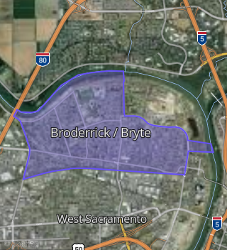
This property is located in Broderrick Bryte, West Sacramento, CA 95605.
Seasonal Housing units 95605
5%of housing is for seasonal rent.
Daytime Population for 95605
-18%of people during work hours.
Boundary map of Broderrick / Bryte.
Crime Index for 95605
122
The crime index in 95605 is 122, which is 1.2 times higher than national average.
Market Trends
Historical market data near 550 C St over selected time period.
Nearby Properties on C St
- 509 C St, West Sacramento, CA 95605 (Broderrick / Bryte) is a 2,106 square foot, 3 bedroom, 1 bathroom, 0.12 acre property. It was built in 1932 and has an estimate of $444,717 with a price per ft² of $211.
- 370 C St, West Sacramento, CA 95605 (Metro Place At Washington Square) is a 1,379 square foot, 2 bedroom, 2.25 bathroom, 0.02 acre property. It was built in 2003 and has an estimate of $492,339 with a price per ft² of $357.
- 320 C St, West Sacramento, CA 95605 (Metro Place At Washington Square) is a 1,592 square foot, 1 bedroom, 2.25 bathroom, 0.02 acre property. It was built in 2003 and has an estimate of $560,669 with a price per ft² of $352.
- 550 C St, West Sacramento, CA 95605 (Broderrick / Bryte) is a 2,496 square foot, 6 bedroom, 4.25 bathroom, 0.41 acre property. It was built in 1923 and has an estimate of $820,434 with a price per ft² of $329.
- 310 C St, West Sacramento, CA 95605 (Metro Place At Washington Square) is a 1,379 square foot, 1 bedroom, 2.25 bathroom, 0.02 acre property. It was built in 2003 and has an estimate of $490,537 with a price per ft² of $356.
- 350 C St, West Sacramento, CA 95605 (Metro Place At Washington Square) is a 1,379 square foot, 1 bedroom, 2.25 bathroom, 0.02 acre property. It was built in 2003 and has an estimate of $460,119 with a price per ft² of $334.
- 507 C St, West Sacramento, CA 95605 (Broderrick / Bryte) is a 1,050 square foot, 2 bedroom, 1 bathroom, 0.12 acre property. It was built in 1942 and has an estimate of $397,383 with a price per ft² of $378.
- 390 C St, West Sacramento, CA 95605 (Metro Place At Washington Square) is a 1,719 square foot, 2 bedroom, 2.25 bathroom, 0.03 acre property. It was built in 2003 and has an estimate of $616,019 with a price per ft² of $358.
- 380 C St, West Sacramento, CA 95605 (Metro Place At Washington Square) is a 1,379 square foot, 1 bedroom, 2 bathroom, 0.02 acre property. It was built in 2003 and has an estimate of $476,731 with a price per ft² of $346.
- 360 C St, West Sacramento, CA 95605 (Metro Place At Washington Square) is a 1,379 square foot, 1 bedroom, 2.25 bathroom, 0.02 acre property. It was built in 2003 and has an estimate of $486,348 with a price per ft² of $353.
- 340 C St, West Sacramento, CA 95605 (Metro Place At Washington Square) is a 1,379 square foot, 1 bedroom, 2.25 bathroom, 0.02 acre property. It was built in 2003 and has an estimate of $454,732 with a price per ft² of $330.
- 330 C St # 4, West Sacramento, CA 95605 (Metro Place At Washington Square) is a 1,379 square foot, 1 bedroom, 2.25 bathroom, 0.02 acre property. It was built in 2003 and has an estimate of $478,693 with a price per ft² of $347.
- 300 C St, West Sacramento, CA 95605 (Metro Place At Washington Square) is a 1,717 square foot, 2 bedroom, 2.25 bathroom, 0.03 acre property. It was built in 2003 and has an estimate of $593,502 with a price per ft² of $346.
- 347 C St # C, West Sacramento, CA 95605 (Metro Place At Washington Square) is a 1,326 square foot, 2 bedroom, 2 bathroom, 0.03 acre property. It was built in 2003 and has an estimate of $512,805 with a price per ft² of $387.
- 357 C St, West Sacramento, CA 95605 (Metro Place At Washington Square) is a 0.03 acre property. It has an estimate of $442,400.
- 500 C St, West Sacramento, CA 95605 (Broderrick / Bryte) is a 1,779 square foot and 0.28 acre property.
- 416 C St, West Sacramento, CA 95605 (Washington) is a 1,728 square foot, 2 bedroom, 1 bathroom, 0.08 acre property. It was built in 1912 and has an estimate of $429,621 with a price per ft² of $249.
- 418 C St, West Sacramento, CA 95605 (Washington) is a 2,388 square foot and 0.08 acre property.
- 400 C St, West Sacramento, CA 95605 (Washington) is a 1,734 square foot and 0.18 acre property.
- 412 C St, West Sacramento, CA 95605 (Washington) is a 0.09 acre property.
- 200 C St, West Sacramento, CA 95605 (Washington) is a 0.29 acre property.
- 511 C St, West Sacramento, CA 95605 (Broderrick / Bryte) is a 2,396 square foot, 4 bedroom, 2 bathroom, 0.08 acre property. It was built in 1924 and has an estimate of $563,826 with a price per ft² of $235.
- 519 C St, West Sacramento, CA 95605 (Broderrick / Bryte) is a 0.52 acre property.
- 221 C St, West Sacramento, CA 95605 (Washington) is a 0.29 acre property.
- 427 C St, West Sacramento, CA 95605 (Washington) is a 0.29 acre property.