605 Mcdonald Rd
Aptos, CA 95003
- 3Beds
- 2Baths
- 1,192ft²Living Area
- 0.4acLot Size
- -Pool
- 3Car
- -Year Built
- -DOM
- -Permit
Property Valuations
Latest estimates for 605 Mcdonald Rd based on TopHap automated valuation model (AVM).
TopHap Estimate
$2,875,000
$2,411/ft²
Updated 3 months ago
605 Mcdonald Rd is valued at $2,875,000 by TopHap AVM 3 months ago.
Current Ownership
Information about the current owner(s).
Taxes Billed
Taxes billed in 2023$1,210.68From latest Total Assessed Value1.43%Total Assessed Value$84,670=Land+
Assessed Value$23,460Additions
Assessed Value$61,210
In 2023, taxes billed for 605 Mcdonald Rd were $1,210.68, which is 1.43% from latest Total Assessed Value of $84,670.
Property History
605 Mcdonald Rd has undefined property events records (listings, deeds, permits, tax, foreclosure, loan).
Environment
Environmental factors around 605 Mcdonald Rd
Hazard Risks
Earthquake423Particulates101Nat'l Avg100Ozone84Air Pollution84Carb Mono73Lead42Tornado6Weather4Hail0Hurricane0Wind0
9 hazards (Carbon Monoxide, Earthquake Risk, Tornado Index, Air Pollution Index, Ozone Index, Weather Risk, Lead Index, Particulate Matter, National Average) are above the national average around 605 Mcdonald Rd.
Walkability Index
8 /20
Most Walkable
20-18
Very Walkable
17-15
Somewhat Walkable
14-10
Car Dependent
9-0
605 Mcdonald Rd has a walkability score of 8 out of 20, which means that it is in a car dependent area.
Noise Level
54 dB
Quiet Suburban Residential 0-49
Suburban Residential 50-54
Urban Residential 55-59
Noisy Urban Residential 60-64
Very Noisy Urban Residential 65+
Noise at 605 Mcdonald Rd is around 54dBs, which is comparable to a Suburban Residential area.
Temperature
Seasonal temperature sampled over multiple years
Winter
Average
Low
39°F
High
61°F
Summer
Average
Low
51°F
High
76°F
In the winter at 605 Mcdonald Rd, temperatures range from 39.34°F to 61.32°F with an average of 50.33°F. In the summer, the temperature ranges from 50.73°F to 76.44°F with and average of 63.59°F.
School Information
Public/private schools serving 605 Mcdonald Rd
Public Schools
Nearby public schools serving 605 Mcdonald Rd have ratings undefined, undefined, and undefined.
Neighborhood
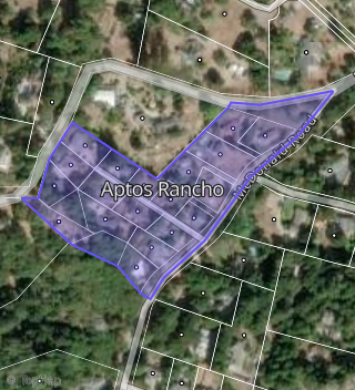
This property is located in Aptos Rancho, Aptos, CA 95003.
Seasonal Housing units 95003
70%of housing is for seasonal rent.
Daytime Population for 95003
-4%of people during work hours.
Boundary map of Aptos Rancho.
Crime Index for 95003
99
The crime index in 95003 is 99, which is 1.0 times lower than national average.
Market Trends
Historical market data near 605 Mcdonald Rd over selected time period.
Nearby Properties on Mcdonald Rd
- 479 Mcdonald Rd, Aptos, CA 95003 (Aptos Rancho) is a 1,674 square foot, 3 bedroom, 2 bathroom, 0.33 acre property. It was built in 1974 and has an estimate of $1,173,448 with a price per ft² of $701.
- 530 Mcdonald Rd, Aptos, CA 95003 is a 3,169 square foot, 4 bedroom, 4 bathroom, 1.07 acre property. It was built in 1978 and has an estimate of $1,521,978 with a price per ft² of $448.
- 540 Mcdonald Rd, Aptos, CA 95003 is a 2,508 square foot, 3 bedroom, 3 bathroom, 1.02 acre property. It was built in 1976 and has an estimate of $1,540,313 with a price per ft² of $570.
- 320 Mcdonald Rd, Aptos, CA 95003 is a 2,670 square foot, 5 bedroom, 3 bathroom, 8.31 acre property. It was built in 1999 and has an estimate of $1,883,110 with a price per ft² of $705.
- 361 Mcdonald Rd, Aptos, CA 95003 is a 2,648 square foot, 3 bedroom, 2 bathroom, 2.25 acre property. It was built in 2001 and has an estimate of $2,140,584 with a price per ft² of $808.
- 125 Mcdonald Rd, Aptos, CA 95003 is a 913 square foot, 2 bedroom, 1 bathroom, 0.52 acre property. It was built in 1925 and has an estimate of $966,617 with a price per ft² of $1,086.
- 575 Mcdonald Rd, Aptos, CA 95003 (Aptos Rancho) is a 2,328 square foot, 2 bedroom, 2 bathroom, 0.53 acre property. It was built in 1974 and has an estimate of $1,558,288 with a price per ft² of $669.
- 481 Mcdonald Rd, Aptos, CA 95003 (Aptos Rancho) is a 1,558 square foot, 3 bedroom, 2 bathroom, 0.32 acre property. It was built in 1973 and has an estimate of $1,135,815 with a price per ft² of $729.
- 501 Mcdonald Rd, Aptos, CA 95003 (Aptos Rancho) is a 1,418 square foot, 3 bedroom, 2 bathroom, 0.23 acre property. It was built in 1970 and has an estimate of $1,035,371 with a price per ft² of $730.
- 519 Mcdonald Rd, Aptos, CA 95003 (Aptos Rancho) is a 1,530 square foot, 3 bedroom, 2 bathroom, 0.35 acre property. It was built in 1972 and has an estimate of $1,143,049 with a price per ft² of $747.
- 535 Mcdonald Rd, Aptos, CA 95003 (Aptos Rancho) is a 2,465 square foot, 3 bedroom, 2 bathroom, 0.43 acre property. It was built in 1972 and has an estimate of $1,369,440 with a price per ft² of $556.
- 490 Mcdonald Rd, Aptos, CA 95003 is a 2,860 square foot, 5 bedroom, 3 bathroom, 1.15 acre property. It was built in 1982 and has an estimate of $1,554,471 with a price per ft² of $544.
- 331 Mcdonald Rd, Aptos, CA 95003 is a 2,548 square foot, 3 bedroom, 2 bathroom, 2.41 acre property. It was built in 2003 and has an estimate of $1,649,790 with a price per ft² of $647.
- 315 Mcdonald Rd, Aptos, CA 95003 is a 2,536 square foot, 4 bedroom, 3 bathroom, 2.07 acre property. It was built in 1989 and has an estimate of $1,644,311 with a price per ft² of $648.
- 285 Mcdonald Rd, Aptos, CA 95003 is a 3,449 square foot, 4 bedroom, 2 bathroom, 2.38 acre property. It was built in 1976 and has an estimate of $1,730,645 with a price per ft² of $502.
- 155 Mcdonald Rd, Aptos, CA 95003 is a 2,146 square foot, 3 bedroom, 2 bathroom, 3.64 acre property. It was built in 1995 and has an estimate of $1,479,681 with a price per ft² of $690.
- 115 Mcdonald Rd, Aptos, CA 95003 is a 1,568 square foot, 3 bedroom, 2 bathroom, 1.55 acre property. It was built in 2009 and has an estimate of $1,164,011 with a price per ft² of $742.
- 587 Mcdonald Rd, Aptos, CA 95003 (Aptos Rancho) is a 1,680 square foot, 4 bedroom, 2 bathroom, 0.41 acre property. It was built in 1976 and has an estimate of $1,195,139 with a price per ft² of $711.
- 605 Mcdonald Rd, Aptos, CA 95003 (Aptos Rancho) is a 1,192 square foot, 3 bedroom, 2 bathroom, 0.38 acre property. It has an estimate of $394,700 with a price per ft² of $331.
- 301 Mcdonald Rd, Aptos, CA 95003 is a 0.29 acre property. It has an estimate of $444,100.