6120 Hill Rd
Oakland, CA 94618
- 3Beds
- 2Baths
- 1,692ft²Living Area
- 4,180ft²Lot Size
- -Pool
- 1Car
- 1960Year Built
- -DOM
- 4Permits
Property Valuations
Latest estimates for 6120 Hill Rd based on TopHap automated valuation model (AVM).
TopHap Estimate
$1,452,506
$858/ft²
-$55K below Sold Price
Updated 3 months ago
Last Sold Price
$1,508,000
$891/ft²
8 months ago
6120 Hill Rd is valued at $1,452,506 by TopHap AVM 3 months ago.
6120 Hill Rd was last sold in 2023 for $1,508,000.
Permits
6120 Hill Rd has 4 permit records of total value of $1,001.
Current Ownership
Information about the current owner(s).
Taxes Billed
Taxes billed in 2023$8,975.76From latest Total Assessed Value1.7%Total Assessed Value$529,464=Land+
Assessed Value$158,839Additions
Assessed Value$370,625
In 2023, taxes billed for 6120 Hill Rd were $8,975.76, which is 1.70% from latest Total Assessed Value of $529,464.
Property History
6120 Hill Rd has undefined property events records (listings, deeds, permits, tax, foreclosure, loan).
Environment
Environmental factors around 6120 Hill Rd
Hazard Risks
Earthquake644Carb Mono101Nat'l Avg100Particulates100Ozone88Air Pollution84Lead39Tornado16Weather4Hail0Hurricane0Wind0
9 hazards (Carbon Monoxide, Earthquake Risk, Tornado Index, Air Pollution Index, Ozone Index, Weather Risk, Lead Index, Particulate Matter, National Average) are above the national average around 6120 Hill Rd.
Walkability Index
12 /20
Most Walkable
20-18
Very Walkable
17-15
Somewhat Walkable
14-10
Car Dependent
9-0
6120 Hill Rd has a walkability score of 12 out of 20, which means that it is in a somewhat walkable area.
Noise Level
40 dB
Quiet Suburban Residential 0-49
Suburban Residential 50-54
Urban Residential 55-59
Noisy Urban Residential 60-64
Very Noisy Urban Residential 65+
Noise at 6120 Hill Rd is around 40dBs, which is comparable to a Quiet Suburban Residential area.
Temperature
Seasonal temperature sampled over multiple years
Winter
Average
Low
42°F
High
57°F
Summer
Average
Low
54°F
High
72°F
In the winter at 6120 Hill Rd, temperatures range from 42.09°F to 57.13°F with an average of 49.61°F. In the summer, the temperature ranges from 53.85°F to 72.28°F with and average of 63.07°F.
School Information
Public/private schools serving 6120 Hill Rd
Public Schools
Nearby public schools serving 6120 Hill Rd have ratings undefined, and undefined.
Neighborhood
This property is located in Upper Rockridge, Oakland, CA 94618.
Seasonal Housing units 94618
15%of housing is for seasonal rent.
Daytime Population for 94618
+13%of people during work hours.
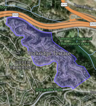
Boundary map of Upper Rockridge.
Crime Index for 94618
93
The crime index in 94618 is 93, which is 0.9 times lower than national average.
Market Trends
Historical market data near 6120 Hill Rd over selected time period.
Nearby Properties on Hill Rd
- 6155 Hill Rd, Oakland, CA 94618 (Rockridge Terrace) is a 3,548 square foot, 4 bedroom, 3.5 bathroom, 0.24 acre property. It was built in 1994 and has an estimate of $2,674,972 with a price per ft² of $754.
- 6175 Hill Rd, Oakland, CA 94618 (Rockridge Terrace) is a 2,341 square foot, 4 bedroom, 3.25 bathroom, 0.09 acre property. It was built in 1993 and has an estimate of $1,841,799 with a price per ft² of $787.
- 6133 Hill Rd, Oakland, CA 94618 (Rockridge Terrace) is a 3,206 square foot, 3 bedroom, 4.25 bathroom, 0.2 acre property. It was built in 1931 and has an estimate of $2,599,087 with a price per ft² of $811.
- 6141 Hill Rd, Oakland, CA 94618 (Rockridge Terrace) is a 920 square foot, 1 bedroom, 1 bathroom, 0.15 acre property. It was built in 1994 and has an estimate of $834,218 with a price per ft² of $907.
- 6149 Hill Rd, Oakland, CA 94618 (Rockridge Terrace) is a 2,280 square foot, 4 bedroom, 3 bathroom, 0.21 acre property. It was built in 1993 and has an estimate of $2,019,741 with a price per ft² of $886.
- 6161 Hill Rd, Oakland, CA 94618 (Rockridge Terrace) is a 3,691 square foot, 4 bedroom, 4 bathroom, 0.22 acre property. It was built in 1998 and has an estimate of $2,699,488 with a price per ft² of $562.
- 6167 Hill Rd, Oakland, CA 94618 (Rockridge Terrace) is a 2,752 square foot, 4 bedroom, 3.25 bathroom, 0.2 acre property. It was built in 1993 and has an estimate of $2,125,389 with a price per ft² of $772.
- 6148 Hill Rd, Oakland, CA 94618 (Rockridge Terrace) is a 4,681 square foot, 3 bedroom, 4.25 bathroom, 0.2 acre property. It was built in 1996 and has an estimate of $3,417,216 with a price per ft² of $730.
- 6120 Hill Rd, Oakland, CA 94618 (Rockridge Terrace) is a 1,692 square foot, 3 bedroom, 2.25 bathroom, 0.1 acre property. It was built in 1960 and has an estimate of $1,510,863 with a price per ft² of $893.