6515 Gwin Rd
Oakland, CA 94611
- 4Beds
- 5Baths
- 4,637ft²Living Area
- 0.3acLot Size
- -Pool
- 3Car
- 1996Year Built
- -DOM
- 9Permits
Property Valuations
Latest estimates for 6515 Gwin Rd based on TopHap automated valuation model (AVM).
TopHap Estimate
$2,760,000
$595/ft²
+$760K above Sold Price
Updated 3 months ago
Last Sold Price
$2,000,000
$431/ft²
10 years ago
6515 Gwin Rd is valued at $2,760,000 by TopHap AVM 3 months ago.
6515 Gwin Rd was last sold in 2013 for $2,000,000.
Permits
6515 Gwin Rd has 9 permit records of total value of $814,964.
Current Ownership
Information about the current owner(s).
Taxes Billed
Taxes billed in 2023$34,531.36From latest Total Assessed Value1.46%Total Assessed Value$2,367,140=Land+
Assessed Value$710,142Additions
Assessed Value$1,656,998
In 2023, taxes billed for 6515 Gwin Rd were $34,531.36, which is 1.46% from latest Total Assessed Value of $2,367,140.
Property History
6515 Gwin Rd has undefined property events records (listings, deeds, permits, tax, foreclosure, loan).
Environment
Environmental factors around 6515 Gwin Rd
Hazard Risks
Earthquake584Particulates101Nat'l Avg100Carb Mono99Ozone85Air Pollution84Lead43Tornado11Weather7Hail0Hurricane0Wind0
9 hazards (Carbon Monoxide, Earthquake Risk, Tornado Index, Air Pollution Index, Ozone Index, Weather Risk, Lead Index, Particulate Matter, National Average) are above the national average around 6515 Gwin Rd.
Walkability Index
10 /20
Most Walkable
20-18
Very Walkable
17-15
Somewhat Walkable
14-10
Car Dependent
9-0
6515 Gwin Rd has a walkability score of 10 out of 20, which means that it is in a somewhat walkable area.
Noise Level
38 dB
Quiet Suburban Residential 0-49
Suburban Residential 50-54
Urban Residential 55-59
Noisy Urban Residential 60-64
Very Noisy Urban Residential 65+
Noise at 6515 Gwin Rd is around 38dBs, which is comparable to a Quiet Suburban Residential area.
Temperature
Seasonal temperature sampled over multiple years
Winter
Average
Low
42°F
High
56°F
Summer
Average
Low
53°F
High
74°F
In the winter at 6515 Gwin Rd, temperatures range from 42.02°F to 56.44°F with an average of 49.23°F. In the summer, the temperature ranges from 53.42°F to 73.86°F with and average of 63.64°F.
School Information
Public/private schools serving 6515 Gwin Rd
Public Schools
Nearby public schools serving 6515 Gwin Rd have ratings undefined, undefined, and undefined.
Neighborhood
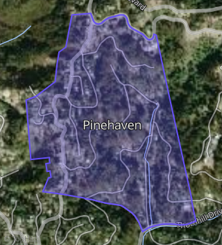
This property is located in Pinehaven, Oakland, CA 94611.
Seasonal Housing units 94611
9%of housing is for seasonal rent.
Daytime Population for 94611
+11%of people during work hours.
Boundary map of Pinehaven.
Crime Index for 94611
91
The crime index in 94611 is 91, which is 0.9 times lower than national average.
Market Trends
Historical market data near 6515 Gwin Rd over selected time period.
Nearby Properties on Gwin Rd
- 6550 Gwin Rd, Oakland, CA 94611 (Merriwood) is a 4,884 square foot, 5 bedroom, 4.25 bathroom, 0.94 acre property. It was built in 1997 and has an estimate of $3,095,613 with a price per ft² of $758.
- 6431 Gwin Rd, Oakland, CA 94611 (Pinehaven) is a 3,377 square foot, 3 bedroom, 3.25 bathroom, 0.14 acre property. It was built in 1998 and has an estimate of $1,874,418 with a price per ft² of $546.
- 6500 Gwin Rd, Oakland, CA 94611 (Pinehaven) is a 3,928 square foot, 3 bedroom, 4.25 bathroom, 0.25 acre property. It was built in 2000 and has an estimate of $2,473,200 with a price per ft² of $630.
- 6501 Gwin Rd, Oakland, CA 94611 (Pinehaven) is a 3,680 square foot, 4 bedroom, 5.25 bathroom, 0.32 acre property. It was built in 2007 and has an estimate of $2,600,782 with a price per ft² of $707.
- 6515 Gwin Rd, Oakland, CA 94611 (Pinehaven) is a 4,637 square foot, 4 bedroom, 5.25 bathroom, 0.31 acre property. It was built in 1996 and has an estimate of $2,809,176 with a price per ft² of $606.
- 6518 Gwin Rd, Oakland, CA 94611 (Pinehaven) is a 2,692 square foot, 4 bedroom, 3 bathroom, 0.25 acre property. It was built in 1994 and has an estimate of $1,734,773 with a price per ft² of $643.
- 6539 Gwin Rd, Oakland, CA 94611 (Merriwood) is a 3,710 square foot, 3 bedroom, 3 bathroom, 0.34 acre property. It was built in 1998 and has an estimate of $2,269,956 with a price per ft² of $473.
- 6429 Gwin Rd, Oakland, CA 94611 (Pinehaven) is a 4,147 square foot, 3 bedroom, 4.25 bathroom, 0.29 acre property. It was built in 1999 and has an estimate of $2,529,845 with a price per ft² of $610.
- 6400 Gwin Rd, Oakland, CA 94611 (Pinehaven) is a 3,062 square foot, 5 bedroom, 6.25 bathroom, 0.23 acre property. It was built in 1992 and has an estimate of $2,154,962 with a price per ft² of $970.
- 6534 Gwin Rd, Oakland, CA 94611 (Pinehaven) is a 1,852 square foot, 3 bedroom, 2 bathroom, 0.22 acre property. It was built in 1993 and has an estimate of $1,396,895 with a price per ft² of $754.
- 6538 Gwin Rd, Oakland, CA 94611 (Merriwood) is a 3,427 square foot, 4 bedroom, 4.25 bathroom, 0.2 acre property. It was built in 1993 and has an estimate of $2,026,271 with a price per ft² of $591.
- 6542 Gwin Rd, Oakland, CA 94611 (Merriwood) is a 3,559 square foot, 3 bedroom, 4.25 bathroom, 2.68 acre property. It was built in 2008 and has an estimate of $2,963,030 with a price per ft² of $833.
- 6511 Gwin Rd, Oakland, CA 94611 (Pinehaven) is a 2,848 square foot, 3 bedroom, 2.5 bathroom, 0.32 acre property. It was built in 1995 and has an estimate of $1,847,589 with a price per ft² of $649.
- 6447 Gwin Rd, Oakland, CA 94611 (Pinehaven) is a 4,771 square foot, 4 bedroom, 4.25 bathroom, 0.31 acre property. It was built in 1996 and has an estimate of $2,736,457 with a price per ft² of $574.