659 Kenwyn Rd
Oakland, CA 94610
- 4Beds
- 4Baths
- 2,715ft²Living Area
- 6,000ft²Lot Size
- -Pool
- -Car
- 1926Year Built
- -DOM
- 1Permit
Property Valuations
Latest estimates for 659 Kenwyn Rd based on TopHap automated valuation model (AVM).
TopHap Estimate
$1,928,250
$710/ft²
Updated 3 months ago
659 Kenwyn Rd is valued at $1,928,250 by TopHap AVM 3 months ago.
Permits
659 Kenwyn Rd has 1 permit records of total value of $1,200.
Current Ownership
Information about the current owner(s).
Taxes Billed
Taxes billed in 2023$3,015.86From latest Total Assessed Value3.05%Total Assessed Value$98,740=Land+
Assessed Value$53,965Additions
Assessed Value$44,775
In 2023, taxes billed for 659 Kenwyn Rd were $3,015.86, which is 3.05% from latest Total Assessed Value of $98,740.
Property History
659 Kenwyn Rd has undefined property events records (listings, deeds, permits, tax, foreclosure, loan).
Environment
Environmental factors around 659 Kenwyn Rd
Hazard Risks
Earthquake507Nat'l Avg100Carb Mono97Particulates97Air Pollution86Ozone85Lead43Tornado19Weather9Hail0Hurricane0Wind0
9 hazards (Carbon Monoxide, Earthquake Risk, Tornado Index, Air Pollution Index, Ozone Index, Weather Risk, Lead Index, Particulate Matter, National Average) are above the national average around 659 Kenwyn Rd.
Walkability Index
16 /20
Most Walkable
20-18
Very Walkable
17-15
Somewhat Walkable
14-10
Car Dependent
9-0
659 Kenwyn Rd has a walkability score of 16 out of 20, which means that it is in a very walkable area.
Noise Level
47 dB
Quiet Suburban Residential 0-49
Suburban Residential 50-54
Urban Residential 55-59
Noisy Urban Residential 60-64
Very Noisy Urban Residential 65+
Noise at 659 Kenwyn Rd is around 47dBs, which is comparable to a Quiet Suburban Residential area.
Temperature
Seasonal temperature sampled over multiple years
Winter
Average
Low
43°F
High
58°F
Summer
Average
Low
55°F
High
71°F
In the winter at 659 Kenwyn Rd, temperatures range from 43.09°F to 57.96°F with an average of 50.53°F. In the summer, the temperature ranges from 54.7°F to 71.44°F with and average of 63.07°F.
School Information
Public/private schools serving 659 Kenwyn Rd
Public Schools
Nearby public schools serving 659 Kenwyn Rd have ratings undefined, undefined, and undefined.
Neighborhood
This property is located in Cleveland Heights, Oakland, CA 94610.
Seasonal Housing units 94610
10%of housing is for seasonal rent.
Daytime Population for 94610
-17%of people during work hours.
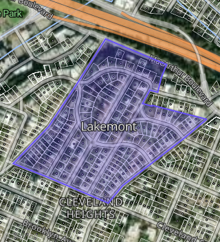
Boundary map of Cleveland Heights.
Crime Index for 94610
127
The crime index in 94610 is 127, which is 1.3 times higher than national average.
Market Trends
Historical market data near 659 Kenwyn Rd over selected time period.
Nearby Properties on Kenwyn Rd
- 594 Kenwyn Rd, Oakland, CA 94610 (Lakemont) is a 1,749 square foot, 3 bedroom, 2 bathroom, 0.07 acre property. It was built in 1925 and has an estimate of $1,266,270 with a price per ft² of $763.
- 662 Kenwyn Rd, Oakland, CA 94610 (Loma Vista) is a 3,782 square foot, 4 bedroom, 3 bathroom, 0.12 acre property. It was built in 1917 and has an estimate of $1,942,087 with a price per ft² of $514.
- 577 Kenwyn Rd, Oakland, CA 94610 (Lakemont) is a 1,296 square foot, 2 bedroom, 1 bathroom, 0.09 acre property. It was built in 1924 and has an estimate of $1,212,084 with a price per ft² of $935.
- 578 Kenwyn Rd, Oakland, CA 94610 (Lakemont) is a 2,159 square foot, 4 bedroom, 2 bathroom, 0.09 acre property. It was built in 1924 and has an estimate of $1,415,425 with a price per ft² of $656.
- 630 Kenwyn Rd, Oakland, CA 94610 (Lakemont) is a 3,596 square foot, 4 bedroom, 5.25 bathroom, 0.14 acre property. It was built in 1926 and has an estimate of $2,433,600 with a price per ft² of $677.
- 633 Kenwyn Rd, Oakland, CA 94610 (Lakemont) is a 1,854 square foot, 3 bedroom, 2.25 bathroom, 0.11 acre property. It was built in 1922 and has an estimate of $1,465,793 with a price per ft² of $791.
- 659 Kenwyn Rd, Oakland, CA 94610 (Lakemont) is a 2,715 square foot, 4 bedroom, 3.5 bathroom, 0.14 acre property. It was built in 1926 and has an estimate of $2,001,902 with a price per ft² of $737.
- 618 Kenwyn Rd, Oakland, CA 94610 (Lakemont) is a 2,268 square foot, 4 bedroom, 3.25 bathroom, 0.12 acre property. It was built in 1925 and has an estimate of $1,579,278 with a price per ft² of $696.
- 600 Kenwyn Rd, Oakland, CA 94610 (Lakemont) is a 2,914 square foot, 4 bedroom, 3 bathroom, 0.13 acre property. It was built in 1925 and has an estimate of $2,095,896 with a price per ft² of $719.
- 631 Kenwyn Rd, Oakland, CA 94610 (Lakemont) is a 2,161 square foot, 3 bedroom, 2 bathroom, 0.11 acre property. It was built in 1927 and has an estimate of $1,621,136 with a price per ft² of $750.
- 617 Kenwyn Rd, Oakland, CA 94610 (Lakemont) is a 1,879 square foot, 3 bedroom, 2.25 bathroom, 0.11 acre property. It was built in 1924 and has an estimate of $1,418,533 with a price per ft² of $755.
- 590 Kenwyn Rd, Oakland, CA 94610 (Lakemont) is a 2,315 square foot, 3 bedroom, 2 bathroom, 0.11 acre property. It was built in 1923 and has an estimate of $1,514,850 with a price per ft² of $654.
- 586 Kenwyn Rd, Oakland, CA 94610 (Lakemont) is a 1,519 square foot, 3 bedroom, 1 bathroom, 0.1 acre property. It was built in 1923 and has an estimate of $1,191,658 with a price per ft² of $785.
- 582 Kenwyn Rd, Oakland, CA 94610 (Lakemont) is a 2,117 square foot, 3 bedroom, 2.25 bathroom, 0.1 acre property. It was built in 1925 and has an estimate of $1,586,343 with a price per ft² of $749.
- 550 Kenwyn Rd, Oakland, CA 94610 (Lakemont) is a 1,136 square foot, 2 bedroom, 1 bathroom, 0.09 acre property. It was built in 1950 and has an estimate of $931,637 with a price per ft² of $820.
- 556 Kenwyn Rd, Oakland, CA 94610 (Lakemont) is a 1,548 square foot, 3 bedroom, 2 bathroom, 0.1 acre property. It was built in 1923 and has an estimate of $1,285,274 with a price per ft² of $830.
- 562 Kenwyn Rd, Oakland, CA 94610 (Lakemont) is a 1,833 square foot, 3 bedroom, 1 bathroom, 0.1 acre property. It was built in 1930 and has an estimate of $1,418,040 with a price per ft² of $774.
- 568 Kenwyn Rd, Oakland, CA 94610 (Lakemont) is a 1,321 square foot, 3 bedroom, 1 bathroom, 0.1 acre property. It was built in 1925 and has an estimate of $1,190,634 with a price per ft² of $901.
- 574 Kenwyn Rd, Oakland, CA 94610 (Lakemont) is a 2,331 square foot, 3 bedroom, 2 bathroom, 0.1 acre property. It was built in 1923 and has an estimate of $1,596,804 with a price per ft² of $685.
- 650 Kenwyn Rd, Oakland, CA 94610 (Lakemont) is a 5,853 square foot, 5 bedroom, 4.5 bathroom, 0.27 acre property. It was built in 1922 and has an estimate of $2,608,869 with a price per ft² of $446.
- 567 Kenwyn Rd, Oakland, CA 94610 (Lakemont) is a 2,202 square foot, 3 bedroom, 3.25 bathroom, 0.09 acre property. It was built in 1923 and has an estimate of $1,346,427 with a price per ft² of $611.
- 561 Kenwyn Rd, Oakland, CA 94610 (Lakemont) is a 1,643 square foot, 3 bedroom, 2.25 bathroom, 0.09 acre property. It was built in 1925 and has an estimate of $1,111,656 with a price per ft² of $677.
- 551 Kenwyn Rd, Oakland, CA 94610 (Lakemont) is a 1,578 square foot, 2 bedroom, 2.25 bathroom, 0.11 acre property. It was built in 1926 and has an estimate of $1,242,867 with a price per ft² of $788.
- 651 Kenwyn Rd, Oakland, CA 94610 (Lakemont) is a 2,509 square foot, 4 bedroom, 3 bathroom, 0.14 acre property. It was built in 1919 and has an estimate of $1,885,909 with a price per ft² of $752.
- 641 Kenwyn Rd, Oakland, CA 94610 (Lakemont) is a 2,292 square foot, 3 bedroom, 2.25 bathroom, 0.11 acre property. It was built in 1927 and has an estimate of $1,631,841 with a price per ft² of $712.
- View more properties on Kenwyn Rd