712 Koval Ln
Santa Maria, CA 93455
- 3Beds
- 2Baths
- 1,654ft²Living Area
- 6,534ft²Lot Size
- -Pool
- -Car
- 1994Year Built
- -DOM
- -Permit
Property Valuations
Latest estimates for 712 Koval Ln based on TopHap automated valuation model (AVM).
TopHap Estimate
$638,750
$386/ft²
+$477K above Sold Price
Updated 3 months ago
Last Sold Price
$162,000
$98/ft²
29 years ago
712 Koval Ln is valued at $638,750 by TopHap AVM 3 months ago.
712 Koval Ln was last sold in 1995 for $162,000.
Current Ownership
Information about the current owner(s).
Taxes Billed
Taxes billed in 2023$3,040.50From latest Total Assessed Value1.16%Total Assessed Value$261,349=Land+
Assessed Value$137,212Additions
Assessed Value$124,137
In 2023, taxes billed for 712 Koval Ln were $3,040.5, which is 1.16% from latest Total Assessed Value of $261,349.
Property History
712 Koval Ln has undefined property events records (listings, deeds, permits, tax, foreclosure, loan).
Environment
Environmental factors around 712 Koval Ln
Hazard Risks
Earthquake272Nat'l Avg100Particulates96Air Pollution92Ozone91Lead89Carb Mono69Tornado3Weather2Hail0Hurricane0Wind0
9 hazards (Carbon Monoxide, Earthquake Risk, Tornado Index, Air Pollution Index, Ozone Index, Weather Risk, Lead Index, Particulate Matter, National Average) are above the national average around 712 Koval Ln.
Walkability Index
14 /20
Most Walkable
20-18
Very Walkable
17-15
Somewhat Walkable
14-10
Car Dependent
9-0
712 Koval Ln has a walkability score of 14 out of 20, which means that it is in a somewhat walkable area.
Temperature
Seasonal temperature sampled over multiple years
Winter
Average
Low
40°F
High
63°F
Summer
Average
Low
52°F
High
74°F
In the winter at 712 Koval Ln, temperatures range from 39.88°F to 62.9°F with an average of 51.39°F. In the summer, the temperature ranges from 52.16°F to 74.2°F with and average of 63.18°F.
School Information
Public/private schools serving 712 Koval Ln
Public Schools
Nearby public schools serving 712 Koval Ln have ratings undefined, undefined, and undefined.
Neighborhood
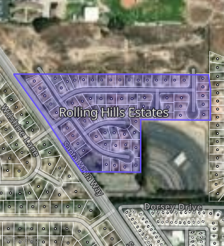
This property is located in Rolling Hills Estates, Santa Maria, CA 93455.
Seasonal Housing units 93455
19%of housing is for seasonal rent.
Daytime Population for 93455
-9%of people during work hours.
Boundary map of Rolling Hills Estates.
Crime Index for 93455
52
The crime index in 93455 is 52, which is 0.5 times lower than national average.
Market Trends
Historical market data near 712 Koval Ln over selected time period.
Nearby Properties on Koval Ln
- 745 Koval Ln, Santa Maria, CA 93455 (Rolling Hills Estates) is a 2,021 square foot, 3 bedroom, 2 bathroom, 0.15 acre property. It was built in 1993 and has an estimate of $620,744 with a price per ft² of $307.
- 769 Koval Ln, Santa Maria, CA 93455 (Rolling Hills Estates) is a 1,961 square foot, 3 bedroom, 2 bathroom, 0.15 acre property. It was built in 1996 and has an estimate of $631,499 with a price per ft² of $322.
- 746 Koval Ln, Santa Maria, CA 93455 (Rolling Hills Estates) is a 1,840 square foot, 3 bedroom, 3.25 bathroom, 0.15 acre property. It was built in 1994 and has an estimate of $532,985 with a price per ft² of $290.
- 702 Koval Ln, Santa Maria, CA 93455 (Rolling Hills Estates) is a 1,761 square foot, 3 bedroom, 2 bathroom, 0.16 acre property. It was built in 1995 and has an estimate of $598,634 with a price per ft² of $340.
- 724 Koval Ln, Santa Maria, CA 93455 (Rolling Hills Estates) is a 1,834 square foot, 3 bedroom, 2 bathroom, 0.16 acre property. It was built in 1996 and has an estimate of $628,252 with a price per ft² of $343.
- 751 Koval Ln, Santa Maria, CA 93455 (Rolling Hills Estates) is a 2,188 square foot, 3 bedroom, 2 bathroom, 0.15 acre property. It was built in 1996 and has an estimate of $705,016 with a price per ft² of $322.
- 787 Koval Ln, Santa Maria, CA 93455 (Rolling Hills Estates) is a 2,149 square foot, 3 bedroom, 2 bathroom, 0.16 acre property. It was built in 1997 and has an estimate of $705,996 with a price per ft² of $329.
- 775 Koval Ln, Santa Maria, CA 93455 (Rolling Hills Estates) is a 1,989 square foot, 3 bedroom, 2 bathroom, 0.15 acre property. It was built in 1993 and has an estimate of $608,530 with a price per ft² of $306.
- 781 Koval Ln, Santa Maria, CA 93455 (Rolling Hills Estates) is a 1,975 square foot, 3 bedroom, 2 bathroom, 0.15 acre property. It was built in 1994 and has an estimate of $647,736 with a price per ft² of $328.
- 763 Koval Ln, Santa Maria, CA 93455 (Rolling Hills Estates) is a 2,035 square foot, 3 bedroom, 2 bathroom, 0.15 acre property. It was built in 1994 and has an estimate of $654,515 with a price per ft² of $322.
- 784 Koval Ln, Santa Maria, CA 93455 (Rolling Hills Estates) is a 2,493 square foot, 4 bedroom, 3 bathroom, 0.16 acre property. It was built in 1994 and has an estimate of $764,761 with a price per ft² of $307.
- 721 Koval Ln, Santa Maria, CA 93455 (Rolling Hills Estates) is a 2,044 square foot, 3 bedroom, 2 bathroom, 0.15 acre property. It was built in 1995 and has an estimate of $656,054 with a price per ft² of $321.
- 712 Koval Ln, Santa Maria, CA 93455 (Rolling Hills Estates) is a 1,654 square foot, 3 bedroom, 2 bathroom, 0.15 acre property. It was built in 1994 and has an estimate of $571,949 with a price per ft² of $346.
- 732 Koval Ln, Santa Maria, CA 93455 (Rolling Hills Estates) is a 1,840 square foot, 3 bedroom, 2 bathroom, 0.15 acre property. It was built in 1995 and has an estimate of $587,683 with a price per ft² of $319.
- 740 Koval Ln, Santa Maria, CA 93455 (Rolling Hills Estates) is a 1,840 square foot, 3 bedroom, 2 bathroom, 0.15 acre property. It was built in 1993 and has an estimate of $580,520 with a price per ft² of $316.
- 752 Koval Ln, Santa Maria, CA 93455 (Rolling Hills Estates) is a 1,840 square foot, 3 bedroom, 2 bathroom, 0.15 acre property. It was built in 1993 and has an estimate of $572,272 with a price per ft² of $311.
- 739 Koval Ln, Santa Maria, CA 93455 (Rolling Hills Estates) is a 1,961 square foot, 3 bedroom, 2 bathroom, 0.15 acre property. It was built in 1993 and has an estimate of $613,943 with a price per ft² of $313.
- 733 Koval Ln, Santa Maria, CA 93455 (Rolling Hills Estates) is a 2,021 square foot, 3 bedroom, 2 bathroom, 0.15 acre property. It was built in 1993 and has an estimate of $625,193 with a price per ft² of $309.
- 727 Koval Ln, Santa Maria, CA 93455 (Rolling Hills Estates) is a 1,961 square foot, 3 bedroom, 2 bathroom, 0.15 acre property. It was built in 1993 and has an estimate of $596,814 with a price per ft² of $304.
- 715 Koval Ln, Santa Maria, CA 93455 (Rolling Hills Estates) is a 1,654 square foot, 3 bedroom, 2 bathroom, 0.15 acre property. It was built in 1994 and has an estimate of $577,233 with a price per ft² of $349.
- 709 Koval Ln, Santa Maria, CA 93455 (Rolling Hills Estates) is a 1,658 square foot, 2 bedroom, 2 bathroom, 0.16 acre property. It was built in 1995 and has an estimate of $544,811 with a price per ft² of $329.
- 703 Koval Ln, Santa Maria, CA 93455 (Rolling Hills Estates) is a 1,961 square foot, 3 bedroom, 2 bathroom, 0.16 acre property. It was built in 1995 and has an estimate of $639,344 with a price per ft² of $326.
- 757 Koval Ln, Santa Maria, CA 93455 (Rolling Hills Estates) is a 1,975 square foot, 3 bedroom, 2 bathroom, 0.15 acre property. It was built in 1993 and has an estimate of $609,870 with a price per ft² of $309.