75 482 Nani Kailua Dr
Kailua Kona, HI 96740
- 3Beds
- 4Baths
- 3,088ft²Living Area
- 1acLot Size
- 1Pool
- 2Car
- 2015Year Built
- -DOM
- -Permit
Property Valuations
Latest estimates for 75 482 Nani Kailua Dr based on TopHap automated valuation model (AVM).
TopHap Estimate
$2,548,073
$825/ft²
+$3M above Sold Price
Updated 3 months ago
Last Sold Price
$1,000
$0/ft²
20 months ago
75 482 Nani Kailua Dr is valued at $2,548,073 by TopHap AVM 3 months ago.
75 482 Nani Kailua Dr was last sold in 2022 for $1,000.
Current Ownership
Information about the current owner(s).
Taxes Billed
Taxes billed in 2023$100.00From latest Total Assessed Value0.01%Total Assessed Value$1,815,000=Land+
Assessed Value$350,000Additions
Assessed Value$1,465,000
In 2023, taxes billed for 75 482 Nani Kailua Dr were $100, which is 0.01% from latest Total Assessed Value of $1,815,000.
Property History
75 482 Nani Kailua Dr has undefined property events records (listings, deeds, permits, tax, foreclosure, loan).
Environment
Environmental factors around 75 482 Nani Kailua Dr
Hazard Risks
Carb Mono161Nat'l Avg100Ozone96Particulates94Air Pollution94Lead46Hurricane25Weather15Earthquake0Hail0Tornado0Wind0
8 hazards (Carbon Monoxide, Hurricane Index, Air Pollution Index, Ozone Index, Weather Risk, Lead Index, Particulate Matter, National Average) are above the national average around 75 482 Nani Kailua Dr.
Walkability Index
6 /20
Most Walkable
20-18
Very Walkable
17-15
Somewhat Walkable
14-10
Car Dependent
9-0
75 482 Nani Kailua Dr has a walkability score of 6 out of 20, which means that it is in a car dependent area.
Temperature
Seasonal temperature sampled over multiple years
Winter
Average
Low
55°F
High
74°F
Summer
Average
Low
60°F
High
77°F
In the winter at 75 482 Nani Kailua Dr, temperatures range from 54.64°F to 73.52°F with an average of 64.08°F. In the summer, the temperature ranges from 60.11°F to 77.39°F with and average of 68.75°F.
School Information
Public/private schools serving 75 482 Nani Kailua Dr
Public Schools
Nearby public schools serving 75 482 Nani Kailua Dr have ratings undefined, undefined, undefined, undefined, and undefined.
Neighborhood
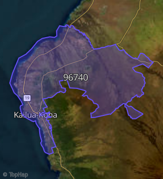
This property is located in Holualoa.
Seasonal Housing units 96740
43%of housing is for seasonal rent.
Daytime Population for 96740
+8%of people during work hours.
Boundary map of Holualoa.
Crime Index for 96740
111
The crime index in 96740 is 111, which is 1.1 times higher than national average.
Market Trends
Historical market data near 75 482 Nani Kailua Dr over selected time period.
Nearby Properties on Nani Kailua Dr
- 75-234 Nani Kailua Dr #Apt 85, Kailua Kona, HI 96740 is a 956 square foot, 2 bedroom, 2 bathroom, 0.02 acre property. It was built in 1989 and has an estimate of $722,226 with a price per ft² of $755.
- 75-348 Nani Kailua Dr, Kailua Kona, HI 96740 (Kailua View Estates) is a 1,620 square foot, 3 bedroom, 2 bathroom, 0.34 acre property. It was built in 1980 and has an estimate of $732,900 with a price per ft² of $452.
- 75-344 Nani Kailua Dr, Kailua Kona, HI 96740 (Kailua View Estates) is a 2,581 square foot, 3 bedroom, 2 bathroom, 0.35 acre property. It was built in 1980 and has an estimate of $1,119,068 with a price per ft² of $434.
- 75-357 Nani Kailua Dr, Kailua Kona, HI 96740 (Kailua View Estates) is a 2,352 square foot, 3 bedroom, 3 bathroom, 0.38 acre property. It was built in 1988 and has an estimate of $1,211,845 with a price per ft² of $515.
- 75-371 Nani Kailua Dr, Kailua Kona, HI 96740 (Kailua View Estates) is a 1,186 square foot, 2 bedroom, 2 bathroom, 0.36 acre property. It was built in 1984 and has an estimate of $830,857 with a price per ft² of $701.
- 75-418 Nani Kailua Dr, Kailua Kona, HI 96740 (Kailua View Estates) is a 2,198 square foot, 3 bedroom, 3 bathroom, 0.46 acre property. It was built in 2004 and has an estimate of $1,350,446 with a price per ft² of $614.
- 75-489 Nani Kailua Dr, Kailua Kona, HI 96740 is a 2,742 square foot, 4 bedroom, 5.25 bathroom, 1.01 acre property. It was built in 2015 and has an estimate of $2,471,031 with a price per ft² of $901.
- 75-482 Nani Kailua Dr, Kailua Kona, HI 96740 is a 3,089 square foot, 3 bedroom, 4.25 bathroom, 1.02 acre property. It was built in 2015 and has an estimate of $1,993,917 with a price per ft² of $645.
- 75-233 Nani Kailua Dr #Apt 97, Kailua Kona, HI 96740 is a 1,209 square foot, 3 bedroom, 2 bathroom, 0.03 acre property. It was built in 1990 and has an estimate of $925,939 with a price per ft² of $766.
- 75-233 Nani Kailua Dr #Apt 112, Kailua Kona, HI 96740 is a 956 square foot, 2 bedroom, 2 bathroom, 0.02 acre property. It was built in 1990 and has an estimate of $723,656 with a price per ft² of $757.
- 75-217 Nani Kailua Dr #Apt 139, Kailua Kona, HI 96740 is a 1,084 square foot, 2 bedroom, 2 bathroom, 0.02 acre property. It was built in 1990 and has an estimate of $779,552 with a price per ft² of $719.
- 75-217 Nani Kailua Dr #Apt 146, Kailua Kona, HI 96740 is a 1,004 square foot, 2 bedroom, 2 bathroom, 0.02 acre property. It was built in 1990 and has an estimate of $754,528 with a price per ft² of $752.
- 75-217 Nani Kailua Dr #Apt 153, Kailua Kona, HI 96740 is a 1,084 square foot, 2 bedroom, 2 bathroom, 0.02 acre property. It was built in 1990 and has an estimate of $779,552 with a price per ft² of $719.
- 75-217 Nani Kailua Dr #Apt 157, Kailua Kona, HI 96740 is a 1,084 square foot, 2 bedroom, 2 bathroom, 0.02 acre property. It was built in 1990 and has an estimate of $779,552 with a price per ft² of $719.
- 75-217 Nani Kailua Dr #Apt 163, Kailua Kona, HI 96740 is a 1,209 square foot, 3 bedroom, 2 bathroom, 0.03 acre property. It was built in 1990 and has an estimate of $925,939 with a price per ft² of $766.
- 75-217 Nani Kailua Dr #Apt 172, Kailua Kona, HI 96740 is a 1,209 square foot, 3 bedroom, 2 bathroom, 0.03 acre property. It was built in 1990 and has an estimate of $915,150 with a price per ft² of $757.
- 75-217 Nani Kailua Dr #Apt 176, Kailua Kona, HI 96740 is a 1,084 square foot, 2 bedroom, 2 bathroom, 0.02 acre property. It was built in 1990 and has an estimate of $779,552 with a price per ft² of $719.
- 75-217 Nani Kailua Dr #Apt 191, Kailua Kona, HI 96740 is a 1,209 square foot, 3 bedroom, 2 bathroom, 0.03 acre property. It was built in 1990 and has an estimate of $915,150 with a price per ft² of $757.
- 75-234 Nani Kailua Dr #Apt 53, Kailua Kona, HI 96740 is a 1,084 square foot, 2 bedroom, 2 bathroom, 0.02 acre property. It was built in 1989 and has an estimate of $725,664 with a price per ft² of $669.
- 75-234 Nani Kailua Dr #Apt 77, Kailua Kona, HI 96740 is a 1,004 square foot, 2 bedroom, 2 bathroom, 0.02 acre property. It was built in 1989 and has an estimate of $739,753 with a price per ft² of $737.
- 75-234 Nani Kailua Dr #Apt 81, Kailua Kona, HI 96740 is a 956 square foot, 2 bedroom, 2 bathroom, 0.02 acre property. It was built in 1989 and has an estimate of $722,226 with a price per ft² of $755.
- 75-311 Nani Kailua Dr, Kailua Kona, HI 96740 (Kailua View Estates) is a 1,728 square foot, 5 bedroom, 3.25 bathroom, 0.38 acre property. It was built in 1980 and has an estimate of $1,078,676 with a price per ft² of $624.
- 75-353 Nani Kailua Dr, Kailua Kona, HI 96740 (Kailua View Estates) is a 2,296 square foot, 3 bedroom, 2 bathroom, 0.4 acre property. It was built in 2005 and has an estimate of $1,152,952 with a price per ft² of $502.
- 75-397 Nani Kailua Dr, Kailua Kona, HI 96740 (Kailua View Estates) is a 1,248 square foot, 3 bedroom, 2 bathroom, 0.36 acre property. It was built in 1985 and has an estimate of $819,368 with a price per ft² of $657.
- 75-387 Nani Kailua Dr, Kailua Kona, HI 96740 (Kailua View Estates) is a 0.71 acre property. It has an estimate of $462,900.
- View more properties on Nani Kailua-Dr