933 Silverado Dr
Woodland, CA 95695
- 3Beds
- 2Baths
- 2,167ft²Living Area
- 0.3acLot Size
- 1Pool
- 2Car
- 1994Year Built
- -DOM
- -Permit
Property Valuations
Latest estimates for 933 Silverado Dr based on TopHap automated valuation model (AVM).
TopHap Estimate
$610,500
$281/ft²
+$462K above Sold Price
Updated 3 months ago
Last Sold Price
$148,750
$69/ft²
25 years ago
933 Silverado Dr is valued at $610,500 by TopHap AVM 3 months ago.
933 Silverado Dr was last sold in 1998 for $148,750.
Current Ownership
Information about the current owner(s).
Taxes Billed
Taxes billed in 2023$4,876.94From latest Total Assessed Value1.05%Total Assessed Value$463,871=Land+
Assessed Value$165,738Additions
Assessed Value$298,133
In 2023, taxes billed for 933 Silverado Dr were $4,876.94, which is 1.05% from latest Total Assessed Value of $463,871.
Property History
933 Silverado Dr has undefined property events records (listings, deeds, permits, tax, foreclosure, loan).
Environment
Environmental factors around 933 Silverado Dr
Hazard Risks
Earthquake171Nat'l Avg100Particulates93Ozone85Air Pollution84Carb Mono74Lead43Hail2Tornado2Weather1Hurricane0Wind0
10 hazards (Carbon Monoxide, Earthquake Risk, Hail Index, Tornado Index, Air Pollution Index, Ozone Index, Weather Risk, Lead Index, Particulate Matter, National Average) are above the national average around 933 Silverado Dr.
Walkability Index
17 /20
Most Walkable
20-18
Very Walkable
17-15
Somewhat Walkable
14-10
Car Dependent
9-0
933 Silverado Dr has a walkability score of 17 out of 20, which means that it is in a very walkable area.
Temperature
Seasonal temperature sampled over multiple years
Winter
Average
Low
38°F
High
56°F
Summer
Average
Low
57°F
High
93°F
In the winter at 933 Silverado Dr, temperatures range from 38.36°F to 56.43°F with an average of 47.4°F. In the summer, the temperature ranges from 57.1°F to 92.85°F with and average of 74.98°F.
School Information
Public/private schools serving 933 Silverado Dr
Public Schools
Nearby public schools serving 933 Silverado Dr have ratings undefined, undefined, and undefined.
Neighborhood
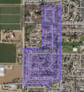
This property is located in Faria Park, Woodland, CA 95695.
Seasonal Housing units 95695
9%of housing is for seasonal rent.
Daytime Population for 95695
-13%of people during work hours.
Boundary map of Faria Park.
Crime Index for 95695
106
The crime index in 95695 is 106, which is 1.1 times higher than national average.
Market Trends
Historical market data near 933 Silverado Dr over selected time period.
Nearby Properties on Silverado Dr
- 1106 Silverado Dr, Woodland, CA 95695 (Faria Park) is a 2,388 square foot, 4 bedroom, 3 bathroom, 0.23 acre property. It was built in 1996 and has an estimate of $784,092 with a price per ft² of $328.
- 1050 Silverado Dr, Woodland, CA 95695 (Faria Park) is a 1,797 square foot, 3 bedroom, 2 bathroom, 0.23 acre property. It was built in 1994 and has an estimate of $575,972 with a price per ft² of $321.
- 1105 Silverado Dr, Woodland, CA 95695 (Faria Park) is a 2,670 square foot, 4 bedroom, 3 bathroom, 0.3 acre property. It was built in 1994 and has an estimate of $841,647 with a price per ft² of $315.
- 917 Silverado Dr, Woodland, CA 95695 (Faria Park) is a 2,676 square foot, 4 bedroom, 4.25 bathroom, 0.25 acre property. It was built in 1995 and has an estimate of $887,864 with a price per ft² of $301.
- 1115 Silverado Dr, Woodland, CA 95695 (Faria Park) is a 1,890 square foot, 3 bedroom, 2 bathroom, 0.21 acre property. It was built in 1995 and has an estimate of $661,556 with a price per ft² of $350.
- 1100 Silverado Dr, Woodland, CA 95695 (Faria Park) is a 2,307 square foot, 4 bedroom, 3 bathroom, 0.23 acre property. It was built in 1995 and has an estimate of $728,794 with a price per ft² of $316.
- 1112 Silverado Dr, Woodland, CA 95695 (Faria Park) is a 2,558 square foot, 3 bedroom, 3.25 bathroom, 0.22 acre property. It was built in 1998 and has an estimate of $866,579 with a price per ft² of $339.
- 1118 Silverado Dr, Woodland, CA 95695 (Faria Park) is a 2,131 square foot, 4 bedroom, 3.25 bathroom, 0.23 acre property. It was built in 1998 and has an estimate of $693,159 with a price per ft² of $325.
- 1000 Silverado Dr, Woodland, CA 95695 (Faria Park) is a 1,920 square foot, 3 bedroom, 3.25 bathroom, 0.23 acre property. It was built in 1992 and has an estimate of $632,797 with a price per ft² of $330.
- 980 Silverado Dr, Woodland, CA 95695 (Faria Park) is a 2,401 square foot, 3 bedroom, 3.25 bathroom, 0.23 acre property. It was built in 1994 and has an estimate of $771,586 with a price per ft² of $321.
- 964 Silverado Dr, Woodland, CA 95695 (Faria Park) is a 2,678 square foot, 3 bedroom, 3 bathroom, 0.23 acre property. It was built in 1992 and has an estimate of $841,076 with a price per ft² of $314.
- 975 Silverado Dr, Woodland, CA 95695 (Faria Park) is a 2,381 square foot, 4 bedroom, 3.25 bathroom, 0.28 acre property. It was built in 1992 and has an estimate of $802,086 with a price per ft² of $337.
- 890 Silverado Dr, Woodland, CA 95695 (Faria Park) is a 2,979 square foot, 4 bedroom, 4.25 bathroom, 0.53 acre property. It was built in 1995 and has an estimate of $1,142,010 with a price per ft² of $383.
- 900 Silverado Dr, Woodland, CA 95695 (Faria Park) is a 2,676 square foot, 4 bedroom, 3 bathroom, 0.3 acre property. It was built in 1993 and has an estimate of $836,531 with a price per ft² of $313.
- 916 Silverado Dr, Woodland, CA 95695 (Faria Park) is a 2,836 square foot, 4 bedroom, 3.25 bathroom, 0.28 acre property. It was built in 1994 and has an estimate of $907,439 with a price per ft² of $320.
- 932 Silverado Dr, Woodland, CA 95695 (Faria Park) is a 2,850 square foot, 3 bedroom, 3.25 bathroom, 0.23 acre property. It was built in 1993 and has an estimate of $822,518 with a price per ft² of $289.
- 948 Silverado Dr, Woodland, CA 95695 (Faria Park) is a 2,394 square foot, 3 bedroom, 3.25 bathroom, 0.23 acre property. It was built in 1993 and has an estimate of $764,762 with a price per ft² of $319.
- 949 Silverado Dr, Woodland, CA 95695 (Faria Park) is a 3,247 square foot, 3 bedroom, 3.25 bathroom, 0.28 acre property. It was built in 1996 and has an estimate of $1,161,362 with a price per ft² of $358.
- 933 Silverado Dr, Woodland, CA 95695 (Faria Park) is a 2,167 square foot, 3 bedroom, 2 bathroom, 0.28 acre property. It was built in 1994 and has an estimate of $722,417 with a price per ft² of $333.
- 901 Silverado Dr, Woodland, CA 95695 (Faria Park) is a 2,492 square foot, 4 bedroom, 2 bathroom, 0.25 acre property. It was built in 1995 and has an estimate of $762,500 with a price per ft² of $306.