392 Cain Dr
Santa Maria, CA 93455
- 3Beds
- 3Baths
- 1,722ft²Living Area
- 8,276ft²Lot Size
- -Pool
- -Car
- 1981Year Built
- -DOM
- 2Permits
Property Valuations
Latest estimates for 392 Cain Dr based on TopHap automated valuation model (AVM).
TopHap Estimate
$848,600
$492/ft²
+$387K above Sold Price
Updated 3 months ago
Last Sold Price
$462,000
$268/ft²
5 years ago
392 Cain Dr is valued at $848,600 by TopHap AVM 3 months ago.
392 Cain Dr was last sold in 2019 for $462,000.
Permits
392 Cain Dr has 2 permit records of total value of $11,995.
Current Ownership
Information about the current owner(s).
Taxes Billed
Taxes billed in 2023$6,629.26From latest Total Assessed Value1.34%Total Assessed Value$495,354=Land+
Assessed Value$248,749Additions
Assessed Value$246,605
In 2023, taxes billed for 392 Cain Dr were $6,629.26, which is 1.34% from latest Total Assessed Value of $495,354.
Property History
392 Cain Dr has undefined property events records (listings, deeds, permits, tax, foreclosure, loan).
Environment
Environmental factors around 392 Cain Dr
Hazard Risks
Earthquake272Nat'l Avg100Particulates96Air Pollution92Ozone91Lead89Carb Mono69Tornado3Weather2Hail0Hurricane0Wind0
9 hazards (Carbon Monoxide, Earthquake Risk, Tornado Index, Air Pollution Index, Ozone Index, Weather Risk, Lead Index, Particulate Matter, National Average) are above the national average around 392 Cain Dr.
Walkability Index
10 /20
Most Walkable
20-18
Very Walkable
17-15
Somewhat Walkable
14-10
Car Dependent
9-0
392 Cain Dr has a walkability score of 10 out of 20, which means that it is in a somewhat walkable area.
Temperature
Seasonal temperature sampled over multiple years
Winter
Average
Low
40°F
High
63°F
Summer
Average
Low
52°F
High
74°F
In the winter at 392 Cain Dr, temperatures range from 39.88°F to 62.9°F with an average of 51.39°F. In the summer, the temperature ranges from 52.16°F to 74.2°F with and average of 63.18°F.
School Information
Public/private schools serving 392 Cain Dr
Public Schools
Nearby public schools serving 392 Cain Dr have ratings undefined, undefined, and undefined.
Neighborhood
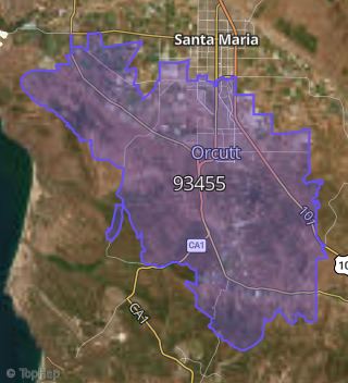
This property is located in Orcutt.
Seasonal Housing units 93455
19%of housing is for seasonal rent.
Daytime Population for 93455
-9%of people during work hours.
Boundary map of Orcutt.
Crime Index for 93455
52
The crime index in 93455 is 52, which is 0.5 times lower than national average.
Market Trends
Historical market data near 392 Cain Dr over selected time period.
Nearby Properties on Cain Dr
- 302 Cain Dr, Santa Maria, CA 93455 is a 1,744 square foot, 3 bedroom, 3.25 bathroom, 0.19 acre property. It was built in 1981 and has an estimate of $587,943 with a price per ft² of $337.
- 172 Cain Dr, Santa Maria, CA 93455 is a 1,747 square foot, 4 bedroom, 3.25 bathroom, 0.19 acre property. It was built in 1984 and has an estimate of $627,893 with a price per ft² of $359.
- 475 Cain Dr, Santa Maria, CA 93455 is a 1,744 square foot, 3 bedroom, 3.25 bathroom, 0.21 acre property. It was built in 1983 and has an estimate of $604,145 with a price per ft² of $346.
- 215 Cain Dr, Santa Maria, CA 93455 is a 1,330 square foot, 3 bedroom, 3.25 bathroom, 0.18 acre property. It was built in 1982 and has an estimate of $558,414 with a price per ft² of $420.
- 292 Cain Dr, Santa Maria, CA 93455 is a 1,402 square foot, 3 bedroom, 3.25 bathroom, 0.21 acre property. It was built in 1984 and has an estimate of $609,985 with a price per ft² of $435.
- 402 Cain Dr, Santa Maria, CA 93455 is a 1,744 square foot, 3 bedroom, 3.25 bathroom, 0.2 acre property. It was built in 1981 and has an estimate of $603,495 with a price per ft² of $346.
- 392 Cain Dr, Santa Maria, CA 93455 is a 1,722 square foot, 3 bedroom, 3.25 bathroom, 0.19 acre property. It was built in 1981 and has an estimate of $633,075 with a price per ft² of $368.
- 412 Cain Dr, Santa Maria, CA 93455 is a 1,330 square foot, 3 bedroom, 3.25 bathroom, 0.17 acre property. It was built in 1981 and has an estimate of $547,915 with a price per ft² of $412.
- 372 Cain Dr, Santa Maria, CA 93455 is a 1,744 square foot, 3 bedroom, 3.25 bathroom, 0.18 acre property. It was built in 1981 and has an estimate of $588,290 with a price per ft² of $337.
- 422 Cain Dr, Santa Maria, CA 93455 is a 1,330 square foot, 3 bedroom, 2 bathroom, 0.16 acre property. It was built in 1983 and has an estimate of $556,750 with a price per ft² of $419.
- 425 Cain Dr, Santa Maria, CA 93455 is a 1,744 square foot, 3 bedroom, 3.25 bathroom, 0.2 acre property. It was built in 1983 and has an estimate of $599,311 with a price per ft² of $344.
- 105 Cain Dr, Santa Maria, CA 93455 is a 1,746 square foot, 4 bedroom, 3.25 bathroom, 0.2 acre property. It was built in 1987 and has an estimate of $655,252 with a price per ft² of $375.
- 125 Cain Dr, Santa Maria, CA 93455 is a 1,883 square foot, 3 bedroom, 3.25 bathroom, 0.2 acre property. It was built in 1987 and has an estimate of $620,319 with a price per ft² of $329.
- 135 Cain Dr, Santa Maria, CA 93455 is a 1,538 square foot, 3 bedroom, 2 bathroom, 0.19 acre property. It was built in 1987 and has an estimate of $586,564 with a price per ft² of $381.
- 145 Cain Dr, Santa Maria, CA 93455 is a 936 square foot, 2 bedroom, 1 bathroom, 0.28 acre property. It was built in 1953 and has an estimate of $463,941 with a price per ft² of $496.
- 155 Cain Dr, Santa Maria, CA 93455 is a 1,453 square foot, 3 bedroom, 2 bathroom, 0.18 acre property. It was built in 1987 and has an estimate of $610,023 with a price per ft² of $420.
- 112 Cain Dr, Santa Maria, CA 93455 is a 1,883 square foot, 3 bedroom, 2 bathroom, 0.21 acre property. It was built in 1987 and has an estimate of $623,574 with a price per ft² of $331.
- 102 Cain Dr, Santa Maria, CA 93455 is a 1,489 square foot, 3 bedroom, 2 bathroom, 0.17 acre property. It was built in 1987 and has an estimate of $561,090 with a price per ft² of $377.
- 132 Cain Dr, Santa Maria, CA 93455 is a 1,798 square foot, 4 bedroom, 3.25 bathroom, 0.23 acre property. It was built in 1987 and has an estimate of $663,545 with a price per ft² of $369.
- 152 Cain Dr, Santa Maria, CA 93455 is a 1,883 square foot, 3 bedroom, 3.25 bathroom, 0.16 acre property. It was built in 1987 and has an estimate of $630,070 with a price per ft² of $335.
- 165 Cain Dr, Santa Maria, CA 93455 is a 1,764 square foot, 3 bedroom, 3.25 bathroom, 0.18 acre property. It was built in 1987 and has an estimate of $635,589 with a price per ft² of $360.
- 115 Cain Dr, Santa Maria, CA 93455 is a 1,489 square foot, 3 bedroom, 3.25 bathroom, 0.19 acre property. It was built in 1987 and has an estimate of $576,961 with a price per ft² of $387.
- 305 Cain Dr, Santa Maria, CA 93455 is a 1,330 square foot, 3 bedroom, 3.25 bathroom, 0.18 acre property. It was built in 1982 and has an estimate of $550,611 with a price per ft² of $414.
- 462 Cain Dr, Santa Maria, CA 93455 is a 1,744 square foot, 3 bedroom, 3.25 bathroom, 0.21 acre property. It was built in 1983 and has an estimate of $586,431 with a price per ft² of $336.
- 235 Cain Dr, Santa Maria, CA 93455 is a 1,744 square foot, 3 bedroom, 3.25 bathroom, 0.18 acre property. It was built in 1981 and has an estimate of $594,125 with a price per ft² of $341.
- View more properties on Cain Dr